Gary is a city in Lake County, Indiana, United States. The population was 69,093 at the 2020 census, making it Indiana's eleventh-most populous city. The city has been historically dominated by major industrial activity and is home to U.S. Steel's Gary Works, the largest steel mill complex in North America. Gary is located along the southern shore of Lake Michigan about 25 miles (40 km) southeast of downtown Chicago. The city is the western gateway to the Indiana Dunes National Park, and is within the Chicago metropolitan area.

Lake County is a county located in the U.S. state of Indiana. In 2020, its population was 498,700, making it Indiana's second-most populous county. The county seat is Crown Point. The county is part of Northwest Indiana and the Chicago metropolitan area, and contains a mix of urban, suburban and rural areas. It is bordered on the north by Lake Michigan and contains a portion of the Indiana Dunes. It includes Marktown, Clayton Mark's planned worker community in East Chicago.

Hammond is a city in Lake County, Indiana, United States. Located along Lake Michigan, it is part of the Chicago metropolitan area and the only city in Indiana to border Chicago. As of the 2020 census, it is the eighth-most populous city in Indiana, with 77,879 residents. It was first settled in the mid-19th century and it is one of the oldest cities of northern Lake County.

East Side is one of the 77 official community areas of Chicago, Illinois. It is on the far south side of the city, between the Calumet River and the Illinois-Indiana state line, 13 miles (21 km) south of downtown Chicago. The neighborhood has a park on Lake Michigan, Calumet Park, and a forest, Eggers Grove Forest Preserve. The forest preserve has hiking/walking trails, picnic grounds and birdwatching. It is served by U.S. Highway 12, U.S. Highway 20, and U.S. Highway 41.

U.S. Route 12 (US 12) is a part of the United States Numbered Highway System that runs from Aberdeen, Washington, to Detroit, Michigan. In the U.S. state of Indiana, it is part of the state road system. US 12 enters the state concurrent with US 20 and US 41 in Hammond. The 46.258 miles (74.445 km) of US 12 that lie within Indiana serve as a major conduit. Some of the highway is listed on the National Highway System (NHS). Various sections are rural two-lane highway, urbanized four-lane undivided highway, and one-way streets. The easternmost community along the highway is Michiana Shores at the Michigan state line.
The Gary Public Transportation Corporation (GPTC) is a commuter bus system in Gary, Indiana that offers service to numerous stops throughout the city and neighboring suburbs. GPTC is a public corporation owned but not directly controlled by the city.
Columbus, the state capital and Ohio's largest city, has numerous neighborhoods within its city limits. Neighborhood names and boundaries are not officially defined. They may vary or change from time to time due to demographic and economic variables.

Interstate 94 (I-94) is a part of the Interstate Highway System that runs from Billings, Montana, to Port Huron, Michigan. I-94 enters Indiana from Illinois in the west, in Munster, and runs generally eastward through Hammond, Gary, and Portage, before entering Michigan northeast of Michigan City. The Interstate runs for approximately 45.8 miles (73.7 km) through the state. The landscape traversed by I-94 includes urban areas of Northwest Indiana, wooded areas, and farmland. The section of I-94 between the Illinois state line and Lake Station is named the Frank Borman Expressway.

Miller Beach is a neighborhood of Gary, Indiana on the southernmost shore of Lake Michigan. First settled in 1851, Miller Beach was originally an independent town. However, the "Town of Miller" was eventually annexed by the then flourishing city of Gary in 1918. Located in the northeastern corner of Lake County, Indiana, the former town is now known as "The Miller Beach Community." Miller Beach borders Lake Michigan to the north, Porter County to the east, and is largely surrounded by protected lands, including Indiana Dunes National Park. Miller Beach is also the closest beach/resort community to Chicago, and has been a popular vacation spot since the early 20th century. As of the 2000 US census, it had a population of 9,900.

U.S. Route 20 (US 20) in Indiana is a main east–west highway that is parallel to the Indiana Toll Road. The western terminus of US 20 is at the Illinois state line and the eastern terminus is at the Ohio state line. US 20 through Whiting, East Chicago, and Gary is concurrent with US 12 twice. The route varies between one-way, two-lane, and four-lane streets, in Northwest Indiana. From the east side of Gary to west of South Bend, US 20 is a four-lane undivided highway. The route then heads around the west and south sides of South Bend and Elkhart as a four-lane limited access divided highway. East of State Road 15 (SR 15), US 20 is two-lane rural highway.
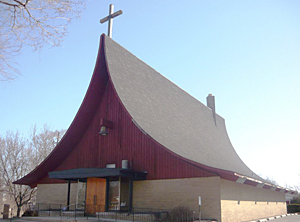
Tolleston is a neighborhood and former town in west-central Gary, Indiana. It is situated south of Ambridge, west of Midtown, east of Westside and north of Black Oak. Tolleston is the site of two large city parks, a historic cemetery, and the oldest church north of the Little Calumet River. The neighborhood's borders are defined by the Norfolk Southern tracks on the north, Grant Street on the east, 25th Avenue on the south, and Clark Road on the west. As of 2000, Tolleston had a population of 14,289, and was 97.5% African-American.

Aetna is a neighborhood in northeastern Gary, Indiana, south of Miller Beach and east of Interstate 65. As of 2000, the neighborhood had a population of 4,942, which was 83% black and 11% white.

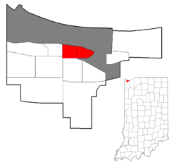
Ambridge Mann, sometimes called Ambridge-Horace Mann or Horace Mann-Ambridge, is a neighborhood in northwestern Gary, Indiana. It is bounded by the Grand Calumet River on the north, by Grant Street on the east, by Chase Street on the west, and by the Norfolk Southern railroad on the south. Adjacent areas include an industrial district to the north, Downtown West to the east, Tolleston to the south, and Brunswick to the west. As of 2000, Ambridge Mann had a population of 6,236, which was 96.3% African-American. Located just south of Interstate 90, the neighborhood can be seen while passing Buchanan Street.

Glen Park, also sometimes called University Park, is the most populous neighborhood in Gary, Indiana. It is situated on the city's far south side, south of the Little Calumet River and Borman Expressway. The neighborhood is often divided into Glen Park East and Glen Park West, on the respective sides of Broadway. Within Gary, Glen Park borders on Black Oak to the west and Midtown and Pulaski to the north; beyond Gary, it adjoins Hobart, Merrillville, and unincorporated Calumet Township. As of 2000, the neighborhood had a population of 25,454, approximately a third of Gary's total population. In terms of race, as of 2000 Glen Park was 86% African-American, 9% white, and 5.5% Hispanic.

Midtown, also called Central, is a neighborhood in central Gary, Indiana. For many decades it was the only African-American neighborhood in the city. It is located south of Downtown West and north of Glen Park along Broadway, Gary's principal thoroughfare. It adjoins the neighborhoods of Tolleston to the west and Pulaski to the east. As of 2000, Midtown had a population of 12,056.

Black Oak is a neighborhood located on the far southwest side of Gary, Indiana. As of 2000, Black Oak had a population of 4,216, which was 84.7% white. It is Gary's only majority-white neighborhood, and the most recent neighborhood added to the city. Black Oak was annexed in 1976, under the administration of mayor Richard Hatcher. Prior to that, Black Oak had been an unincorporated area informally associated with nearby Hammond, and the area has Hammond telephone numbers.

Brunswick is a neighborhood in northwestern Gary, Indiana, just south of Gary Chicago Airport. It borders Hammond and East Chicago to the west, and the Gary neighborhoods of Ambridge Mann to the east and Westside to the south. The borders are defined by the Indiana Toll Road on the north, Chase Street on the east, the Norfolk Southern railway on the south and Cline Avenue on the west. As of 2000, Brunswick had a population of 4,442 people, which was 84.6% African-American and 7.7% white. Like many Gary neighborhoods, Brunswick was a segregated white community until the early 1970s, when a massive white flight occurred.
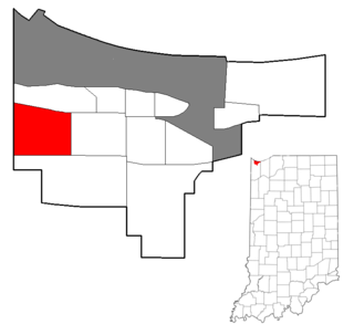
Westside is a neighborhood in west-central Gary, Indiana, USA, bounded by the Cline Avenue expressway on the west, the Norfolk Southern railroad on the north, Clark Road on the east and 25th Avenue on the south. It lies directly east of the Hessville neighborhood of Hammond. Within Gary, it adjoins the neighborhoods of Brunswick, Tolleston and Black Oak. In 2000, Westside had a population of 6,153, which was 63.3% African-American and 31.9% white, with 10.1% Hispanic ethnicity.

Emerson, also called Downtown East, is a neighborhood in north-central Gary, Indiana. Emerson and Downtown West combine to form what is known as Downtown Gary. It was part of the original plat built by the United States Steel Corporation. Emerson is located east of Broadway, south of the Grand Calumet River, north of Ninth Avenue and west of Interstate 65. As of 2000, it had a population of 3,358. Emerson borders directly on Downtown West to the west but is separated from the Aetna and Pulaski neighborhoods to the east and south by an industrial corridor.

Downtown West, is a neighborhood in north-central Gary, Indiana. Emerson and Downtown West combine to form what is known as Downtown Gary. It was part of the original plat built by the United States Steel Corporation. It is located East of Grant Street, south of the Grand Calumet River, north of 9th Avenue and west of Broadway. As of 2000, Downtown West had a population of 4,684. Downtown West borders Emerson to the east, Ambridge Mann to the west, and Midtown to the south.