
Lemont is a village located in Cook, DuPage, and Will counties in the U.S. state of Illinois, and is a suburb of Chicago. The population was 16,000 as of the 2010 census. Lemont is home to Argonne National Laboratory and other heavy industrial sites, and has a substantial European immigrant population.

Joliet is a city in Will and Kendall counties in the U.S. state of Illinois, 30 miles (48 km) southwest of Chicago. It is the county seat of Will County. At the 2020 census, the city was the third-largest in Illinois, with a population of 150,362.

Lockport is a city in Will County, Illinois, United States, located 30 miles southwest of Chicago. The city was incorporated in 1853. It is situated along the Illinois and Michigan (I&M) Canal, and was the headquarters of the canal when the canal was operating. A section of the canal runs through Lockport, including the remains of the canal's Lock No. 1 from which the town received its name. The canal right-of-way is now the Illinois and Michigan National Heritage Corridor. Because of proactive efforts dating back several years, the city of Lockport is one of the best-preserved canal sites in existence today.

Plainfield is a village in Will and Kendall counties, Illinois, United States. The population was 39,581 at the 2010 census and an estimated 44,308 in 2019.
Illinois Route 171 (IL 171) is a 38.61-mile-long (62.14 km) north–south state road in northeastern Illinois. It runs from U.S. Route 6 (US 6) in Joliet north to Illinois Route 72 at the Chicago–Park Ridge border. The section of IL 171 on Archer Avenue from Joliet to Summit is historically significant, originating as a Native American trail, and later serving for a time as part of the first numbered highway between St. Louis and Chicago.
Illinois Route 7 is a northeast–southwest state road in northeastern Illinois. Currently, Illinois 7 runs from U.S. Route 6 at Rockdale north through Joliet, and Crest Hill into Lockport, and then east to Orland Park before terminating at Illinois Route 43 in Worth. Illinois 7 runs for about 28.06 miles (45.16 km).

The Chicago Sanitary and Ship Canal, historically known as the Chicago Drainage Canal, is a 28-mile-long (45 km) canal system that connects the Chicago River to the Des Plaines River. It reverses the direction of the Main Stem and the South Branch of the Chicago River, which now flows out of Lake Michigan rather than into it. The related Calumet-Saganashkee Channel does the same for the Calumet River a short distance to the south, joining the Chicago canal about halfway along its route to the Des Plaines. The two provide the only navigation for ships between the Great Lakes Waterway and the Mississippi River system.
Illinois Route 126 (IL 126) is a 17.25-mile-long (27.76 km) east–west state highway in the northern part of the U.S. state of Illinois. It travels from IL 47 in Yorkville to Interstate 55 (I-55) between Plainfield and Bolingbrook.
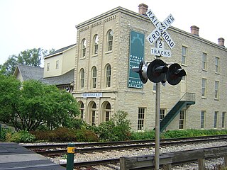
The Gaylord Building, constructed in 1838 in the downtown historic district of Lockport, Illinois, and on the canalside there, played a pivotal role in the construction of the Illinois and Michigan Canal. It is on the United States National Register of Historic Places, and is one of 29 Historic Sites of the National Trust for Historic Preservation. It is constructed of yellow limestone, a common construction material in north central Illinois. It has an Italianate three story addition added in 1859. After falling into disrepair, it was the focus of a concerted restoration and preservation effort that began in 1983, which was later noted as setting a model for such efforts.
Archer Avenue, sometimes known as Archer Road outside the Chicago, Illinois city limits, and also known as State Street only in Lockport, Illinois and Fairmont, Illinois city limits, is a street running northeast-to-southwest between Chicago's Chinatown and Lockport. Archer follows the original trail crossing the Chicago Portage between the Chicago River and the Des Plaines River, and parallels the path of the Illinois and Michigan Canal and the Alton Railroad. As a main traffic artery, it has largely been replaced by the modern Stevenson Expressway.
New York State Route 93 (NY 93) is a 43.08-mile (69.33 km) state highway in western New York in the United States. The route begins at an intersection with NY 18F in the village of Youngstown and runs in a general northwest–southeast direction across Niagara and Erie counties to its east end at an intersection with NY 5 in the town of Newstead, just south of the village of Akron. NY 93 serves as a connector between several major arterials, including NY 104 in Cambria, NY 31 just west of the city of Lockport, and NY 78 south of the city.
U.S. Route 30 (US 30) is an east–west arterial surface road in northern Illinois. It runs from across the Mississippi River from Clinton, Iowa, to Lynwood at the Indiana state line. This is a distance of 153.79 miles (247.50 km).

Wheatland Township is located in Will County, Illinois. As of the 2010 census, its population was 81,472 and it contained 25,075 housing units.
The Chicago and Joliet Electric Railway, or C&JE, was an electric interurban railway linking the cities of Chicago and Joliet, Illinois. It was the only interurban between those cities and provided a link between the streetcar network of Chicago and the cities along the Des Plaines River Valley in north central Illinois, which were served by the Illinois Valley Division of the Illinois Traction System.

The Main Street Historic District in Medina, New York, United States, is the downtown commercial core of the village. It is a 12-acre (4.9 ha) area stretching south along Main Street from the Erie Canal to the railroad tracks.

The Mansion Historic District, sometimes referred to as Mansion Hill, is located south of Empire State Plaza in Albany, New York, United States. It takes its name from the nearby New York State Executive Mansion, which overlooks it. It is a 45-acre (18 ha), 16-block area with almost 500 buildings. Many of them are rowhouses and townhouses built in the middle and late 19th century that remain mostly intact today.

The North Main–Bank Streets Historic District is located along those streets in Albion, New York, United States. It is one of two historic districts in the village, comprising the commercial core of the village, developed during its years as a major stop on the Erie Canal. A portion of the canal, now the New York State Barge Canal, and two of its bridges are within the district.

The Orleans County Courthouse Historic District is one of two located in downtown Albion, New York, United States. Centered on Courthouse Square, it includes many significant buildings in the village, such as its post office and churches from seven different denominations, one of which is the tallest structure in the county. Many buildings are the work of local architect William V.N. Barlow, with contributions from Solon Spencer Beman and Andrew Jackson Warner. They run the range of architectural styles from the era in which the district developed, from Federal to Colonial Revival.

The Lockport Historic District, also known as the Canal and Downtown Area, is a set of fifty-nine buildings in Lockport, Illinois. Of these, fifty-six contribute to the historical integrity of the area.

The Ninth Street Seven Arch Stone Bridge was a historical bridge in Lockport, Illinois. The bridge was the region's first over the Des Plaines River, facilitating trade between farmers west of the river and merchants in Lockport. Farmers were previously forced to use a ford, located near 9th Street. It was approved on March 20, 1868, and cost $4,000. The arch bridge was constructed using locally quarried limestone in eight to twelve inch blocks. Each arch of the bridge spanned 197 foot (60 m). The builder is unknown, but may have been Julius Scheibe, a notable local mason who built many of the city's stone structures of the era. Schiebe was also a highway commissioner during the bridge's construction. A concrete slab had to be added to the foundation of the bridge in the early 1900s due to increased water levels caused by the Chicago Sanitary and Ship Canal. The Ninth Street Seven Arch Stone Bridge was closed to traffic in 1971 and was added to the National Register of Historic Places in 2004.


