Downtown Roanoke

Last updated
Downtown
Roanoke City (Virginia) from Mill Mountain Star at Dusk.jpg
Downtown from the Mill Mountain Star overlook
Coordinates: 37°16′19″N79°56′21″W / 37.27194°N 79.93917°W / 37.27194; -79.93917
CountryUnited States
StateVirginia
City Roanoke
Elevation
925 ft (282 m)
Time zone UTC-5 (EST)
  Summer (DST) UTC-4 (EDT)
ZIP Codes
24011
Area code 540

Downtown is the central business district of Roanoke, Virginia, United States. Developed after the completion of the Shenandoah Valley Railroad in 1882, the Downtown core forms the geographic center of the city and the center of business for the Roanoke Valley and Southwest Virginia, the Roanoke City Market, the Roanoke Downtown Historic District and many other attractions and amenities. [1]

Contents

Location

Geographically, downtown Roanoke is defined by the city as the area bound by Interstate 581 on the east, 5th Street to the west, the Norfolk and Western railroad tracks to the north and Day Avenue to the south. This area is the location of the central core and the historic Market District. An additional section of downtown is located south of Day Avenue, bound to the east by the Roy L. Webber Expressway, South Jefferson Street to the west and Albemarle Avenue to the south. This area is the location of the former Carilion Community Hospital and the Jefferson College of Health Sciences. [2]

Downtown borders the neighborhoods of the West End on the west, Belmont on the east, Gainsboro on the north and both Old Southwest and South Jefferson on the south. [3]

History

The first large European settlement in the area was Gainesborough, established in 1835 northeast of present-day downtown. [4] The first structures of today's downtown area, then dubbed Big Lick, were built after the Virginia and Tennessee Railroad line arrived in 1852. Rail infrastructure was damaged during the Civil War but restored in the Reconstruction era. The first municipal structure completed in present-day downtown was a jail. [5]

By 1881, the Shenandoah Valley Railroad announced that Big Lick would be the southern terminus of its line. This galvanized rapid growth and development, and Big Lick incorporated as the city of Roanoke in 1882. [5] In 1886, citizens approved a $90,000 bond issue for infrastructure, which in turn fostered rapid expansion outward from the present-day intersection of Campbell Avenue and Jefferson Street. [5]

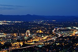
Between World Wars I and II, Downtown continued to prosper and expand. Many new structures were constructed in a variety of contemporary styles, including the nine-story Boxley Building in 1921, the 11-story Patrick Henry Hotel in 1925 and the 12-story Colonial National Bank in 1927, which stood as the city's tallest through the 1970s. [5]

The downtown core saw growth and prosperity into the 1950s, [5] but the opening of Crossroads Mall in 1961 led many Downtown shops to close as consumers chose to shop outside the city center. [6]

Despite the decline in retail sales, the 1970s saw a construction boom that reshaped the skyline. The 13-story Crestar Bank Building (now the BB&T Bank Building) and the 16-story First National Exchange Bank Building (now the Carilion Administrative Services Building) were completed in 1973, while the 14-story Poff Federal Building was completed in 1976. [7]

Established in 1882, the Roanoke City Market is the oldest continuously operating farmers market in the Commonwealth of Virginia and forms the central gathering place of the Downtown district. [1] [8] In the 1960s, the market began to decline, hitting its low point in the 1970s. [1] The Design 79 plan was launched to revitalize and redevelop the market area. [1]

In the early 1990s, Downtown was reshaped with the completion in 1991 of the 21-story Dominion Tower (now the Wells Fargo Tower), the city's tallest structure; and the 12-story Norfolk Southern Building the following year. [7]

In the early 2000s, many former office buildings, stores, and warehouses in the neighborhood were converted into residential living units. [9]

Structures and districts on the National Register

Fire Station #1: The Firehouse was in operation from 1907 through 2007. Roanokefirestation1.jpg
Fire Station #1: The Firehouse was in operation from 1907 through 2007.

Other notable places

Related Research Articles

<span class="mw-page-title-main">Roanoke, Virginia</span> Independent city in Virginia, United States

Roanoke is an independent city in the U.S. state of Virginia. It is located in Southwest Virginia along the Roanoke River, in the Blue Ridge range of the greater Appalachian Mountains, approximately 50 miles (80 km) north of the Virginia–North Carolina border and 250 miles (400 km) southwest of Washington, D.C., along Interstate 81. At the 2020 census, Roanoke's population was 100,011, making it the largest city in Virginia west of the state capital Richmond. It is the principal municipality of the Roanoke metropolitan area, which had a 2020 population of 315,251.

The Greater Richmond, Virginia area has many neighborhoods and districts.

Williamson Road is an approximately 8.0 mi long road in Roanoke City and Roanoke County, Virginia. The road runs from downtown Roanoke in the south through the Botetourt County line in the north. For the majority of its length Williamson Road carries U.S. Route 11. The road was named after the former Williamson farm through which a portion of the road was constructed after Virginia obtained the land through eminent domain.

<span class="mw-page-title-main">U.S. Route 221 in Virginia</span> Highway in Virginia

U.S. Route 221 (US 221) is a part of the U.S. Highway System that runs from Perry, Florida to Lynchburg, Virginia. In Virginia, the U.S. Highway runs 149.61 miles (240.77 km) from the North Carolina state line near Independence north to its northern terminus at US 29 Business, US 460 Business, and US 501 Business in Lynchburg. US 221 connects Independence, Galax, and Hillsville in Southwest Virginia while running concurrently with US 58. The U.S. Highway connects those communities with Roanoke via Floyd County, within which US 221 is the main east–west highway. Entering Bedford County, US 221 exits the Blue Ridge Mountains; it then passes through the Piedmont town of Bedford on its way to Lynchburg and shares a brief overlap with US 460 Business through the town. The U.S. Highway also runs concurrently with US 460 from Roanoke to Bedford and parallels that U.S. Highway from Bedford to Lynchburg.

<span class="mw-page-title-main">Virginia State Route 116</span> State highway in Virginia

State Route 116 is a primary state highway in the U.S. state of Virginia. The state highway runs 20.66 miles (33.25 km) from SR 122 at Burnt Chimney north to SR 101 in Roanoke. SR 116 connects northwestern Franklin County with the southeastern part of Roanoke. The state highway forms a major street through Downtown Roanoke and the city's north side.

<span class="mw-page-title-main">Virginian Railway Passenger Station (Roanoke, Virginia)</span> United States historic place

The Virginian Railway Passenger Station, also known as the Virginian Station is a former rail station listed on the National Register of Historic Places in the South Jefferson neighborhood of the independent city of Roanoke, Virginia, U.S.A. Located at the intersection of Jefferson Street SE and Williamson Road, the Virginian Station served as a passenger station for the Virginian Railway between 1910 and 1956. The station was the only station constructed with brick along the entire length of the Virginian's 608 miles (978 km) network. It was severely damaged by fire on January 29, 2001.

<span class="mw-page-title-main">South Jefferson, Roanoke, Virginia</span> Roanoke Neighborhood in Virginia, United States

South Jefferson is a Roanoke, Virginia neighborhood located in southeast Roanoke, surrounded roughly by the Roanoke River to the south and east and the Roy L. Webber Expressway to the west, centered on South Jefferson Street. It borders the neighborhoods of Old Southwest on the west, Belmont and Downtown on the north, and Riverland/Walnut Hills via the Walnut Street Bridge on the east.

<span class="mw-page-title-main">Gainsboro, Roanoke, Virginia</span> Roanoke Neighborhood in Virginia, United States

Gainsboro is a Roanoke, Virginia neighborhood located in central Roanoke immediately north of Downtown, across the Norfolk Southern Railway right of way, between Interstate 581 and Orange Avenue. It borders the neighborhoods of Harrison and Gilmer on the west, Washington Park on the north, Williamson Road on the east and Downtown Roanoke on the south. As of the 2000 U.S. Census, Gainsboro has a population of 967 residents.

Belmont is a Roanoke, Virginia neighborhood located in southeast Roanoke. It borders the neighborhoods of Hollins and Williamson Road on the north, Morningside and South Jefferson to the south, Downtown on the west and Fallon on the east. Today the neighborhood is bisected by Virginia State Route 24 and is bordered by Interstate 581 to the west.

Washington Park is a neighborhood located in central Roanoke, Virginia, that initially developed in the 1920s as an early Roanoke suburb. It borders the neighborhoods of Roundhill on the north and Williamson Road on the north and east, Gainsboro and Harrison on the south, and Melrose-Rugby on the west. Its northern and eastern boundary is concurrent with Interstate 581, and its southern boundary is concurrent with U.S. Route 460. As of the 2000 census, Harrison had a population of 1,254 residents, with 531 households.

<span class="mw-page-title-main">Mountain View, Roanoke, Virginia</span> Roanoke Neighborhood in Virginia, United States

Mountain View is a Roanoke, Virginia neighborhood located in central Roanoke north of the Roanoke River. It borders the neighborhoods of Norwich on the west, West End on the east, Hurt Park on the north and Raleigh Court and Wasena on the south.

<span class="mw-page-title-main">National Register of Historic Places listings in Detroit</span>

This is a list of the National Register of Historic Places listings in Detroit, Michigan.

<span class="mw-page-title-main">Roanoke Downtown Historic District (Roanoke, Virginia)</span> Historic district in Virginia, United States

The Roanoke Downtown Historic District is a national historic district located in the Downtown Roanoke area of Roanoke, Virginia. It encompasses 122 contributing buildings. It includes a variety of commercial, institutional, social, and governmental buildings and structures from the late 19th century to the mid-20th century. Notable buildings include the Roanoke City Public Library, the YMCA Central Branch Building, First Christian Church (1925), the Central Church of the Brethren (1924), Tomnes Cawley Funeral Home (1928), Thomas B. Mason Building (1961), Peerless Candy Co., City Hall / Municipal Building (1915), Roanoke Times Building (1892), Anchor Building / Shenandoah Building (1910), Greene Memorial Methodist Church (1890), and United States Post Office and Courthouse (1930). Located in the district are the separately listed Patrick Henry Hotel, Boxley Building, Campbell Avenue Complex Historic District, Colonial National Bank, and First National Bank.

<span class="mw-page-title-main">Roanoke City Market Historic District</span> Historic district in Virginia, United States

Roanoke City Market Historic District, also known as City Market District, is a national historic district located in the Downtown Roanoke area of Roanoke, Virginia.

<span class="mw-page-title-main">Old Southwest, Roanoke, Virginia</span> Roanoke Neighborhood in Virginia, United States

Old Southwest is a neighborhood of the independent city of Roanoke, Virginia, United States. Located geographically near the center of the city, Old Southwest was annexed from Roanoke County in 1890 and developed as one of Roanoke's more affluent residential areas. Today the majority of the neighborhood falls within the Southwest Historic District listed on both the Virginia Landmarks Register and the National Register of Historic Places.

The Roanoke Region is the area of the Commonwealth of Virginia surrounding the city of Roanoke. Its usage may refer to the metropolitan statistical area or the Roanoke Valley, but it sometimes includes areas in the Allegheny Mountains and New River Valley which includes Alleghany County, Montgomery County, Covington, Clifton Forge, Blacksburg, Christiansburg, and Radford. Bedford County and Floyd County are sometimes included as part of the region.

<span class="mw-page-title-main">Gainsboro Branch of the Roanoke City Public Library</span> United States historic place

The Gainsboro Branch of the Roanoke City Public Library, also known as the Gainsboro Library, is a historic library building located in the African-American neighborhood of Gainsboro in Northwest Roanoke, Virginia. It was built in 1941–1942, and is a one-story, seven-bay, L-plan Tudor Revival style brick building. The library provided African-American residents of Roanoke's segregated Gainsboro neighborhood with a library facility where children and adults could pursue self-education with advice and assistance from competent and dedicated librarians. It replaced Roanoke's first African-American library which had been established in 1921 in a rented commercial storefront space.

<span class="mw-page-title-main">Roanoke River and Railroad Historic District</span> Historic district in Virginia, United States

The Roanoke River and Railroad Historic District is a predominantly industrial area on the north side of the Roanoke River in Roanoke, Virginia. The area is bounded by South Jefferson Street on the west and the Roanoke River to the east, and extends north as far as Albemarle Avenue. The district's resources are defined primarily by their relationship to the railroad tracks that bisect this area. The area was developed in the late 19th and early 20th centuries with the completion of the Roanoke & Southern line in 1892 and the Virginian Railway line in 1909, and consists primarily of functional industrial buildings that were built between about 1900 and 1930, an example of which is the Virginia Can Company. Notable exceptions are the Virginian Railway Passenger Station, a Spanish Revival passenger station built 1909-10 and listed on the National Register of Historic Places since 2003, and the Walnut Street and Jefferson Street bridges, completed in 1927 and 1928, respectively. Both bridges were constructed in the Art Deco style and designed with "Egyptian Babylonian" style decorations.

Frye and Chesterman was an American architectural firm formed in 1900 by partners Edward Graham Frye (1870–1942) and Aubrey Chesterman (1874–1937) with offices in Lynchburg, Virginia. In 1913 the firm moved to Roanoke, Virginia.

References

  1. 1 2 3 4 "City Market District Plan: Historic Context" (PDF). Duany Plater-Zyberk & Company. Archived from the original (PDF) on 2009-01-08. Retrieved 2008-08-04.
  2. "Outlook Roanoke- The Downtown Area Plan". City of Roanoke Planning Division. Archived from the original on 2010-05-28. Retrieved 2008-08-04.
  3. "Explore Roanoke Neighborhood Map: Downtown". City of Roanoke Department of Neighborhoods. Retrieved 2008-08-04.[ permanent dead link ]
  4. "Gainsboro Neighborhood Plan: History" (PDF). City of Roanoke Planning Division. Archived from the original (PDF) on 2011-07-21. Retrieved 2008-08-04.
  5. 1 2 3 4 5 Blanton, Allison Stone (March 2002). "National Register of Historic Places Registration: Roanoke Downtown Historic District District" (PDF). Retrieved 2008-08-04.
  6. "Williamson Road Area Plan: Development History" (PDF). City of Roanoke Planning Division. Archived from the original (PDF) on 2011-07-21. Retrieved 2008-08-04.
  7. 1 2 "High-rise Buildings of Roanoke". Emporis. Retrieved 2008-08-04.[ dead link ]
  8. "Welcome to Roanoke Farmer's Market". Roanoke Farmer's Market. Archived from the original on 2009-05-18. Retrieved 2008-08-04.
  9. "Downtown Living: Its Time Has Come". The Roanoker. Archived from the original on 2008-07-03. Retrieved 2008-08-04.