
The Ridgeway is a ridgeway or ancient trackway described as Britain's oldest road. The section clearly identified as an ancient trackway extends from Wiltshire along the chalk ridge of the Berkshire Downs to the River Thames at the Goring Gap, part of the Icknield Way which ran, not always on the ridge, from Salisbury Plain to East Anglia. The route was adapted and extended as a National Trail, created in 1972. The Ridgeway National Trail follows the ancient Ridgeway from Overton Hill, near Avebury, to Streatley, then follows footpaths and parts of the ancient Icknield Way through the Chiltern Hills to Ivinghoe Beacon in Buckinghamshire. The National Trail is 87 miles (140 km) long.

Oxfordshire is a ceremonial and non-metropolitan county in South East England. It is locally governed by Oxfordshire County Council and the lower-tier authorities of its five non-metropolitan districts: City of Oxford, Cherwell, South Oxfordshire, Vale of White Horse, and West Oxfordshire. The county is landlocked and bordered by Northamptonshire to the north-east, Warwickshire to the north-west, Buckinghamshire to the east, Berkshire to the south, Wiltshire to the south-west, and Gloucestershire to the west. The areas of Oxfordshire south of the River Thames were part of the historic county of Berkshire, including the county's highest point, the 261-metre (856 ft) White Horse Hill. The largest settlement in the county is Oxford, its only city, with an estimated population of 151,584.

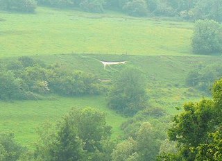
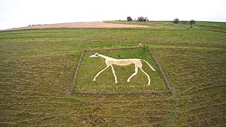
The Uffington White Horse is a prehistoric hill figure, 110 m (360 ft) long, formed from deep trenches filled with crushed white chalk. The figure is situated on the upper slopes of White Horse Hill in the English civil parish of Uffington, some 16 km (10 mi) east of Swindon, 8 km (5.0 mi) south of the town of Faringdon and a similar distance west of the town of Wantage; or 2.5 km (1.6 mi) south of Uffington. The hill forms a part of the scarp of the Berkshire Downs and overlooks the Vale of White Horse to the north. The best views of the figure are obtained from the air, or from directly across the Vale, particularly around the villages of Great Coxwell, Longcot, and Fernham.

Uffington Castle is an early Iron Age univallate hillfort in Oxfordshire, England. It covers about 32,000 square metres and is surrounded by two earth banks separated by a ditch with an entrance in the western end. A second entrance in the eastern end was apparently blocked up a few centuries after it was built. The original defensive ditch was V-shaped with a small box rampart in front and a larger one behind it. Timber posts stood on the ramparts. Later the ditch was deepened and the extra material dumped on top of the ramparts to increase their size. A parapet wall of sarsen stones lined the top of the innermost rampart. It is very close to the Uffington White Horse on White Horse Hill.
The Vale of White Horse is a local government district of Oxfordshire in England. It was historically a north-west projection of Berkshire. The area is commonly referred to as the 'Vale of the White Horse'. It is crossed by the Ridgeway National Trail in its far south, across the North Wessex Downs AONB at the junction of four counties. The northern boundary is defined by the River Thames. The name refers to Uffington White Horse, a prehistoric hill figure.

Westbury or Bratton White Horse is a hill figure on the escarpment of Salisbury Plain, approximately 1.5 mi (2.4 km) east of Westbury in Wiltshire, England. Located on the edge of Bratton Downs and lying just below an Iron Age hill fort, it is the oldest of several white horses carved in Wiltshire. It was restored in 1778, an action which may have obliterated another horse that had occupied the same slope. A contemporary engraving from around 1772 appears to show a horse facing in the opposite direction that was rather smaller than the present figure. There is, however, no documentation or other evidence for the existence of a chalk horse at Westbury before 1772.
The Berkshire Downs are a range of chalk downland hills in South east England split between the counties of Berkshire and Oxfordshire. They are part of the North Wessex Downs Area of Outstanding Natural Beauty. The western parts of the downs are also known as the Lambourn Downs.

The North Wessex Downs Area of Outstanding Natural Beauty (AONB) is located in the English counties of Berkshire, Hampshire, Oxfordshire and Wiltshire. The name North Wessex Downs is not a traditional one, the area covered being better known by various overlapping local names, including the Berkshire Downs, the North Hampshire Downs, the White Horse Hills, the Lambourn Downs, the Marlborough Downs, the Vale of Pewsey and Savernake Forest.
Uffington is a village and civil parish in Oxfordshire, about 4 miles (6.4 km) south of Faringdon and 6 miles (10 km) west of Wantage. The 2011 Census recorded the parish's population as 783. It was originally in the county of Berkshire, but under the Local Government Act 1972 it was transferred for local government purposes to Oxfordshire. The Uffington White Horse hill figure is on the Berkshire Downs on the south side of the parish. The village has been twinned with Le Chevain in France since 1991.

A hill figure is a large visual representation created by cutting into a steep hillside and revealing the underlying geology. It is a type of geoglyph usually designed to be seen from afar rather than above. In some cases trenches are dug and rubble made from material brighter than the natural bedrock is placed into them. The new material is often chalk, a soft and white form of limestone, leading to the alternative name of chalk figure for this form of art.

Whitehorse Hill is a hill in the Berkshire Downs in Oxfordshire, England, west of Wantage. At 261 metres (856 ft), it is the highest point in Oxfordshire. Uffington Castle lies on the summit of the hill, and the Uffington White Horse is on the hill's northern slope. The hill and an adjacent area below, including Dragon Hill and The Manger, make up a 98.9-hectare (244-acre) biological and geological Site of Special Scientific Interest.

"Cloudbusting" is a song written, produced and performed by English singer Kate Bush. It was the second single released from her fifth studio album Hounds of Love (1985). "Cloudbusting" peaked at No. 20 on the UK Singles Chart.

Cherhill White Horse is a hill figure on Cherhill Down, 3.5 miles east of Calne in Wiltshire, England. Dating from the late 18th century, it is the third oldest of several such white horses in Great Britain, with only the Uffington White Horse and the Westbury White Horse being older. The figure is also sometimes called the Oldbury White Horse.
Faringdon was a rural district in the administrative county of Berkshire from 1894 to 1974.
Marlborough White Horse, also called the Preshute White Horse, is a hill figure on Granham Hill, a fairly shallow slope of the downland above the hamlet of Preshute, southwest of Marlborough in the county of Wiltshire, England. Dating from 1804, it is one of several such white horses to be seen around Great Britain, and one of nine in Wiltshire.

Woolstone is a village and civil parish about 4+1⁄2 miles (7 km) south of Faringdon in the Vale of White Horse. Woolstone was part of Berkshire until the 1974 boundary changes transferred it to Oxfordshire. The 2011 Census recorded the parish population as 210.
Pewsey White Horse is a hill figure of a white horse near the village of Pewsey, Wiltshire, England. Cut of chalk in 1937, it replaces an earlier horse that had disappeared under the grass and is one of eight remaining white horses in Wiltshire. It measures 66’ by 45’, making it the smallest of the eight canonical white horses in Wiltshire.

Hackpen, Warren & Gramp's Hill Downs is a 71.4-hectare (176-acre) biological Site of Special Scientific Interest in Letcombe Bassett in Oxfordshire.

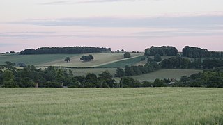
Westmill Woodland Burial Ground is a green burial ground in the Vale of White Horse on the border of Oxfordshire with Wiltshire in southern England. In the distance, the Uffington White Horse, an Iron Age horse carved into the white chalk on the Berkshire Downs, can be seen to the south-east.

The Litlington White Horse is a chalk hill figure depicting a horse, situated on Hindover Hill in the South Downs, looking over the River Cuckmere to the west of the village of Litlington and north of East Blatchington in East Sussex, England.


