
Gardnerville is an unincorporated town in Douglas County, Nevada, adjacent to the county seat of Minden. The population was 6,211 at the time of the 2020 Census.

The Black Rock Desert is a semi-arid region of lava beds and playa, or alkali flats, situated in the Black Rock Desert–High Rock Canyon Emigrant Trails National Conservation Area, a silt playa 100 miles (160 km) north of Reno, Nevada that encompasses more than 300,000 acres (120,000 ha) of land and contains more than 120 miles (200 km) of historic trails. It is in the northern Nevada section of the Great Basin with a lakebed that is a dry remnant of Pleistocene Lake Lahontan.

Pyramid Lake is the geographic sink of the basin of the Truckee River, 40 mi (64 km) northeast of Reno, Nevada, United States.

Gerlach, Nevada is a census-designated place (CDP) in Washoe County, Nevada, United States. The population was 130 at the 2020 census. It is part of the Reno–Sparks Metropolitan Statistical Area. Prior to 2010, Gerlach was part of the Gerlach–Empire census-designated place. The town of Empire is now a separate CDP. The next nearest town, Nixon, is 60 miles (100 km) to the south on a reservation owned by the Pyramid Lake Paiute Tribe. The Fly Geyser is located near Gerlach.

The Carson River is a northwestern Nevada river that empties into the Carson Sink, an endorheic basin. The main stem of the river is 131 miles (211 km) long although the addition of the East Fork makes the total length 205 miles (330 km), traversing five counties: Alpine County in California and Douglas, Storey, Lyon, and Churchill Counties in Nevada, as well as the Consolidated Municipality of Carson City, Nevada. The river is named for Kit Carson, who guided John C. Frémont's expedition westward up the Carson Valley and across Carson Pass in winter, 1844. The river made the National Priorities List (NPL) on October 30, 1990 as the Carson River Mercury Superfund site (CRMS) due to investigations that showed trace amounts of mercury in the wildlife and watershed sediments.
New Washoe City is an unincorporated community located in Washoe County, Nevada, United States. It is located in the Washoe Valley in southern Washoe County between Reno and Carson City, on the east side of Washoe Lake. It is part of the Reno–Sparks Metropolitan Statistical Area. As of the 1990 census, New Washoe City had a population of 2,875. The area was not listed as a census-designated place (CDP) at the 2000 census but was listed as "Washoe Valley, Nevada", for the 2010 census, at which time it had a population of 3,019.

The Reno-Sparks Indian Colony in Nevada was established in the early 1900s by members of related tribes who lived near Reno for work; they became a federally recognized tribe in 1934 after forming a government under the Indian Reorganization Act.
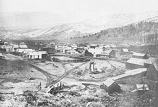
Old Washoe City is a ghost town in Washoe County, Nevada, in the United States. Nearby there is a new community called New Washoe City.

Washoe Lake is a lake located near Carson City in the Washoe Valley of Washoe County, Nevada. It is a very shallow lake with a surface area that can vary greatly from year to year. Washoe Lake State Park sits on the lake's southeastern shore.

Ward Charcoal Ovens State Historic Park is an area designated for historic preservation and public recreation located 20 miles (32 km) south of the town of Ely in White Pine County, Nevada. The 700-acre (280 ha) state park protects beehive-shaped charcoal ovens constructed in the latter half of the 19th century.

Galena is an abandoned town in Washoe County, Nevada, south of Reno. The portion of Reno just south of Mount Rose Highway and west of Steamboat Springs is also known as Galena.

U.S. Route 395 (US 395) is an 85-mile-long (137 km) United States Numbered Highway near Lake Tahoe in the state of Nevada. It traverses the state after entering from California in Topaz Lake and crosses back into California near Hallelujah Junction. US 395 serves the cities of Gardnerville, Minden, Carson City and Reno. All of US 395 north of Carson City is a freeway and is built up to Interstate Highway standards. Part of the freeway section is also designated as Interstate 580 (I-580). US 395 is an important regional highway, serving the communities of Western Nevada, connecting them to other major communities via California, and it is the only major north–south arterial for the geographically isolated region.
Empire and Carson River mills is an historic area in Carson City, Nevada. The mills were established along the Carson River near Empire, now part of Carson City.

The Washoe Tribe of Nevada and California are a federally recognized tribe of Washoe Indians, living in California and Nevada. They are several communities south and east of Lake Tahoe united under a tribal council. The washoe people own over 64,300 acres (26,000 ha) in public domain allotments & PDAs are land reserved out of the public domain for use by an Indian person or family, but unlike larger reservations, they are not connected to any Native Tribes or governments and are not subject to Tribal jurisdiction. Nevertheless, PDAs are Indian country.

The East Fork Carson River is the largest tributary of the Carson River, flowing through California and Nevada in the western United States. The north-flowing river is 61 miles (98 km) long and drains a mostly rural, mountainous watershed of 392 square miles (1,020 km2).
Sutro, Nevada is a ghost town in Lyon County, Nevada, near where the Sutro Tunnel is located.
Clark is an unincorporated community in northern Storey County and southern Washoe County, about 17 miles (27 km) east of Reno and Sparks. Clark can be accessed from the north via Interstate 80 on the USA Parkway exit, and from the west via roads from nearby Lockwood.

Ophir Creek is a 7.7-mile (12.4 km) eastward-flowing stream originating in Tahoe Meadows just south of Tamarack Peak and southeast of Mount Rose Summit, a pass on Nevada State Highway 431. Ophir Creek flows to Washoe Lake in Washoe County in western Nevada, shortly after passing under U.S. Route 395.

