

A drill hall is a place such as a building or a hangar where soldiers practise and perform military drills.
A drill hall is a place such as a building or a hangar where soldiers practise and perform military drills.
In the United Kingdom and Commonwealth, the term was used for the whole headquarters building of a military reserve unit, which usually incorporated such a hall. Many of these drill halls were built through public subscriptions in order to support the local Volunteer Force which was raised in the late 1850s. [1]
In the United Kingdom, these were later renamed Territorial Army (TA) Centres and later Army Reserve Centres (ARC)s. [2] As well as a drill hall itself, they now usually feature other facilities such as a gymnasium, motor transport department, lecture rooms, stores, an armoury, administrative offices and the Officer's, Warrant Officers and Senior NCOs, and Junior Ranks Messes. Some Officer Training Corps, Army Cadet Force and Air Training Corps units are also co-located on the site of modern Army Reserve Centres, for example Blackheath drill hall. [3]
Over 1,860 drill halls have been documented in England, with Historic England estimating that around 1,500 were extant in 2015. [4] Fifteen purpose built drill halls are Grade II listed on the National Heritage List for England, dating from 1864 to 1907. [5] The Grade II listed [6] former Drill Hall on York Road, Great Yarmouth was built for the 2nd Volunteer Battalion Norfolk Regiment in 1867. [7] Other drill halls were converted from extant buildings, including the now demolished St Nicholas Drill Hall in King's Lynn in Norfolk. [8]

Great Yarmouth, often called Yarmouth, is a seaside town which gives its name to the wider Borough of Great Yarmouth in Norfolk, England; it straddles the River Yare and is located 20 miles (30 km) east of Norwich. Its fishing industry, mainly for herring, shrank after the mid-20th century and has all but ended. North Sea oil from the 1960s supplied an oil-rig industry that services offshore natural gas rigs; more recently, offshore wind power and other renewable energy industries have ensued.

Wymondham is a market town and civil parish in the South Norfolk district of Norfolk, England, 12 miles (19 km) south-west of Norwich off the A11 road to London. The River Tiffey runs through. The parish, one of Norfolk's largest, includes rural areas to the north and south, with hamlets of Suton, Silfield, Spooner Row and Wattlefield. It had a population of 14,405 in 2011, of whom 13,587 lived in the town itself.

Holt is a market town, civil parish and electoral ward in the English county of Norfolk. The town is 22.8 miles (36.7 km) north of the city of Norwich, 9.5 miles (15.3 km) west of Cromer and 35 miles (56 km) east of King's Lynn. The town has a population of 3,550, rising and including the ward to 3,810 at the 2011 census. Holt is within the area covered by North Norfolk District Council. Holt has a heritage railway station; it is the south-western terminus of the preserved North Norfolk Railway, known as the Poppy Line.

Downham Market, sometimes simply referred to as Downham, is a market town and civil parish in Norfolk, England. It lies on the edge of the Fens, on the River Great Ouse, approximately 11 miles south of King's Lynn, 39 miles west of Norwich and 30 miles north of Cambridge.
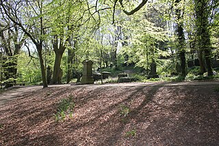
The General Cemetery in the City of Sheffield, England opened in 1836 and closed for burial in 1978. It was the principal cemetery in Victorian Sheffield with over 87,000 burials. Today it is a listed Landscape on the English Heritage National Register of Historic Parks and Gardens. It is also a Local Nature Reserve. It is owned by the City of Sheffield and managed on behalf of the city by a local community group, the Sheffield General Cemetery Trust.

Downham Market railway station is on the Fen line in the east of England, serving the town of Downham Market, Norfolk. It is 86 miles 8 chains (138.6 km) measured from London Liverpool Street and is situated between Littleport and Watlington stations. Its three-letter station code is DOW.

Gunthorpe is a village and a civil parish in the English county of Norfolk. The village is 8.6 miles east north east of the town of Fakenham, 14.9 miles west south west of Cromer and 122 miles north north east of London. The nearest railway station is at Sheringham for the Bittern Line which runs between Sheringham, Cromer and Norwich. The nearest airport is Norwich International Airport.

Honing is a village and a civil parish in the English county of Norfolk. The village is 15 miles (24 km) north-northeast of Norwich, 13 miles (21 km) south east of Cromer and 4 miles (6.4 km) east of North Walsham.

Dragon Hall is a Grade-1 listed medieval merchant's trading hall located in King Street, Norwich, Norfolk, close to the River Wensum, and since 2018 home to the National Centre for Writing. It is thought to be unique in being the only such trading hall in Northern Europe to be owned by one man. The building stands on what was the main road through the city in the 15th century, with river transport links via Great Yarmouth to the Low Countries. Dragon Hall is now acknowledged as one of Norwich's medieval architectural gems and an iconic building in the city.

Old Hunstanton is a village and civil parish in the English county of Norfolk. It covers an area of 5.35 km2 (2.07 sq mi) and had a population of 47 in 25 households at the 2001 census. The population had risen to 628 at the 2011 Census. For the purposes of local government, it falls within the district of King's Lynn and West Norfolk.
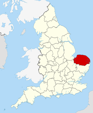
The county of Norfolk is divided into seven districts, namely Norwich, South Norfolk, Great Yarmouth, Broadland, North Norfolk, King's Lynn and West Norfolk, and Breckland.
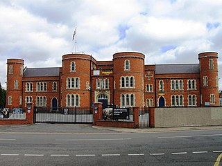
Somme Barracks, Sheffield is a military establishment situated on Glossop Road in Sheffield, England. The building is owned by the Ministry of Defence and serves as the base of the University of Sheffield Officers' Training Corps which has been apart of the Yorkshire Officer Training Regiment since 2011. It is a Grade II listed building.

Chenies Street is a street in Bloomsbury, London, that runs between Tottenham Court Road and Gower Street. It is the location of a number of notable buildings such as Minerva House, the Drill Hall, and a memorial to The Rangers, 12th County of London Regiment. North Crescent starts and ends on the northern side of Chenies Street.

The former Salvation Army Hall in Godalming, Surrey, England, now an office building known as Aurum House, has been used by three religious groups since its construction c. 1830. The ancient town in the English county of Surrey has a long and diverse history of Protestant Nonconformity, and three Nonconformst denominations are represented: at first it served Congregationalists, but when they built a larger chapel in the town it passed to the Methodist Church. In the 20th century it was occupied by The Salvation Army, but it closed in 2012 and was redeveloped for commercial use. The building has been listed at Grade II for its architectural and historical importance.

The Army Riding School was a military installation in Northumberland Road, Newcastle upon Tyne.

The Bethel Street drill hall office is a former military installation in Norwich, Norfolk. It is a Grade II* listed building.
The Clare Street drill hall is a military installation in Northampton, Northamptonshire. It is a Grade II listed building.

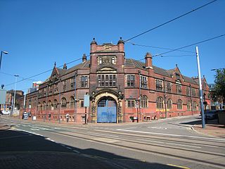
The Burlington Street drill hall is a former military installation in Greenheys, Manchester. Since the 1940s it has been used by the Victoria University of Manchester for physical education. More recently it has been used as a Physical Education Centre and Islamic Prayer Hall by the university.

Our Lady of the Annunciation Church is a Roman Catholic parish church in King's Lynn, Norfolk, England. It was built in 1897, but incorporates parts of the former church on the same site that was built in 1845 and designed by Augustus Pugin. It is located on the corner of London Road and North Everard Street in the centre of the town. Its construction was partially paid for by the then Prince of Wales, Edward VII. It was also the national shrine of Our Lady of Walsingham until 1934. It is now a pontifical shrine, and was awarded Grade II listed status in 2022.
![]() Media related to Drill halls at Wikimedia Commons
Media related to Drill halls at Wikimedia Commons
| | This military-related article is a stub. You can help Wikipedia by expanding it. |