Related Research Articles

A natural disaster is the highly harmful impact on a society or community following a natural hazard event. Some examples of natural hazard events include: flooding, drought, earthquake, tropical cyclone, lightning, tsunami, volcanic activity, wildfire. A natural disaster can cause loss of life or damage property, and typically leaves economic damage in its wake. The severity of the damage depends on the affected population's resilience and on the infrastructure available. Scholars have been saying that the term natural disaster is unsuitable and should be abandoned. Instead, the simpler term disaster could be used, while also specifying the category of hazard. A disaster is a result of a natural or human-made hazard impacting a vulnerable community. It is the combination of the hazard along with exposure of a vulnerable society that results in a disaster.

The Soviet Union incorporated an area of over 22,402,200 square kilometres (8,649,500 sq mi), covering approximately one-sixth of Earth's land surface. It was only slightly smaller in land area than the entire continent of North America and spanned most of Eurasia. Its largest and most populous republic was the Russian SFSR which covered roughly three-quarters of the surface area of the union, including the complete territory of contemporary Russia.

Lake Hāmūn, or the Hamoun Oasis, is a seasonal lake and wetlands in the endorheic Sīstān Basin in the Sistan region on the Afghanistan–Iran border. In Iran, it is also known as Hāmūn-e Helmand, Hāmūn-e Hīrmand, or Daryācheh-ye Sīstān.

Environmental issues in Afghanistan are monitored by the National Environmental Protection Agency (NEPA). They predate the political turmoil of the past few decades. Forests have been depleted by centuries of grazing and farming, practices which have only increased with modern population growth.

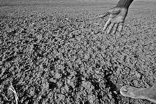
Ajristan, also known as Dāya (دایه), or Dāya wa Folād, Ajristan also spelled as Ajeristan, is a district in the western part of Ghazni province, Afghanistan. Its population was estimated at 62,028 in 2001, of which 90% are Pashtun people with others from the Hazara people. Sangar, in the center of the district, is the capital. Most of the population live in the Jikhai River valley and depend upon agriculture, the main source of its economy. The last decade of severe winters and droughts have affected the economy and quality of life..

Drought in Australia is defined by the Australian Bureau of Meteorology as rainfall over period greater than three-months being in the lowest decile of what has been recorded for that region in the past. This definition takes into account that drought is a relative term and rainfall deficiencies need to be compared to typical rainfall patterns including seasonal variations. Specifically, drought in Australia is defined in relation to a rainfall deficiency of pastoral leases and is determined by decile analysis applied to a certain area. Note that this definition uses rainfall only because long-term records are widely available across most of Australia. However, it does not take into account other variables that might be important for establishing surface water balance, such as evaporation and condensation.
Drought in India has resulted in millions of deaths over the years. Indian agriculture is heavily dependent on the country's climate: a favorable monsoon is critical to securing water for irrigating India's crops. In parts of India, failure of the monsoons causes water shortages, resulting in poor yields. This is particularly true of major drought-prone regions southeastern Maharashtra, northern Karnataka, Andhra Pradesh, Odisha, Gujarat, Telangana, and Rajasthan.

The United States' contiguous western and especially southwestern region has experienced widespread drought since about year 2000. Below normal precipitation leads to drought, and is caused by an above average persistence of high pressure over the affected area. Changes in the track of extratropical cyclones, which can occur during climate cycles such as the El Niño-Southern Oscillation, or ENSO, as well as the North Atlantic Oscillation, Pacific Decadal Oscillation, and Atlantic multidecadal oscillation, modulate which areas are more prone to drought. Increased drought frequency and severity is also expected to be one of the effects of global warming.

Pakistan's climate varies from a continental type of climate in the north, a mountainous dry climate in the west (Baluchistan), a wet climate in the East (Punjab) an arid climate in the Thar Desert, to a tropical climate in the southeast, characterized by extreme variations in temperature, both seasonally and daily, because it is located on a great landmass barely north of the Tropic of Cancer.
The 2000s drought in Australia, also known as the millennium drought is said by some to be the worst drought recorded since European settlement.

The global weather activity of 2010 includes major meteorological events in the Earth's atmosphere during the year, including winter storms, hailstorms, out of season monsoon rain storms, extratropical cyclones, gales, microbursts, flooding, rainstorms, tropical cyclones, and other severe weather events.

The Geography of Atlanta encompasses 132.4 square miles (342.9 km2), of which 131.7 square miles (341.1 km2) is land and 0.7 square miles (1.8 km2) is water. The city is situated among the foothills of the Appalachian Mountains, and at 1,050 feet (320 m) above mean sea level, Atlanta has the highest elevation among major cities east of the Mississippi River. Atlanta straddles the Eastern Continental Divide, such that rainwater that falls on the south and east side of the divide flows into the Atlantic Ocean, while rainwater on the north and west side of the divide flows into the Gulf of Mexico. Atlanta sits atop a ridge south of the Chattahoochee River, which is part of the ACF River Basin. Located at the far northwestern edge of the city, much of the river's natural habitat is preserved, in part by the Chattahoochee River National Recreation Area.

The 2012–2013 North American drought, an expansion of the 2010–2013 Southern United States drought, originated in the midst of a record-breaking heat wave. Low snowfall amounts in winter, coupled with the intense summer heat from La Niña, caused drought-like conditions to migrate northward from the southern United States, wreaking havoc on crops and water supply. The drought inflicted significant economic ramifications for the affected states. It exceeded, in many measures, the 1988–1989 North American drought, the most recent comparable drought.

The Somali Flash Floods are a group of flash floods that occur annually in the country of Somalia. The floods are a result of the Gu rains, which is the monsoon like rainfall that comes every March in the region. Every year, in the period shortly after the Gu rains from March to July, flash floods hit the lower Jubba and lower Shabelle regions of Somalia. These flash floods cause devastation and destruction, causing casualties and displacement. In recent years, the effects of the floods have increased compared to past floods. This is due to Somali population increase and continuing lack of preparation mechanisms, and they may be exemplified by meteorological reasons as well.

The historical and ongoing droughts in California result from various complex meteorological phenomena, some of which are not fully understood by scientists.

Climate change in Minnesota encompasses the effects of climate change, attributed to human-caused increases in atmospheric carbon dioxide, in the U.S. state of Minnesota.
The 2018–2021 Southern Africa drought was a period of drought that took place in Southern Africa. The drought began in late October 2018, and negatively affected food security in the region. In mid-August 2019, the drought was classified as a level 2 Red-Class event by the Global Disaster Alert and Coordination System. The alert level was reduced to the Orange-1.7 by 12 December 2019, as the new wet season had started. In September 2020, the drought was classified as a level 2 Red-Class event. The drought continued into early 2021. Beginning in October 2021, South Africa experienced above average rainfall and reservoirs refilled by early 2022.
A series of flash floods occurred in Afghanistan beginning in June 2020, with the largest and most impactful flood occurring on 26 August 2020. They were caused by torrential rain in Charikar, Parwan Province. The August floods killed at least 179 people and injured 212 others, and destroyed hundreds of houses. The Ministry of Disaster Management has also reported some casualties and destruction of infrastructure in the provinces of Kapisa, Maidan Wardak, Nangarhar, Panjshir, and Paktia.

Between 2008 and early 2010, Kenya, one of the countries of Eastern Africa, was affected by a severe drought, which put ten million people at risk of hunger and caused a large number of deaths to livestock in Kenyan Arid and Semi-Arid Lands (ASALs), constituting around 88% of the country.
References
- 1 2 Severe drought hits Afghanistan. October 6, 2011
- ↑ ABC News Australia, 145 'presumed dead' in Afghan avalanche