Abu Snan is a local council in the Galilee region of northern Israel, with an area of 4,750 dunams (4.75 km²). It achieved recognition as an independent local council in 1964. It is a religiously mixed town, with a Muslim majority and sizable Druze and Christian minorities. According to the Israel Central Bureau of Statistics (CBS), in 2021 Abu Snan had a total population of 14,455.
Sajur is a Druze town in the Galilee region of northern Israel, with an area of 3,000 dunams (3 km²). It achieved recognition as an independent local council in 1992. In 2021 it had a population of 4,425.
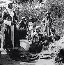
Maghar is a city of mixed population of Muslims, Christians, and Druze in Israel's Northern District with an area of 19,810 dunams. Maghar was given the status of a local council in 1956, and of a city in 2021. In 2021 it had a population of 23,624. Its population consists of 57% Druze, 23% Christians, and 20% Muslims.
Julis is a Druze village and local council in the Northern District of Israel. In 2021 it had a population of 6,657.

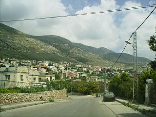
Yarka, officially Yirka, is an Israeli Druze village and local council in the Northern District of Israel. In 2019 it had a population of 17,171, 98.8% of them members of the Druze community, with a small Muslim (1.0%) and Christian (0.1%) minorities.

Kafr Qara is an Arab city in Israel 22 miles (35 km) southeast of Haifa. In 2021 its population was 19,691. Kafr Qara holds the record for doctors relative to population size in the country with around 14.8 doctors per 1,000 citizens, and is also known for recording a high rate of academics and master's degree holders.
Muqeible or Muqeibla, meaning "The front place", is an Arab town in Israel's Northern District, situated in the Jezreel Valley between Jenin in the West Bank and the Ta'anakh area. It is a part of the Gilboa Regional Council.In 2021 its population was 4,260. The inhabitants are Muslims and Christians.
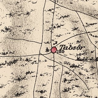
Tabsur, also Khirbat 'Azzun, was a Palestinian village located 19 kilometres southwest of Tulkarm. In 1931, the village had 218 houses and an elementary school for boys. Its Palestinian population was expelled during the 1948 Arab-Israeli war.
Khirbat al-Sarkas was a village in Palestine, located 42 kilometres south of Haifa. It was depopulated during the 1948 Arab-Israeli war.

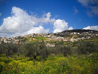
Yanuh-Jat is an Israeli Druze village and local council in the Northern District of Israel, northeast of Acre, consisting of the villages of Yanuh and Jat, which merged in 1990. In 2021 it had a population of 6,851, all members of the Druze community.

Ein al-Asad is a Druze village in northern Israel. Located near Maghar in the Galilee, it falls under the jurisdiction of Merom HaGalil Regional Council. As of 2021 it had a population of 904.

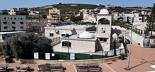
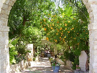
Isfiya, also known as Ussefiya or Usifiyeh, is a Druze-majority village in northern Israel, governed by a local council. It also includes Christians, Muslims and a few Jewish households. Located on Mount Carmel, it is part of the Haifa District. In 2021 its population was 12,136. In 2003, the local council was merged with nearby Daliyat al-Karmel to form Carmel City. However, the new city was dissolved in 2008 and the two villages resumed their independent status.

Masil al-Jizl was a Palestinian Arab village in the District of Baysan. It was depopulated by the Israel Defense Forces during the Arab-Israeli War. It was attacked and depopulated on May 31, 1948, as part of Operation Gideon.
Hulayqat was a Palestinian Arab village in the Gaza Subdistrict. It was depopulated during the 1947–1948 Civil War in Mandatory Palestine. It was located 20.5 km northeast of Gaza.
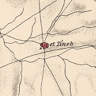
Al-Tina, or Khirbet et-Tineh was a Palestinian Arab village in the Ramle Subdistrict of Mandatory Palestine. The village was located between the Shfela and southern Israeli coastal plain. It was depopulated during the 1948 Arab–Israeli War on July 8, 1948, by the Givati Brigade under Operation An-Far. It was located 20. km south of Ramla. The hill on which the village was built stands today next to the Kiryat Mal'akhi – Yoav railway station and next to Highway 6. Archeological excavations at the site revealed the remains of a Byzantine settlement.
Arab al-Zubayd was a Palestinian village in the Safad Subdistrict. It was depopulated during the 1947–1948 Civil War in Mandatory Palestine on April 20, 1948, when the villagers fled on hearing the intentions of The Palmach's First Battalion of Operation Yiftach. It was located 15 km northeast of Safad, near the al-Mutilla-Safad—Tiberias highway.
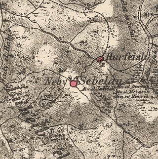
Sabalan was a Palestinian Arab village in the Safad Subdistrict, located 15.5 kilometers (9.6 mi) northwest of Safad. It stood at an elevation of 800 meters (2,600 ft) above sea level overlooking the Druze village of Hurfeish. In 1945, Sabalan had a population of 70. It was depopulated during the 1948 Palestine War.

Al-Mansura was a Palestinian Arab village in the Tiberias Subdistrict. It was depopulated during the 1947–1948 Civil War in Mandatory Palestine on May 10, 1948. It was located 16 kilometres northwest of Tiberias.

Al-Samra was a Palestinian Arab village in the Tiberias Subdistrict. It was depopulated on April 21, 1948, during the 1947–1948 Civil War in Mandatory Palestine. It was located 10 km southeast of Tiberias.
Wadi al-Hawarith was a Palestinian bedouin camping site in the Tulkarm Subdistrict. It was depopulated at the outbreak of the 1948 Arab–Israeli War on March 15, 1948, following the 1947–48 Civil War in Mandatory Palestine. It was located 16.5 km northwest of Tulkarm. Wadi al-Hawarith was mostly destroyed with the exception of four houses.