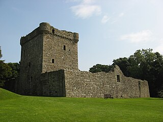
Lochleven Castle is a ruined castle on an island in Loch Leven, in the Perth and Kinross local authority area of Scotland. Possibly built around 1300, the castle was the site of military action during the Wars of Scottish Independence (1296–1357). In the latter part of the 14th century, the castle was granted to William Douglas, 1st Earl of Douglas, by his uncle. It remained in the Douglases' hands for the next 300 years. Mary, Queen of Scots, was imprisoned there in 1567–68, and forced to abdicate as queen, before escaping with the help of her gaoler's family. In 1588, the queen's gaoler inherited the title of Earl of Morton, and moved away from the castle. In 1675, Sir William Bruce, an architect, bought the castle and used it as a focal point for his garden; it was never again used as a residence.

Clan Scott is a Scottish clan and is recognised as such by the Lord Lyon King of Arms. Historically the clan was based in the Scottish Borders.

Smailholm Tower is a peel tower at Smailholm, around five miles (8 km) west of Kelso in the Scottish Borders. Its dramatic situation, atop a crag of Lady Hill, commands wide views over the surrounding countryside. The tower is located at grid reference NT637346, just west of Sandyknowe farm, and is now a Scheduled Ancient Monument in the care of Historic Environment Scotland. In June 2007, it was awarded the maximum "five-star" status as a tourist attraction from VisitScotland, a rating bestowed on only eight other sites in Scotland.

Craignethan Castle is a ruined castle in South Lanarkshire, Scotland. It is located above the River Nethan, a tributary of the River Clyde, at NS816464. The castle is two miles west of the village of Crossford, and 4.5 miles north-west of Lanark. Built in the first half of the 16th century, Craignethan is recognised as an excellent early example of a sophisticated artillery fortification, although its defences were never fully tested.

Closeburn Castle is a privately owned tower house, probably of the 14th century, but possibly older, and is one of the oldest continually inhabited houses in Scotland. The castle is located 1 km east of the village of Closeburn, in the historical county of Dumfriesshire, 2 km south-east of Thornhill, in Dumfries and Galloway, Scotland.
Strathaven Castle is located in the centre of the small town of Strathaven, in South Lanarkshire, Scotland. The ruin is closed to the public and has been for 5 years. A Friends of Strathaven Castle Group was set up in February 2023 to promote the repair and renewed access to the towns major landmark.

Crichton Castle is a ruined castle near the village of Crichton in Midlothian, Scotland. It is situated at the head of the River Tyne, 2 miles (3.2 km) south of the village of Pathhead, and the same distance east of Gorebridge.

Barmkin, also spelled barmekin or barnekin, is a Scots word which refers to a form of medieval and later defensive enclosure, typically found around smaller castles, tower houses, pele towers, and bastle houses in Scotland and the north of England. It has been suggested that etymologically the word may be a corruption of the word barbican or berm. The barmkin would have contained ancillary buildings, and could be used to protect cattle during raids.

Morton Castle is located by an artificial loch in the hills above Nithsdale, in Dumfries and Galloway, south-west Scotland. It lies 2.5 miles (4 km) north-east of Thornhill, and once formed part of a chain of castles along the strategically important Nith Valley, which runs from the Solway Firth north to the Clyde Valley.
The remains of Burleigh Castle are located just outside the village of Milnathort, 1.5 miles north of Kinross, in Perth and Kinross, Scotland. The castle dates from the 15th and 16th centuries, and now sits beside the A911 road, opposite a 19th-century steading, recently adapted into housing.

Branxholme Castle is a five-storey tower at Branxholme, about 3 miles south-west of Hawick in the Borders region of Scotland.

Newark Tower is a large, ruined tower house standing in the grounds of Bowhill House, in the valley of the Yarrow Water three miles west of Selkirk in the Scottish Borders. In addition to the keep, sections of a gatehouse and wall survive. It has been designated a scheduled monument by Historic Environment Scotland.

Invergarry Castle in the Scottish Highlands was the seat of the Chiefs of the Clan MacDonell subclade distance 0 of Glengarry, a powerful branch of the Clan Donald.

Kirkhope Tower is a Scottish Pele, located in the Ettrick Valley, in the historic county of Selkirkshire, now a division of the Scottish Borders. The tower lies a mile to the north west of Ettrickbridge, and seven miles (11 km) from the Burgh of Selkirk.
Dryhope is a village in the Scottish Borders area of Scotland, by St. Mary's Loch, on the A708. Known for its rolling green hills and ample walking paths. Also home of St Mary's Loch, the largest natural loch in the Scottish Borders.

Creich Castle is a ruined tower house near Creich, Fife, Scotland. The tower house and its associated buildings is a scheduled monument. There is a mention of a castle on the property in the 13th century, but it is uncertain what relationship that has to the existing structures. There is documentary evidence of a tower in 1553, but the existing structure either postdates that or has been heavily remodeled, judging by its architectural style.
Harden Castle is a 16th century tower house, about 3.5 miles (5.6 km) west of Hawick, Scottish Borders. It is alternatively known as Harden House or Harden Tower.
Plunton Castle is a ruined L-plan tower house between Kirkandrews and Gatehouse of Fleet in Dumfries and Galloway, Scotland. Built around 1575 for the Lennoxes of Plunton, it passed by marriage to the Murrays of Broughton in the late 17th century. It was still inhabited in 1684, when it was described by Reverend Symson in his Large Description of Galloway as "a good strong house", but by 1838, when it was painted by George Colomb, it had been abandoned and had fallen into a ruinous condition.

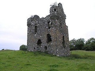
Dowhill Castle is a ruined castle in Perth and Kinross, Scotland. Sited on a hill near Loch Leven, the oldest part of the castle was built in around 1500 as a tower house. The main structure was extended in around 1600 with additional living space, as well as a tower and turret. The castle had a fortified courtyard (barmkin) to the north with a separate tower. There were probably four storeys but only two still survive.


