
Holkham National Nature Reserve is England's largest national nature reserve (NNR). It is on the Norfolk coast between Burnham Overy Staithe and Blakeney, and is managed by Natural England with the cooperation of the Holkham Estate. Its 3,900 hectares comprise a wide range of habitats, including grazing marsh, woodland, salt marsh, sand dunes and foreshore. The reserve is part of the North Norfolk Coast Site of Special Scientific Interest, and the larger area is additionally protected through Natura 2000, Special Protection Area (SPA) and Ramsar listings, and is part of both an Area of Outstanding Natural Beauty (AONB) and a World Biosphere Reserve. Holkham NNR is important for its wintering wildfowl, especially pink-footed geese, Eurasian wigeon and brant geese, but it also has breeding waders, and attracts many migrating birds in autumn. Many scarce invertebrates and plants can be found in the dunes, and the reserve is one of the only two sites in the UK to have an antlion colony.

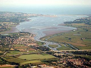
Millom is a town and civil parish on the north shore of the estuary of the River Duddon in southernmost Cumberland, Cumbria, England. It is situated just outside the Lake District National Park, about six miles north of Barrow-in-Furness and 26 mi (42 km) south of Whitehaven.

The Swale is a tidal channel of the Thames estuary that separates the Isle of Sheppey from the rest of Kent. On its banks is a 6,509.4-hectare (16,085-acre) biological Site of Special Scientific Interest which stretches from Sittingbourne to Whitstable in Kent. It is also a Ramsar internationally important wetland site and a Special Protection Area under the European Union Directive on the Conservation of Wild Birds. Parts of it are a Nature Conservation Review site, Grade I, National Nature Reserves, a Kent Wildlife Trust nature reserve and a Local Nature Reserve.

Loch Fleet is a sea loch on the east coast of Scotland, located between Golspie and Dornoch. It forms the estuary of the River Fleet, a small spate river that rises in the hills east of Lairg. The loch was designated a National Nature Reserve (NNR) in 1998, and is managed by a partnership between NatureScot, the Scottish Wildlife Trust (SWT) and Sutherland Estates. The NNR extends to 1058 hectares, including the Loch Fleet tidal basin, sand dunes, shingle ridges and the adjacent pine woods, including Balbair Wood and Ferry Wood. The tidal basin of the loch covers over 630 ha, and forms the largest habitat on the NNR.

Gibraltar Point national nature reserve is an area of about 4.3 km2 (1.7 sq mi) on the coast of Lincolnshire, England.
Foulney Island is a low-lying grass and shingle area 1 mile (1.6 km) to the south-east of Roa Island, off the southern tip of the Furness Peninsula in Cumbria, England. Foulney Island is one of the Islands of Furness in Morecambe Bay, northern England. For local government purposes the island is in the borough of Barrow-in-Furness. It has an area of about 40 acres. In earlier times it was known as Fowle Island.
The Blackwater Estuary is the estuary of the River Blackwater between Maldon and West Mersea in Essex. It is a 5,538 hectare biological Site of Special Scientific Interest (SSSI). An area of 4,395 hectares is also designated a Ramsar Wetland of International Importance, and a Special Protection Area 1,099 hectares is a National Nature Reserve. Tollesbury Wick and part of Abbotts Hall Farm, both nature reserve managed by the Essex Wildlife Trust, are in the SSSI.
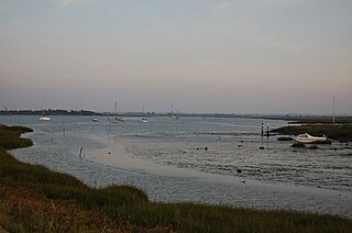
The Exe estuary is an estuary on the south coast of Devon, England.

The Ribble and Alt Estuaries lie on the Irish Sea coast of the ceremonial counties of Lancashire and Merseyside in the traditional county of Lancashire in north-west England, and form the boundaries of a number of conservation schemes.

The Blackwater or Munster Blackwater is a river which flows through counties Kerry, Cork and Waterford in Ireland. It rises in the Mullaghareirk Mountains in County Kerry and then flows in an easterly direction across County Cork through the towns of Mallow and Fermoy. It then enters County Waterford where it flows through Lismore, before abruptly turning south at Cappoquin and finally draining into the Celtic Sea at Youghal Harbour in Cork. In total, the Blackwater is 169 km (105 mi) long.

The Ythan Estuary is the tidal component of the Ythan River, emptying into the North Sea 19 kilometres (12 mi) north of Aberdeen, Scotland. The estuary’s tidal action extends a 7 kilometres (4.3 mi) inland and has characteristic widths of between 250 metres (820 ft) and 780 metres (2,560 ft). Besides the tidal channel there are interfaces to the upland dunes including mudflats, sand beaches and shingle flats. Reaches of salt marsh occur, but they are primarily near the Waterside Bridge and the mouth of the Tarty Burn, a small tributary river. Based upon the habitat of the moorland bordering the east of the Ythan River near the mouth, this estuary is the most significant coastal moorland in the northern United Kingdom.

Hodbarrow RSPB Reserve is a nature reserve run by the Royal Society for the Protection of Birds (RSPB) on the edge of the Lake District National Park in Cumbria, England. It is on the Duddon Estuary near the town of Millom and covers an area of 3.28 hectares.

Havergate Island is the only island in the county of Suffolk, England. It is found at the confluence of the River Ore and the Butley River near the village of Orford. It is a marshy nature reserve run by the Royal Society for the Protection of Birds (RSPB) and is known for its population of pied avocets and terns. It is part of the ecologically important Alde-Ore Estuary and has protected conservation status as part of a national nature reserve, SSSI, SAC, SPA, Ramsar Site and is also a part of the Suffolk Coast and Heaths AONB.

North Walney Nature Reserve is a national nature reserve on Walney Island, England. The reserve, which has an area of 646.5 ha, is notable as a habitat of natterjack toads. It is one of the sites in the Duddon Estuary which support one-fifth of the national population of the rare amphibian.

South Walney is one of two nature reserves on Walney Island, England. The nature reserve has an area of 130 ha leased from Holker estates. It has been managed by the Cumbria Wildlife Trust since 1963. The reserve is notable for:

Sandscale Haws is a national nature reserve on the Duddon Estuary, Cumbria, England. It is managed by the National Trust. Resident species include the natterjack toad.

Roanhead refers to the limestone outcrop of Roanhead Crag in Cumbria and the farmland behind it, but in recent years the term has been taken to mean the sandy beaches adjoining Sandscale Haws extending to Snab Point. The Irish Sea lies to the west of Roanhead, whilst the Duddon Estuary and Walney Channel are due north and south respectively. The beach is noted for its abundance of sand dunes and strong, often dangerous coastal currents. Today the beach is a National Trust conservation area, and a two-mile stretch of the Cumbria Coastal Way runs through it.

The North Norfolk Coast Site of Special Scientific Interest (SSSI) is an area of European importance for wildlife in Norfolk, England. It comprises 7,700 ha (19,027 acres) of the county's north coast from just west of Holme-next-the-Sea to Kelling, and is additionally protected through Natura 2000, Special Protection Area (SPA) listings; it is also part of the Norfolk Coast Area of Outstanding Natural Beauty (AONB). The North Norfolk Coast is also designated as a wetland of international importance on the Ramsar list and most of it is a Biosphere Reserve.

South Thames Estuary and Marshes is a 5,289-hectare (13,070-acre) biological Site of Special Scientific Interest which stretches between Gravesend and the mouth of the River Medway in Kent. Part of it is a Nature Conservation Review site, Grade I, and part is a Royal Society for the Protection of Birds nature reserve. It is part of the Thames Estuary and Marshes Ramsar internationally important wetland site and Special Protection Area under the European Union Directive on the Conservation of Wild Birds.

Hurst Castle and Lymington River Estuary is a 1,077.3-hectare (2,662-acre) biological and geological Site of Special Scientific Interest near Lymington in Hampshire. It is a Nature Conservation Review site and two areas are Geological Conservation Review sites. Three areas are local nature reserves, Boldre Foreshore, Sturt Pond and Lymington and Keyhaven Marshes; the latter site is managed by the Hampshire and Isle of Wight Wildlife Trust. Part of it is North Solent National Nature Reserve. It is part of Solent and Southampton Water Ramsar site and Special Protection Area. Parts of it are in Solent Maritime and Solent and Isle of Wight Lagoons Special Areas of Conservation.
