
Mandela was a proposed city that would have been formed as a result of some districts seceding from Boston, Massachusetts.

Roxbury is a neighborhood within the city of Boston, Massachusetts.
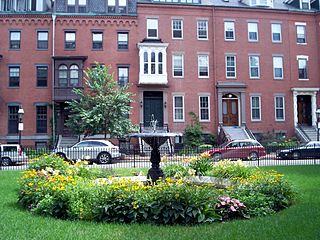
The South End is a neighborhood of Boston, Massachusetts. It is bordered by Back Bay, Chinatown, and Roxbury. It is distinguished from other neighborhoods by its Victorian style houses and the many parks in and around the area. The South End is the largest intact Victorian row house district in the country, as it is made up of over 300 acres. Eleven residential parks are contained within the South End. In 1973, the South End was listed in the National Register of Historic Places. Much of the South End was originally marshlands in Boston's South Bay. After being filled in, construction of the neighborhood began in 1849.
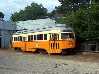
Mattapan is a neighborhood in Boston, Massachusetts. Historically a section of neighboring Dorchester, Mattapan became a part of Boston when Dorchester was annexed in 1870. As of the 2010 census, it had a population of 36,480, with the majority of its population immigrants. Like other neighborhoods of the late 19th and early 20th century, Mattapan developed, residentially and commercially, as the railroads and streetcars made downtown Boston increasingly accessible. Predominantly residential, Mattapan is a mix of public housing, small apartment buildings, single-family houses, and two- and three-family houses. Blue Hill Avenue and Mattapan Square, where Blue Hill Avenue, River Street, and Cummins Highway meet, are the commercial heart of the neighborhood, home to banks, law offices, restaurants, and retail shops. The new Mattapan Branch of the Boston Public library opened 2009, at a cost of more than $4 million. Mattapan has a large portion of green space within the neighborhood. The Harambee Park, the Franklin Park Zoo, the Boston Nature Center and Wildlife Sanctuary, Clark-Cooper Community Gardens, and historic Forest Hill Cemetery can all be considered green space within the neighborhood of Mattapan. Mattapan's demographics are diverse, with a large population of Haitians, Caribbean immigrants, and African Americans. Mattapan has public services such as a recently renovated community health center, and constable services. Mattapan has a trolley running through it, which is accessible via Ashmont.

Hyde Park is the southernmost neighborhood of Boston, Massachusetts, United States. Situated 7.9 miles south of downtown Boston, it is home to a diverse range of people, housing types and social groups. It is an urban location with suburban characteristics.

Chinatown, Boston is a neighborhood located in downtown Boston, Massachusetts. It is the only surviving historic ethnic Chinese enclave in New England since the demise of the Chinatowns in Providence, Rhode Island and Portland, Maine after the 1950s. Because of the high population of Asians and Asian Americans living in this area of Boston, there is an abundance of Chinese and Vietnamese restaurants located in Chinatown. It is one of the most densely populated residential areas in Boston and serves as the largest center of its East Asian and Southeast Asian cultural life. Chinatown borders the Boston Common, Downtown Crossing, the Washington Street Theatre District, Bay Village, the South End, and the Southeast Expressway/Massachusetts Turnpike. Boston's Chinatown is one of the largest Chinatowns outside of New York City.
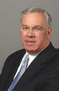
Thomas Michael Menino was an American politician who served as the 53rd mayor of Boston, Massachusetts from 1993 to 2014. He was the city's longest-serving mayor. Before becoming mayor, the Boston native was a member and President of the Boston City Council.

Boston's diverse neighborhoods serve as a political and cultural organizing mechanism. The City of Boston's Office of Neighborhood Services has designated 23 Neighborhoods in the city:

Mission Hill is a ¾ square mile, primarily residential neighborhood of Boston that borders Roxbury, Jamaica Plain, Brookline and Fenway-Kenmore. It is home to several hospitals and universities, including Brigham and Women's Hospital and New England Baptist Hospital. Mission Hill is known for its brick row houses and triple decker homes of the late 19th century. The population was estimated at 15,883 in 2011.

The Food Project is a non-profit organization that employs teenagers on farms in Lincoln, Roxbury and the North Shore of Massachusetts. It focuses on community improvement and outreach, and education about health, leadership, charity, and sustainable agriculture. The youth are recruited from urban areas of Boston, Lynn, and surrounding suburbs to plant and harvest crops for sale at Farmers' Markets and CSAs, and donation to local hunger-relief organizations and homeless shelters. The program emphasizes community building and fosters good work ethic, providing a good foundation for future employment.

Nubian Square is the primary commercial center of the Roxbury neighborhood of Boston, Massachusetts, located at the intersection of Dudley Street and Washington Street. It has long been the center of African American culture in Boston, prior to which the area was primarily Jewish.

Uphams Corner, or Upham's Corner, is a commercial center in Dorchester, the largest neighborhood of Boston, Massachusetts. The intersection of Dudley Street/Stoughton Street and Columbia Road is the heart of Uphams Corner, and one of Dorchester's main business districts.
Nelson Merced is a Massachusetts Latino activist and politician. He was the first Hispanic elected to the Massachusetts General Court, serving from 1989 to 1993 as Democratic representative from the fifth Suffolk District in Boston, including the Roxbury and North Dorchester neighborhoods.
Freedom House is a nonprofit community-based organization in Roxbury, Massachusetts. Freedom House is located in an area sometimes referred to as Grove Hall that lies along Blue Hill Ave. at the border between the Roxbury and Dorchester neighborhoods of Boston. Although it was historically identified with Roxbury, Freedom House currently refers to itself as being located either in Dorchester or in Grove Hall.
The Seaport District, or simply the Seaport, is a neighborhood in Boston, Massachusetts. It is sometimes considered part of South Boston and has gone under an extensive redevelopment effort in recent years. It is bordered by the Fort Point Channel to the west, Boston Harbor to the north and east, and South Boston to the south. It is sometimes referred to as The Boston Waterfront.

Whittier Street Health Center is a Federally Qualified Health Center that provides primary care and support services to primarily low-income, racially and ethnically diverse populations mostly from the Roxbury, Dorchester, Mattapan, and the South End neighborhoods of Boston, Massachusetts.
La Alianza Hispana is a social service agency founded in 1969 by residents of Roxbury/ North Dorchester to support Boston's Hispanic population. La Alianza advocates for equal access to services and public resources for the Hispanic Community by combating the effects of discrimination, poverty and challenges of migration.
Clarence “Jeep” Jones was an American community activist who was closely tied to the Roxbury neighborhood of Boston throughout his personal and professional life. Jones was the first African-American Deputy Mayor of the city of Boston. He had a 32-year career with the Boston Redevelopment Authority, serving as the Chairman of the board for 24 years.

The Bay State Banner is an independent newspaper primarily geared toward the readership interests of the African-American community in Boston, Massachusetts. The Bay State Banner was founded in 1965 by Melvin B. Miller who remains the chief editor and publisher. In 2015, the publication celebrated its 50th anniversary serving the region's minority-oriented neighborhoods.

Washington Gateway Main Street (WGMS) is a 501(c)(3) business development and neighborhood improvement organization. WGMS's mission is to develop and sustain the economic vitality of the commercial and residential neighborhoods along Washington Street in the South End and Lower Roxbury.
