
Bass Strait is a sea strait separating Tasmania from the Australian mainland, specifically the state of Victoria.

The Adelaide River is a river in the Northern Territory of Australia.

Melville Island is an island in the eastern Timor Sea, off the coast of the Northern Territory, Australia. Along with Bathurst Island and nine smaller uninhabited islands, it forms part of the group known as the Tiwi Islands, which are under the jurisdiction of the Northern Territory in association with the Tiwi Land Council as the regional authority.

The Tiwi Islands are part of the Northern Territory, Australia, 80 km (50 mi) to the north of Darwin adjoining the Timor Sea. They comprise Melville Island, Bathurst Island, and nine smaller uninhabited islands, with a combined area of 8,320 square kilometres (3,212 sq mi).

The Arafura Sea lies west of the Pacific Ocean, overlying the continental shelf between Australia and Indonesian New Guinea.
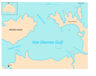
Van Diemen Gulf is a gulf in the Northern Territory of Australia which connects to the Timor Sea in the north via Dundas Strait. It is also connected to the Beagle Gulf in the west by the Clarence Strait. It covers an area of about 14,000 square kilometres (5,400 sq mi).
Clarence Strait in northern Australia separates Melville Island from the mainland of Australia. It also connects the Beagle Gulf in the west to the Van Diemen Gulf in the east. It is approximately 50 km (31 mi) north of the city of Darwin.
Marchinbar Island is the largest island in the Wessel Islands in the Northern Territory of Australia in the Arafura Sea.
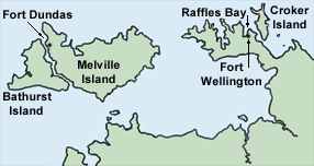
Fort Dundas was a short-lived British settlement on Melville Island between 1824 and 1828 in what is now the Northern Territory of Australia. It was the first of four British settlement attempts in northern Australia before Goyder's survey and establishment of Palmerston, now known as Darwin. The three later attempts were at Fort Wellington, Port Essington and Escape Cliffs.

Sailing Directions are written directions that describe the routes to be taken by boats and ships during coastal navigation and port approaches. There are also products known as Sailing Directions, which are books written by various Hydrographic Offices throughout the world. They are known as Pilot Books, because they provide local knowledge of routes and landmarks, which would typically be provided by a local marine pilot. As such, they are used frequently by naval and government vessels, who are exempted from 'Compulsory Pilotage' in many ports.

The Endeavour Strait is a strait running between the Australian mainland Cape York Peninsula and Prince of Wales Island in the extreme south of the Torres Strait, in northern Queensland, Australia. It was named in 1770 by explorer James Cook, after his own vessel, HMS Endeavour, and he used the strait as passage out to the Indian Ocean on his voyage.
Land councils, also known as Aboriginal land councils, or land and sea councils, are Australian community organisations, generally organised by region, that are commonly formed to represent the Indigenous Australians who occupied their particular region before the arrival of European settlers. They have historically advocated for recognition of traditional land rights, and also for the rights of Indigenous people in other areas such as equal wages and adequate housing. They are created under the Aboriginal Land Rights Act 1976.
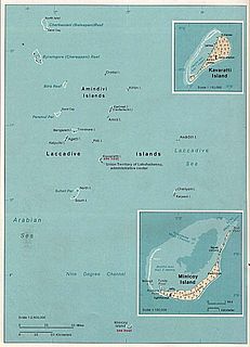
The Nine Degree Channel is a channel in the Indian Ocean between the Laccadive Islands of Kalpeni and Suheli Par, and Maliku Atoll. These two subgroups of islands, together with the Amindivi Subgroup, form the Indian Union Territory (UT) of Lakshadweep.
Duncan Passage is a strait in the Indian Ocean. It is about 48 km (30 mi) wide; it separates Rutland Island to the north, and Little Andaman to the south. West of Duncan Passage is the Bay of Bengal; east is the Andaman Sea. It lies within the exclusive economic zone of India protected by the integrated tri-services Andaman and Nicobar Command of Indian Military.

Escape Cliffs is a place on the northern coast of the Northern Territory of Australia and the site of the fourth of a series of four failed attempts to establish permanent settlement in Australia's Top End. The previous attempts were at Fort Dundas, Fort Wellington and Port Essington. Escape Cliffs lies on the western coast of the Cape Hotham peninsula, and the eastern shore of Adam Bay, near the mouth and estuary of the Adelaide River. It lies about 60 km north-east of Darwin and is located in the Cape Hotham sector of the Djukbinj National Park. There is no road access, though it is sometimes visited by yachts.

Beagle Gulf is a gulf in the Northern Territory of Australia which opens on its west side to the Timor Sea. The gulf is bounded to the south by the mainland and to the north by Bathurst and Melville Islands. It is connected to Van Diemen Gulf in the east by Clarence Strait. Its south coast includes the natural harbours of Darwin and Bynoe. It is approximately 100 km long and 50 km wide. It surrounds the Quail Island Group.

Troubridge Point is a headland in the Australian state of South Australia located on the south coast of Yorke Peninsula about 11 kilometres south west of Edithburgh. It is the western end of the opening to Gulf St Vincent.

The Nicholson River is a river located in the Northern Territory and the state of Queensland, Australia.

Vernon Islands is a locality in the Northern Territory of Australia located over land and water in the Clarence Strait including the Vernon Islands and which is located about 55 kilometres (34 mi) north-east of the territory capital of Darwin.

Vernon Islands, also known as the Potinga Islands, is an island group in the Northern Territory of Australia located in the Clarence Strait about 55 kilometres (34 mi) north-east of the territory capital of Darwin. The group consists of three islands which were first sighted in 1818 by Europeans on a British navy ship under the command of Phillip Parker King. The group were part of the subject of a successful aboriginal land claim which was resolved after 40 years in 2018 when the Tiwi people received title. All three islands host navigation aids which assist vessels passing through the Clarence Strait. It and some adjoining seabed have had protected area status since 1974 and which has been known as the Vernon Islands Conservation Reserve since 1979. Since 2007, the island group have been located in the locality of Vernon Islands.

