Dungarpur is the seat of the elder branch of the Guhilot of Mewar family. The seat of the younger branch is that of the Maharana of Udaipur. The city was founded in 1282 A.D. by Rawal Veer Singh, who was the eldest son of the ruler of Mewar, Karan Singh.[2] They are descendants of Bappa Rawal, eighth ruler of the Guhilot dynasty and founder of the Mewar dynasty (r. 734–753).
The chiefs of Dungarpur bear the title of Maharawal as they are descendants of Mahup, the eldest son of Karan Singh, the chief of Mewar in the 12th century, and claim the honors of the elder line of Mewar. Mahup, disinherited by his father, took refuge with his mother's family, the Chauhans of Bagar[3] and made himself lord of that country at the expense of the Bhil chiefs.[4] His younger brother, Rahup, founded a separate Sisodia dynasty.[citation needed]
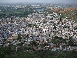
Temple Dev SomnathTwo River Bridge, Dungarpur
The town of Dungarpur, the capital of the state, was founded near the end of the 14th century by Rawal Bir Singh, the sixth descendant of Sawant Singh of Mewar, who named it after Dungaria, an independent Bhilchieftain who was assassinated. After the death of Rawal Udai Singh of Bagar at the Battle of Khanwa in 1527, where he fought alongside Rana Sanga against Babar, his territories were divided into the states of Dungarpur and Banswara.[4] Successively under Mughal, Maratha and British Raj control by treaty in 1818, it remained a 15-gun salute state.[5]
In 1901, the total population of Dungarpur was 100,103, while that of the town was 6094. The last princely ruler of Dungarpur was Rai-i-Rayan Maharawal Shri Lakshman Singh Bahadur (1918–1989), who was awarded the KCSI (1935) and GCIE (1947), and after independence became a Member of the Rajya Sabha twice, in 1952 and 1958, and later a member of Rajasthan Legislative Assembly (MLA) in 1962 and 1989.[2]
Demographics
As of 2011[update]India census, Dungarpur had a population of 47,706 people. The population consists of 52% males and 48% females.[6] Dungarpur has an average literacy rate of 76%, higher than the national average of 59.5%. The male literacy rate is 83%, and the female literacy rate is 69%. In Dungarpur, 13% of the population is under 6 years of age.
The climate of Dungarpur is quite dry. The summer season is hot, but milder than most of the other Rajasthan cities. The average temperature in summer falls in the range of 43°C (max) to 26°C (min). The winter season is fairly cool. The average temperature ranges between 25°C (max) to 9°C (min). The average annual rainfall for Dungarpur hovers between 47cm to 76cm. The mean temperature in Durgapur is 23°C in November with a humidity of 68%.[7]
Dungarpur Rajya ka Itihasa (History: Kingdom of Dungarpur), by Gaurishankar Hirachand Ojha, First published 1936. Publisher: Rajasthani Granthaghar, Jodhpur 2000. ISBN81-87720-01-8.
This page is based on this Wikipedia article Text is available under the CC BY-SA 4.0 license; additional terms may apply. Images, videos and audio are available under their respective licenses.


