
Lismore is a city in northeastern New South Wales, Australia and the main population centre in the City of Lismore local government area; it is also a regional centre in the Northern Rivers region of the State. It is situated on a low flood plain on the banks of the Wilsons River near the latter's junction with Leycester Creek, both tributaries of the Richmond River which enters the Pacific Ocean at Ballina, 30 km (19 mi) to the east. The original settlement initially developed as a grazing property in the 1840s, then became a timber and agricultural town and inland port based around substantial river traffic, which prior to the development of the road and rail networks was the principal means of transportation in the region. Use of the river for transport declined and then ceased around the mid-twentieth century, however by that time Lismore had become well established as the largest urban centre in the region, providing its surrounding area with a range of services. The city is also located on the Bruxner Highway which crosses the Wilsons River at Lismore, and was formerly a stop on the Casino-Murwillumbah railway line. It is the home of one of the three campuses of Southern Cross University.

Northern Rivers is the most north-easterly region of the Australian state of New South Wales, located between 590 and 820 kilometres north of the state capital, Sydney, and encompasses the catchments and fertile valleys of the Clarence, Richmond, and Tweed rivers. It extends from Tweed Heads in the north to the southern extent of the Clarence river catchment which lies between Grafton and Coffs Harbour, and includes the main towns of Tweed Heads, Byron Bay, Ballina, Kyogle, Lismore, Casino and Grafton. At its most northern point, the region is 102 kilometres (63 mi) south-southeast of the Queensland capital, Brisbane.

Ballina is a town in the Northern Rivers region of New South Wales, Australia, and the seat of the Ballina Shire local government area. Ballina's urban population at June 2018 was 26,381. The town lies on the Richmond River and serves as a gateway to Byron Bay.

Longford is a town in the northern midlands of Tasmania, Australia. It lies 145 m above sea level at the convergence of the Macquarie River and the South Esk River, 21 km south of Launceston and a 15-minute drive from the airport. It is just south of the Illawarra Road, a road connecting the Bass and Midland Highways. It has a population of 3,863 and is part of the Northern Midlands Council area. The region is predominantly agricultural, noted for wool, dairy produce and stock breeding.

Nimbin is a village in the Northern Rivers area of the Australian state of New South Wales, approximately 30 km (19 mi) north of Lismore, 33 km (21 mi) northeast of Kyogle, and 70 km (43 mi) west of Byron Bay.

Casino is a town in the Northern Rivers area of New South Wales, Australia, with a population of 10,914 people at the 2016 census. It lies on the banks of the Richmond River and is situated at the junction of the Bruxner Highway and the Summerland Way.

The City of Hawkesbury is a local government area of New South Wales, Australia, part of which is at the fringe of the Sydney metropolitan area, about 50 kilometres (31 mi) north-west of the Sydney central business district. Hawkesbury City is named after the Hawkesbury River.
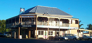
Coraki is a small town that sits on the confluence of the Richmond and Wilson Rivers in northern New South Wales, Australia in Richmond Valley Shire. At the 2016 census, Coraki had a population of 1,277 people.
Modanville is a scattered community in New South Wales, Australia, situated 14 kilometres (9 mi) north of the city of Lismore. At the 2006 census, it had a population of 515 people.
Wingecarribee Shire is the local government area of the Southern Highlands in the state of New South Wales, Australia. The Wingecarribee Shire is around 110 kilometres (70 mi) southwest of the Sydney central business district and is part of regional Capital Country and to some extent can be considered part of the Southern Tablelands.

Seisia is a coastal town and a locality in the Northern Peninsula Area Region, Queensland, Australia. In the 2016 census, Seisia had a population of 260 people.

Injinoo is a coastal town in the Northern Peninsula Area Region and a locality split between Northern Peninsula Area Region and the Shire of Torres in Far North Queensland, Australia. It is on the north-western coast of Cape York Peninsula. In the 2016 census, Injinoo had a population of 561 people.

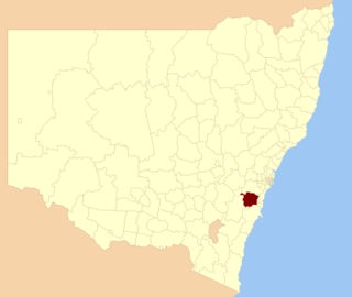
The City of Lismore is a local government area in the Northern Rivers region of New South Wales, Australia. The seat of the local government area is Lismore, a major regional centre of the state.
Kin Kin is a rural town and locality in the Shire of Noosa, Queensland, Australia. In the 2016 census, the locality of Kin Kin had a population of 764 people. In the 2021 census the population had risen to 844.

Jugiong is a locality and town on the banks of the Murrumbidgee River near its confluence with Jugiong Creek. in the Hilltops Council Local Government area, New South Wales, Australia. It is situated just off the Hume Highway, by road, about 30 kilometres southwest from Bookham and 40 kilometres northeast from Gundagai.

Rous County is one of the 141 Cadastral divisions of New South Wales. It is located at the north-east tip of the state. It is bordered on the north by the border with Queensland and on the south by the Richmond River. It contains Lismore, Byron Bay and Murwillumbah.

Wilsons River, a perennial river and part of the Richmond River catchment, is situated in the Northern Rivers district of New South Wales, Australia.
Rappville is a small village in northern New South Wales, Australia. At the 2016 census, Rappville recorded a population of 169 people.

Wardell is a village in the Northern Rivers region of New South Wales, Australia. It is situated on the Richmond River and the Pacific Highway between Broadwater and Ballina. Wardell is approximately 724 km (450 mi) north of Sydney and 200 km (124 mi) south of Brisbane. The boundaries are within the Ballina Shire local government area.
Wyangala is a small village in the Lachlan Valley, near the junction of the Abercrombie and Lachlan Rivers, just below the Wyangala Dam wall. It is in the South West Slopes of New South Wales, Australia, and about 320 km (200 mi) west of the state capital, Sydney.

