The Suffolk Coast Path is a long-distance footpath along the Suffolk Heritage Coast in England. It is 50 miles (80 km) long.

The Suffolk Coast and Heaths AONB is an Area of Outstanding Natural Beauty in Suffolk and Essex, England.
Knettishall Heath is a 91.7-hectare (227-acre) biological Site of Special Scientific Interest west of Knettishall in Suffolk. A larger area of 176 hectares is the Knettishall Heath Nature Reserve, which is managed by the Suffolk Wildlife Trust.

RSPB Minsmere is a nature reserve owned and managed by the Royal Society for the Protection of Birds (RSPB) at Minsmere, Suffolk. The 1,000-hectare (2,500-acre) site has been managed by the RSPB since 1947 and covers areas of reed bed, lowland heath, acid grassland, wet grassland, woodland and shingle vegetation. It lies within the Suffolk Coast and Heaths Area of Outstanding Natural Beauty and the Suffolk Heritage Coast area. It is conserved as a Site of Special Scientific Interest, Special Area of Conservation, Special Protection Area and Ramsar site.

Suffolk Wildlife Trust (SWT) describes itself as the county's "nature charity – the only organisation dedicated wholly to safeguarding Suffolk's wildlife and countryside." It is a registered charity, and its headquarters is at Brooke House in Ashbocking, near Ipswich. It was founded in 1961, and is one of 46 wildlife trusts covering the Great Britain and Northern Ireland. As of March 2017, it has 13,200 members, and it manages 3,120 hectares of land in 60 nature reserves, most of which are open to the public. It had an income of £3.9 million in the year to 31 March 2017.
Minsmere is a place in the English county of Suffolk. It is located on the North Sea coast around 3.5 miles (5.6 km) north of Leiston and 1.5 miles (2.4 km) south-east of Westleton within the Suffolk Coast and Heaths AONB. It is the site of the Minsmere RSPB reserve and the original site of Leiston Abbey.

Westleton is a village and civil parish in the English county of Suffolk. It is located 4 miles (6 km) north of Leiston and 5 miles (8 km) north-east of Saxmundham near the North Sea coast. The village is on the edge of the Suffolk Sandlings, an area of lowland heathland. The village lies along the B1125 road, 2 miles (3 km) to the east of the A12 and Darsham railway station.

Breckland in Norfolk and Suffolk is a 39,433 hectare Special Protection Area (SPA) under the European Union Directive on the Conservation of Wild Birds. The SPA partly overlaps the 7,544 hectare Breckland Special Area of Conservation. As a landscape region it is an unusual natural habitat of England. It comprises the gorse-covered sandy heath that lies mostly in the south of the county of Norfolk but also in the north of Suffolk. An area of considerable interest for its unusual flora and fauna, it lies to the east of another unusual habitat, the Fens, and to the south west of the Broads. The typical tree of this area is the Scots pine. Breckland is one of the driest areas in England.
The Sandlings Walk is a long-distance path in Suffolk, England. It runs 91.6km through the Suffolk Sandling that used to stretch from the outskirts of Ipswich to Southwold which is an area of lowland heath, Britain's rarest wildlife habitat, and the Suffolk Coast and Heaths Area of Outstanding Natural Beauty.

Alde–Ore Estuary is a 2,534 hectare biological and geological Site of Special Scientific Interest which stretches along the Suffolk coast between Aldeburgh and Bawdsey, and also includes parts of the Alde, Ore and Butley Rivers. It is in the Suffolk Coast and Heaths Area of Outstanding Natural Beauty, and is a Grade I Nature Conservation Review site, a Special Area of Conservation, a Ramsar internationally important wetland site, and a Special Protection Area under the European Union Directive on the Conservation of Wild Birds. It includes two Geological Conservation Review sites, "Orfordness and Shingle Street" and "The Cliff, Gedgrave", and two nature reserves managed by the Suffolk Wildlife Trust, Alde Mudflats and Simpson's Saltings. The coastal part of the site is Orfordness-Havergate, a National Nature Reserve, and Orford Ness is managed by the National Trust, while Havergate Island is managed by the Royal Society for the Protection of Birds.

North Warren RSPB reserve is a nature reserve run by the Royal Society for the Protection of Birds (RSPB) in Suffolk, England. It lies on the Suffolk coast on the north edge of the town of Aldeburgh and to the south of Thorpeness and includes the Aldringham Walks area of heathland to the north. It is within the Suffolk Coast and Heaths Area of Outstanding Natural Beauty (AONB) and the Suffolk Heritage Coast area. Noted for its populations of Eurasian bittern, European nightjar and other bird species, it covers a range of coastal habitats and is protected with SSSI, SPA conservation status.

Treen Cliff is a Site of Special Scientific Interest (SSSI) located on the Penwith Peninsula in Cornwall, England, UK, 6 miles (9.7 km) south-west of Penzance. First notified in 1951, with a revision in 1973, and a further notification on 1 July 1986, it is 49.3 hectares in area, stretching from grid reference SW387220 to SW402225. Designated for both for its biological and geological interest, part of the site, Treryn Dinas, is a Scheduled Ancient Monument consisting of a "cliff castle" with four ramparts and ditches and the Logan Rock. It is within the Cornwall Area of Outstanding Natural Beauty (AONB), the Penwith Heritage Coast and is part owned and managed by the National Trust.
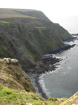
Steeple Point to Marsland Mouth is a coastal Site of Special Scientific Interest (SSSI) in Cornwall, England, UK, noted for its biological characteristics.

Blaxhall Common is a nature reserve in the parish of Blaxhall in the East Suffolk District of Suffolk. The reserve is owned by Blaxhall Parish Council and managed by Suffolk Wildlife Trust. It is designated a 45.9-hectare (113-acre) biological Site of Special Scientific Interest as Blaxhall Heath. It is part of the Sandlings Special Protection Area under the European Union Directive on the Conservation of Wild Birds, and of the Suffolk Coast and Heaths Area of Outstanding Natural Beauty. A Bronze Age bowl barrow is a Scheduled Monument.

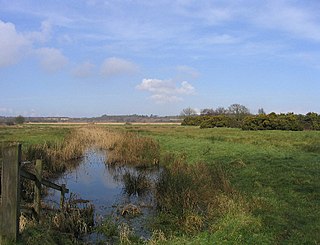
Dingle Marshes is a 93-hectare (230-acre) wildlife reserve on the North Sea coast of the English county of Suffolk. The reserve is located between Dunwich and Walberswick, approximately 4 miles (6.4 km) south-west of Southwold. The marshes make up part of the Suffolk Coast National Nature Reserve along with reserves at Walberswick and Hen Reedbeds. They are owned jointly by the RSPB and Suffolk Wildlife Trust and are managed by these two organisations and Natural England. The site is in the Dunwich Heaths and Marshes Nature Conservation Review site, Grade I, the Minsmere-Walberswick Ramsar internationally important wetland site, the Minsmere to Walberswick Heaths and Marshes Special Area of Conservation, and the Minsmere-Walberswick Special Protection Area under the European Union Directive on the Conservation of Wild Birds.

Dunwich Forest is an area of forest and lowland heath around 1 mile (1.6 km) north-west of the village of Dunwich in the English county of Suffolk. The forest covers an area of approximately 9 square kilometres and was originally planted by the Forestry Commission. The forest is within the Suffolk Coast and Heaths Area of Outstanding Natural Beauty and is in the area known as the Suffolk Sandlings. South of the reserve is the National Trust property of Dunwich Heath, one of the largest remaining areas of lowland heath on the Suffolk coast, and the RSPB reserve at Minsmere. To the north and east of the forest are Dingle Marshes, part of the Suffolk Coast National Nature Reserve.

Hen Reedbeds is a 55 hectare nature reserve near the North Sea coast of the English county of Suffolk. The reserve is located in the Blyth valley between Reydon and Blythburgh, approximately 2.5 miles (4.0 km) west of Southwold. The marshes make up part of the Suffolk Coast National Nature Reserve along with reserves at Walberswick and Dingle Marshes.

Suffolk Coast National Nature Reserve is a wildlife reserve on the North Sea coast of the English county of Suffolk. It is located around the village of Walberswick to the south of the town of Southwold. The reserve was designated in 2003, combining the existing Walberswick National Nature Reserve with reserves at Dingle Marshes and Hen Reedbeds to create a 1,340 hectares reserve.

Minsmere–Walberswick Heaths and Marshes are a Special Area of Conservation and Site of Special Scientific Interest in the English county of Suffolk. The site is located on the North Sea coast between Southwold and Sizewell, extending over an area of coastline around 7 miles (11 km) in length. The site is also designated as a Special Protection Area, part of the Minsmere–Walberswick European Marine Site and contains areas designated as Ramsar sites and Natura 2000 sites. It lies within the Suffolk Coast and Heaths Area of Outstanding Natural Beauty and is made up of a "complex mosaic" of marshes, reed beds, shingle banks and lowland heath habitats.

Tunstall Common is a 36.6 hectares biological Site of Special Scientific Interest east of Tunstall in Suffolk. It is part of the Sandlings Special Protection Area under the European Union Directive on the Conservation of Wild Birds, and the Suffolk Coast and Heaths Area of Outstanding Natural Beauty.
