
The Isle of Wight is a county and the largest and second-most populous island of England. It is in the English Channel, between two and five miles off the coast of Hampshire, from which it is separated by the Solent. Referred to as 'The Island' by residents, the island has resorts that have been holiday destinations since Victorian times, and is known for its mild climate, coastal scenery, and verdant landscape of fields, downland and chines. The island is historically part of Hampshire, and is designated a UNESCO Biosphere Reserve.
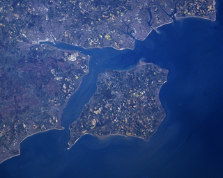
The Solent is a strait between the Isle of Wight and Great Britain. It is about 20 miles long and varies in width between 2+1⁄2 and 5 mi, although the Hurst Spit which projects 1+1⁄2 mi (2.4 km) into the Solent narrows the sea crossing between Hurst Castle and Colwell Bay to just over 1 mi (1.6 km).
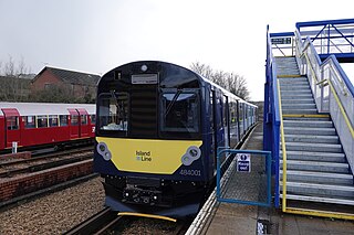
The Island Line is a railway line on the Isle of Wight which runs along the island's east coast and links Ryde Pier Head with Shanklin. Trains connect at Ryde Pier Head with passenger ferries to Portsmouth Harbour, and these ferries in turn connect with the rest of the National Rail network via the Portsmouth Direct Line. The line also connects to the Isle of Wight Steam Railway, a heritage railway, at Smallbrook Junction. For much of its length the line runs alongside the A3055, criss-crossing this road by means of the Ryde Tunnel and bridges at Rowborough, Morton Common, Lake Hill and Littlestairs.
Bembridge is a village and civil parish located on the easternmost point of the Isle of Wight. It had a population of 3,848 according to the 2001 census of the United Kingdom, leading to the implausible claim by some residents that Bembridge is the largest village in England. Bembridge is home to many of the Island's wealthiest residents. The population had reduced to 3,688 at the 2011 Census.

The ancient 'Kynges Towne' of Brading is the main town of the civil parish of the same name. The ecclesiastical parish of Brading used to cover about a tenth of the Isle of Wight. The civil parish now includes the town itself and Adgestone, Morton, Nunwell and other outlying areas between Ryde, St Helens, Bembridge, Sandown and Arreton. Alverstone was transferred to the Newchurch parish some thirty years ago.
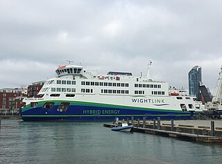
Wightlink is a ferry company operating routes across The Solent between Hampshire and the Isle of Wight in the south of England. It operates car ferries between Lymington and Yarmouth, and Portsmouth and Fishbourne and a fast passenger-only catamaran between Portsmouth Harbour and Ryde Pier. The company is jointly owned by Basalt Infrastructure Partners based in the United Kingdom and Fiera Infrastructure based in Canada.

Ryde Pier is an early 19th century pier serving the town of Ryde, on the Isle of Wight, off the south coast of England. It is the world's oldest seaside pleasure pier. Ryde Pier Head railway station is at the sea end of the pier, and Ryde Esplanade railway station at the land end, both served by Island Line trains.

St Helens is a village and civil parish located on the eastern side of the Isle of Wight.
As an island, the Isle of Wight maintains a culture close to, but distinct from, that of the south of England. A high proportion of the population are now 'overners' rather than locally born, and so with a few notable exceptions it has more often formed the backdrop for cultural events of wider rather than island-specific significance.

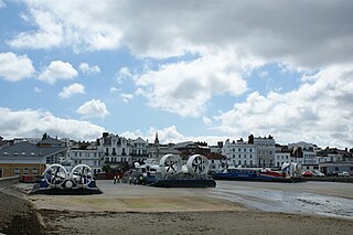
Seaview is a small Edwardian resort located on the north-eastern corner of the Isle of Wight, overlooking the Solent. The village is popular with tourists and is 2+1⁄3 miles (3.8 km) from the town of Ryde, where most tourists reach the island by ferry or hovercraft. Together with Nettlestone, it forms a civil parish of Nettlestone and Seaview.
There are currently three different ferry companies that operate vessels carrying passengers and, on certain routes, vehicles across the Solent, the stretch of sea that separates the Isle of Wight from mainland England. These are Wightlink, Red Funnel and Hovertravel.

The Isle of Wight Coastal Path is a circular long-distance footpath of 70 miles (113 km) around the Isle of Wight, UK. It follows public footpaths and minor lanes, with some sections along roads.

Haylands is an area just to the south of Ryde on the Isle of Wight, off the south coast of England. At the time of the 2011 Census the population etc. of Haylands is listed under Ryde. Located to the east, it is a short walk away from housing estates at Pell and Binstead. The settlement consists mainly of a housing development, including some ex-local authority housing, a corner shop in Upton Road, a primary and a middle school. It is not far from Ryde High School at Pell Lane. In the centre of Haylands there is a pub called Lake Huron. The pub's name originates from the Lake family, a 19th-century family of brewers who owned several pubs naming them after the Great Lakes of North America, Lake Huron is the only one to have survived. Haylands forms part of the local electoral ward of Havenstreet, Ashey and Haylands and at the Isle of Wight Council election in 2009 elected Independent councillor Vanessa Churchman. The settlement lies to the west of the A3055 road. Haylands is approximately 5.5 miles (8.9 km) north-east of Newport. Southern Vectis route 4 used to link the area with Ryde and East Cowes. However this caused the journey time to increase significantly and the area was later withdrawn from the service and after negotiations a limited replacement service was put in place. This service was later improved and is now run as route 37.

There once existed a 55+1⁄2-mile (89.3 km) network of railway lines on the Isle of Wight, which operated both as a self-contained railway network, and as links to ferry services between the island and the South coast of Great Britain. The routes were opened by several companies between 1862 and 1901 and modernised after The Grouping in the 1920s. Most of them were permanently closed between 1952 and 1966, whilst the 8+1⁄2-mile-long (13.7 km) Island Line was temporarily closed in 1966 and rebuilt for electric train services, introduced in 1967. Replacement trains were introduced in 1990, and again in 2021 along with a major renewal of the line. A further 5+1⁄2 miles (8.9 km) have reopened as a heritage line known as the Isle of Wight Steam Railway and there have been several proposals to expand the network further since the 1960s, either with conventional heavy rail or by conversion to light rail.

Puckpool is a small coastal settlement on the outskirts of Ryde on the Isle of Wight. The area is best known for Puckpool Park, a park with an 18-hole putting green, 12 hole mini golf and two tennis courts. Puckpool Battery is located within the boundaries of the park; this is an old Palmerston Fort built in 1865.

Thomas Hellyer was an English architect of the mid-Victorian era. He was based on the Isle of Wight and was "the leading Island-based architect of the period", but his works can also be found on the mainland—principally in Hampshire—but also further afield. Described by Pevsner as a "very individualistic" and "remarkable" architect, his output included churches, houses, schools and hospitals across the island, during a period of rapid urban development. Many of his buildings have listed status and he "made important contributions to the appearance of the city" of Portsmouth through his extensive work in the area.
