
Canterbury Cathedral in Canterbury, Kent, is one of the oldest and most famous Christian structures in England. It forms part of a World Heritage Site. It is the cathedral of the Archbishop of Canterbury, currently Justin Welby, leader of the Church of England and symbolic leader of the worldwide Anglican Communion. Its formal title is the Cathedral and Metropolitical Church of Christ at Canterbury.

Sandwich is a town and civil parish in the Dover District of Kent, south-east England. It lies on the River Stour and has a population of 4,985. Sandwich was one of the Cinque Ports and still has many original medieval buildings, including several listed public houses and gates in the old town walls, churches, almshouses and the White Mill. While once a major port, it is now two miles from the sea due to the disappearance of the Wantsum Channel. Its historic centre has been preserved. Sandwich Bay is home to nature reserves and two world-class golf courses, Royal St George's and Prince's. The town is also home to many educational and cultural events. Sandwich also gave its name to the food by way of John Montagu, 4th Earl of Sandwich, and the word sandwich is now found in several languages.
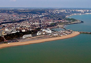
Folkestone is a port town on the English Channel, in Kent, south-east England. The town lies on the southern edge of the North Downs at a valley between two cliffs. It was an important harbour and shipping port for most of the 19th and 20th centuries.

Aldeburgh is a coastal town in the county of Suffolk, England. Located to the north of the River Alde. Its estimated population was 2,276 in 2019. It was home to the composer Benjamin Britten and remains the centre of the international Aldeburgh Festival of arts at nearby Snape Maltings, which was founded by Britten in 1948. It also hosts an annual poetry festival and several food festivals and other events. Aldeburgh, as a port, gained borough status in 1529 under Henry VIII. Its historic buildings include a 16th-century moot hall and a Napoleonic-era Martello Tower. A third of its housing consists of second homes. Visitors are drawn to its Blue Flag beach and fisherman huts, where fresh fish is sold, to Aldeburgh Yacht Club and to its cultural offerings. Two family-run fish and chip shops have been rated among the country's best. The independent Aldeburgh bookshop has been in business for over seventy years, is locally thought to have been the site of the birthplace of George Crabbe (1754-1832) and has organised the annual Aldeburgh Literary Festival since 2002.

Romney Marsh is a sparsely populated wetland area in the counties of Kent and East Sussex in the south-east of England. It covers about 100 square miles (260 km2). The Marsh has been in use for centuries, though its inhabitants commonly suffered from malaria until the 18th century. Due to its location, geography and isolation, it was a smuggler's paradise between the 1600s and 1800s. The area has long been used for sheep pasture: Romney Marsh sheep are considered one of the most successful and important sheep breeds. Criss-crossed with numerous waterways, and with some areas lying below sea level, the Marsh has over time sustained a gradual level of reclamation, both through natural causes and by human intervention.
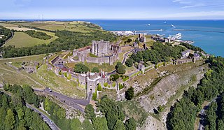
Dover Castle is a medieval castle in Dover, Kent, England and is Grade I listed. It was founded in the 11th century and has been described as the "Key to England" due to its defensive significance throughout history. Some writers say it is the largest castle in England, a title also claimed by Windsor Castle.
Hythe is a coastal market town on the edge of Romney Marsh, in the district of Folkestone and Hythe on the south coast of Kent. The word Hythe or Hithe is an Old English word meaning haven or landing place.

New Romney is a market town in Kent, England, on the edge of Romney Marsh, an area of flat, rich agricultural land reclaimed from the sea after the harbour began to silt up. New Romney, one of the original Cinque Ports, was once a sea port, with the harbour adjacent to the church, but is now more than a mile from the sea. A mooring ring can still be seen in front of the church. It is the headquarters of the Romney, Hythe and Dymchurch Railway.

Lydd is a town and electoral ward in Kent, England, lying on Romney Marsh. It is one of the larger settlements on the marsh, and the most southerly town in Kent. Lydd reached the height of its prosperity during the 13th century, when it was a corporate member of the Cinque Ports, a "limb" of Romney. Actually located on Denge Marsh, Lydd was one of the first sandy islands to form as the bay evolved into what is now called Romney Marsh.
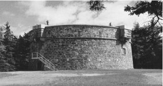
Martello towers, sometimes known simply as Martellos, are small defensive forts that were built across the British Empire during the 19th century, from the time of the French Revolutionary Wars onwards. Most were coastal forts.

St Osyth is an English village and civil parish in the Tendring District of north-east Essex, about 5 miles (8.0 km) west of Clacton-on-Sea and 12 miles (19.3 km) south-east of Colchester. It lies on the B1027, Colchester–Clacton road. The village is named after Osgyth, a 7th-century saint and princess. Locally, the name is sometimes pronounced "Toosey". It is claimed to be the driest recorded place in the United Kingdom.

Margate is a seaside town on the north coast of Kent in south-east England. The town is estimated to be 1.5 miles long, 16 miles north-east of Canterbury and includes Cliftonville, Garlinge, Palm Bay and Westbrook.

Dungeness is a headland on the coast of Kent, England, formed largely of a shingle beach in the form of a cuspate foreland. It shelters a large area of low-lying land, Romney Marsh. Dungeness spans Dungeness Nuclear Power Station, the hamlet of Dungeness, and an ecological site at the same location. It lies within the civil parish of Lydd.
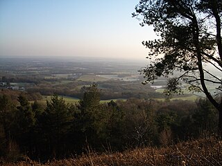
Leith Hill in southern England is the highest summit of the Greensand Ridge, approximately 6.7 km (4 mi) southwest of Dorking, Surrey and 40.5 km (30 mi) southwest of central London. It reaches 294 m (965 ft) above sea level, and is the second highest point in southeast England, after Walbury Hill in southwest Berkshire,. Leith Hill is the highest ground for 79 km (49 mi).

Hadlow Castle was an 18th-century country house in Hadlow, Kent, England, built in the fashionable Strawberry Hill 'Gothic' style. The house was gradually enlarged and extended during the 19th century and finally demolished in the 20th, apart from a prospect tower and ancillary buildings. The surviving Grade I Listed Hadlow Tower, locally known as May's Folly, was restored in 2013.

Dymchurch Grand Redoubt is a fortification at Palmarsh on the coast of Kent in England, built during the Napoleonic War as part of a large defensive scheme to protect the country from an expected French invasion.

Eastbourne Redoubt is a circular coastal defence fort at Eastbourne, East Sussex, on the south coast of England. It was built in 1805 as part of the British anti-invasion preparations during the Napoleonic Wars. The building is now owned by the local authority and is open to the public.
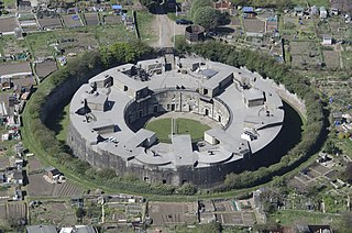
Harwich Redoubt is a circular fort built in 1808 to defend the port of Harwich, Essex from Napoleonic invasion. The Harwich Society opens it to the public.

Dymchurch is a village and civil parish in the Folkestone and Hythe district of Kent, England. The village is located on the coast five miles (8 km) south-west of Hythe, and on the Romney Marsh.

Grain Tower is a mid-19th-century gun tower situated offshore just east of Grain, Kent, standing in the mouth of the River Medway. It was built along the same lines as the Martello towers that were constructed along the British and Irish coastlines in the early 19th century and is the last-built example of a gun tower of this type. It owed its existence to the need to protect the important dockyards at Sheerness and Chatham from a perceived French naval threat during a period of tension in the 1850s.

