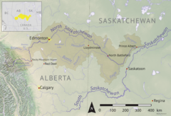
Wakaw Lake is a lake in the RM of Hoodoo No. 401 in the central part of the Canadian province of Saskatchewan. It is about 102 kilometres (63 mi) north-east of Saskatoon and 73 kilometres (45 mi) south of Prince Albert. It takes its name from a Cree word meaning "crooked", referring to the curved shape of the lake. The lake is known in Cree as ᐚᑳᐤ ᓵᑲᐦᐃᑲᐣ wâkâw sâkahikan. Wakaw Lake is the source of the Carrot River, which is a 300-kilometre (190 mi) long river that parallels the South Saskatchewan and Saskatchewan Rivers before meeting the Saskatchewan River at The Pas, Manitoba.
Morin Lake is a small lake north-west of Prince Albert in the Canadian province of Saskatchewan. It is a spring-fed, glacial lake situated in the Thickwood Hills and surrounded by boreal forests. From the north end of the lake, a short stream flows out and meets Big River.
Big River is a town located on the southern end of Cowan Lake in north central Saskatchewan, Canada. It is just north of Saskatchewan's extensive grain belt on Highway 55 and about 16 kilometres (10 mi) west of Prince Albert National Park. Delaronde Lake is accessed east of the town. Big River is approximately 132 kilometres (82 mi) from Prince Albert.

Waskesiu Lake is a lake located roughly in the centre of Prince Albert National Park. The lake's name means red deer or elk in the Cree language. Waskesiu Lake is by far the most developed lake in the park, and features a variety of recreational facilities along all sides of its shoreline, including camping, golfing, boating, and hiking. The resort village of Waskesiu Lake is on its eastern shore. The Prince Albert National Park Nature Centre is located in the village as well as many other amenities such as lodging, police, a gas station, shopping, and restaurants. Access to the lake is from Highways 263 and 264.
There are numerous heritages and cultural attractions in the province of Saskatchewan. Museums, dinosaur digs, aboriginal cultural and heritage sites, art galleries, professional sport venues, spas, handcraft, antique and tea shops, agricultural tours, theatre and archaeological sites comprise over 600 varied Saskatchewan institutions.
Fishing Lake is a closed basin freshwater lake in the Canadian province of Saskatchewan. The lake is 22 kilometres (14 mi) north of the town of Foam Lake, and 24 kilometres (15 mi) east of the town of Wadena and is accessed from Highways 5 and 310. The northern and eastern shore is in the RM of Sasman No. 336 and the southern and western shore is in the RM of Foam Lake No. 276. The north-east portion of the lake–on the east side of McCormick Bay–is designated as Fishing Lake Wildlife Refuge.
Lac Pelletier is a natural, spring fed lake in the south-west region of the Canadian province of Saskatchewan. It is located in the RM of Lac Pelletier No. 107 in the semi arid Palliser's Triangle. The lake is named after Norbert Pelletier, who was a Métis man that held the first land grant in the area. The lake has one community, a regional park, and two Bible camps along its shores. Access to the lake and its amenities is from Highway 343.

The Rural Municipality of Mountain View No. 318 is a rural municipality (RM) in the Canadian province of Saskatchewan within Census Division No. 12 and SARM Division No. 6.

Saskatchewan Landing Provincial Park is a provincial park in the Canadian province of Saskatchewan. It is located in the valley of the South Saskatchewan River at the western end of Lake Diefenbaker in the RM of Saskatchewan Landing No. 167, about 50 kilometres (31 mi) north of Swift Current. The park is 5,735 ha in size.

Avonlea Creek is a river in the southern part of the Canadian province of Saskatchewan. It is in a region called the Prairie Pothole Region of North America, which extends throughout three Canadian provinces and five U.S. states. It is also within Palliser's Triangle and the Great Plains ecoregion. Avonlea Creek is a main tributary of the Moose Jaw River, which is part of the Upper Qu'Appelle Watershed and the Hudson Bay drainage basin.
Hudson Bay Regional Park is a regional park in the Canadian province of Saskatchewan. It is located on the south side of the town of Hudson Bay in the RM of Hudson Bay No. 394 along the shores of the Red Deer River. The park is the site of a North West Company fur trading fort called Fort Red Deer River that was built in 1790. About 14 kilometres (8.7 mi) downstream, near Erwood, was a Hudson's Bay Company trading post that was built in 1757.
Antelope Lake is an endorheic lake in the south-west corner of the Canadian province of Saskatchewan. The lake is in the Prairie Pothole Region of North America, which extends throughout three Canadian provinces and five U.S. states, and within Palliser's Triangle and the Great Plains ecoregion of Canada. The primary inflow for the lake is Bridge Creek, which originates to the south in the Cypress Hills at an elevation of over 1,000 metres (3,300 ft) above sea level.
Atton Lake is a spring fed, closed basin lake on the western side of the Canadian province of Saskatchewan. The lake is north-east of the town of Cut Knife, south-east of Paynton, and directly east of Poundmaker Indian Reserve in the RM of Cut Knife No. 439. The confluence of Cut Knife Creek and Battle River is to the north-west. Access to the lake and associated park is from Highway 40, east of Cut Knife.
Brightsand Lake is a lake in the Canadian Province of Saskatchewan. It is located in the Rural Municipality of Mervin No. 499 in the west-central part of the province in the aspen parkland ecoregion. Brightsand Creek–located on the western side of the lake–is the outflow and it flows in a southerly direction into Turtlelake River, which is a tributary of the North Saskatchewan River. Turtle Lake is about 9.5 kilometres (5.9 mi) to the east and the Meadow Lake Escarpment is to the north-east.
Waskesiu Upland is a hilly plateau in the central region of the Canadian province of Saskatchewan. Waskesiu means red deer or elk in the Cree language. The plateau is just south-west of the geographical centre of the province and consists of two main ranges — the Waskesiu Hills to the south and the Thunder Hills to the north. The Thunder Hills cover an area of about 225,000 acres. Several notable rivers begin from the upland with ones headed south flowing into the North Saskatchewan River and ones headed north flowing into the Churchill River. Much of the plateau is carpeted in boreal forests and most of the Waskesiu Hills range is within Prince Albert National Park. Besides the national park, there are several provincial recreation sites in and around the upland. The northern part of the upland is part of the Northern Saskatchewan Administration District and is sparsely populated.
Jumbo Lake is a lake in the Canadian province of Saskatchewan in the transition zone between parkland and boreal forest. It is also known as Big Jumbo Lake to differentiate it from adjoining Little Jumbo Lake. Big and Little Jumbo Lakes make up the heart of Makwa Lake Provincial Park and are part of several inter-connected lakes that include Makwa Lake and Upper Makwa Lake. The southern half of the lake is within Makwa Lake Provincial Park and the northern half is within Makwa Lake 129B Indian reserve. Access to both lakes is from Highway 699.
Wood River is a river in the Canadian province of Saskatchewan. It has its source in the Wood Mountain Hills of south-western Saskatchewan and flows in a north-easterly direction to its mouth at Old Wives Lake. Old Wives Lake is a salt water lake with no outflow. As a result, the drainage basin of Wood River is an endorheic one. Along the course of the river, there are several parks, historical sites, and small towns.
Thomson Lake is a reservoir in the Canadian province of Saskatchewan along the course of Wood River in the Old Wives Lake closed watershed. The lake was created in 1958 for irrigation and consumption with the damming of Wood River. It was named after Dr Leonard Thomson who was the director of the Prairie Farm Rehabilitation Administration (PFRA) at the time.
Emerald Lake is a lake in the Canadian province of Saskatchewan. It was originally named Ruxee Lake but was renamed Emerald Lake for its clean, spring-fed water. The lake is located in the Rural Municipality of Leask No. 464 in a forest of pine, aspen, birch, and hazelnut trees. The lake is fed from natural springs and from Mistawasis Creek. Mistawasis Creek flows into the northern end of Emerald Lake from Iroquois Lake, which is about one mile upstream to the west. Mistawasis Creek flows out of the lake from the eastern shore and flows in a generally easterly direction and joins Shell River, which a tributary of the Sturgeon River.
Little Loon Lake is a recreational lake in the Canadian province of Saskatchewan. The lake is in the RM of Parkdale No. 498 and near the headwaters of Jackfish Creek in the boreal transition zone. Jackfish Creek flows into Jackfish Lake, which is connected to the North Saskatchewan River via Jackfish River. At 5 kilometres (3.1 mi) to the west, Glaslyn is the closest community to Little Loon Lake. On the southern shore of the lake is Little Loon Regional Park and access to the lake and its amenities is from Highway 3.


