
Milton Keynes is a city and the largest settlement in Buckinghamshire, England, about 50 miles (80 km) north-west of London. At the 2021 Census, the population of its urban area was 264,349. The River Great Ouse forms the northern boundary of the urban area; a tributary, the River Ouzel, meanders through its linear parks and balancing lakes. Approximately 25% of the urban area is parkland or woodland and includes two Sites of Special Scientific Interest (SSSIs).

The M1 motorway connects London to Leeds, where it joins the A1(M) near Aberford, to connect to Newcastle. It was the first inter-urban motorway to be completed in the UK; the first motorway in the country was the Preston Bypass, which later became part of the M6.
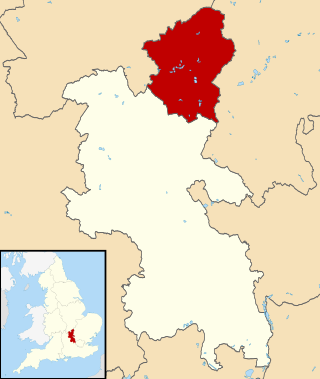
The City of Milton Keynes is a unitary authority area with both borough and city status, in Buckinghamshire. It is the northernmost district of the South East England Region. The borough abuts Bedfordshire, Northamptonshire and the remainder of Buckinghamshire.
Newport Pagnell is a town and civil parish in the City of Milton Keynes, Buckinghamshire, England. The Office for National Statistics records Newport Pagnell as part of the Milton Keynes urban area.

Bletchley is a constituent town of Milton Keynes, Buckinghamshire, England. It is situated in the south-west of Milton Keynes, and is split between the civil parishes of Bletchley and Fenny Stratford and West Bletchley.

Broughton is a historic village, modern district and civil parish in Milton Keynes, Buckinghamshire, England, situated approximately 3 miles (4.8 km) east of Central Milton Keynes. As of 2020, it is governed by Broughton and Milton Keynes Joint Parish Council, which it shares with the neighboring Milton Keynes parish. Today, Broughton is a large district of (greater) Milton Keynes that has been developed around the original village and that grew substantially during the 2000s and 2010s.
Shenley Brook End is a village, district and wider civil parish in Milton Keynes, Buckinghamshire, England, located about 2 miles (3.2 km) north-west of Bletchley, and 2.5 miles (4.0 km) south-west of Central Milton Keynes. Together with its neighbouring districts of Shenley Church End, Shenley Wood and Shenley Lodge, the districts are collectively known as "The Shenleys".

Walton (historically) was a hamlet that is now a district and civil parish in Milton Keynes, Buckinghamshire, England. For local government purposes, it is part of the Danesborough and Walton electoral ward.

Wavendon is a village and civil parish in the south east of the Milton Keynes urban area, in Buckinghamshire, England.
Denbigh is a district in Milton Keynes, Buckinghamshire, England, to the north of Fenny Stratford and on the eastern side of the West Coast Main Line. It is in the civil parish of Bletchley and Fenny Stratford and is categorised by the Office for National Statistics as part of the Bletchley built-up area. The A5 forms its eastern and northern boundary; parts of Bletcham Way and Saxon St form its southern boundary. The overall district has five sub districts, divided by Watling St/Denbigh Rd, the 'uptick' of Bletcham Way and Grafton Street, and Saxon Street northbound. The district names are planning designations that have persisted without ever being changed to the style "North Denbigh" etc. as is the norm elsewhere in Britain.

Bletchleyrailway station serves the southern parts of Milton Keynes, England, and the north-eastern parts of Aylesbury Vale. It is 47 miles (76 km) northwest of Euston, about 32 miles (51 km) east of Oxford and 17 miles (27 km) west of Bedford, and is one of the seven railway stations serving the Milton Keynes urban area.

The A421 is an important road for east/west journeys across south central England. Together with the A428, the A43 and A34, it forms the route from Cambridge through Milton Keynes to Oxford. The section between the A1 and the A5 is a national primary route.

The Milton Keynes redway system is an over 200 miles network of shared use paths for cyclists and pedestrians in Milton Keynes, Buckinghamshire, England. It is generally surfaced with red tarmac, and criss-crosses most of the city.
In January 2004, Deputy Prime Minister John Prescott announced the United Kingdom government's Expansion plans for Milton Keynes. However, the change of government in 2010 and the abolition of the Regional Spatial Strategy in 2012/13 saw these plans revoked and a planned expansion of up to 44,000 dwellings reduced to 28,000. The Milton Keynes Core Strategy was published in July 2013 and regards the figure of 28,000 new homes to be the minimum figure.

This history of Milton Keynes details its development from the earliest human settlements, through the plans for a 'new city' for 250,000 people in northern Southeast England, its subsequent urban design and development, to the present day. Milton Keynes, founded in 1967, is the largest settlement and only city in Buckinghamshire. At the 2021 census, the population of its urban area was estimated to have exceeded 256,000.

The Milton Keynes grid road system is a network of predominantly national speed limit, fully landscaped routes that form the top layer of the street hierarchy for both private and public transport in Milton Keynes, Buckinghamshire. The system is unique in the United Kingdom for its innovative use of street hierarchy principles: the grid roads run in between districts rather than through them. This arrangement permits higher speed limits due to the absence of buildings close to the roads – although more recently some have been limited in part to 40 mph (64 km/h). The grid road system also serves an important purpose of discouraging through-traffic from travelling through neighborhoods and thus reduces traffic noise and pollution in pedestrian areas. Motor traffic is segregated from pedestrian and leisure cycling traffic, which uses the alternative Milton Keynes redway system. Almost all grid junctions are roundabouts, and the absence of traffic lights enables free and efficient movement of traffic.
Kingston is a district in the east side of Milton Keynes, in the civil parish of Kents Hill, Monkston and Brinklow.
Transport in Bedford provides links between the town and other parts of England. Road access to and from the town is provided by the A6 and A421 roads; the former connects the town with Kettering to the north-west, and Luton to the south, whilst the latter connects the town with Milton Keynes and the M1 to the west, and the A1 to the east via a bypass, with both being around 10 miles (16 km) away. Other roads that serve or skirt the town include the A422, which runs westwards into Milton Keynes, and the A428, which runs between Coventry and Cambridge.
The South East Midlands Local Enterprise Partnership (SEMLEP) was established in 2011, and is one of 39 Local Enterprise Partnerships set up by the Government to drive economic development in England. The SEMLEP geographical region includes 36 enterprise and innovation centres, and five universities. Its board is made up of representatives from the public and private sectors, in addition to skills providers.
Glebe Farm is a district of south-east Milton Keynes in Buckinghamshire, England, within the Wavendon civil parish. It was constructed to help the Milton Keynes urban area with its rapid increase in demand for housing. The site is part of the "Eastern Expansion Area" of Milton Keynes, identified in 2004 by the then government. The district is home to the city's first all-through school, Glebe Farm School, with space for 1,500 pupils.

