In The King's England: Northamptonshire, edited by Arthur Mee, it notes:
It was here when The Conqueror gave these lands to his niece the Countess Judith, and except for the clock and the battlements it looks today as it looked then... It is called Earls Barton because it was the Earl of Huntingdon's barley farm; his house stood where the church stands and the remains of its moat can be seen.
Architectural historian Nikolaus Pevsner disagrees with this assessment, describing it as:
...a conspicuous and quite unmistakable Normancastle-motte. It is so close to the church that it stands partly in the church-yard; on this side it appears to have been cut back to make more room. To the N it is protected by a particularly fine ditch.
He goes on to argue that the castle was founded at the time of the Norman Conquest of England in 1066, and its builder ignored the then existing church, leaving it in its bailey for a later demolition that never happened.
In the 13th century, shoes began to be made from leather bought in nearby Northampton, while the village also had its own tanyard, which remained in operation until 1984. During the 14th and 15th centuries, sheep shearing gave way to the manufacture of woollen cloth, which remained a major cottage industry until the shift to the newly industrialised north several centuries later.
Census data shows that from 1801 to 1850, the village population grew from 729 to over 2,000. In 1880, the Barker shoe company was founded in Earls Barton, and remains there to the present day.
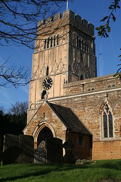
West Street, Earls Barton showing the top of its distinctive Saxon tower.
Between 1913 and 1921, ironstone was produced in two local quarries; the first, situated north of Doddington Road, began operations in 1913, the second in 1916, west of Wellingborough Road. A 3-foot gauge tramway connected both quarries to the northern terminal of the gas-powered aerial ropeway, where the ore was loaded into buckets. It was then taken across the River Nene to Castle Ashby and Earls Barton station, and loaded into railway wagons.
The tramway initially used horses, until a steam locomotive was bought in 1914 to replace them. Quarrying was at first done by hand, using explosives, then steam diggers were used from 1918. In 1925 the original quarry was reopened, not for iron ore, but for the obtaining of gannister (white silica sand). A new 2 foot gauge tramway was used to take the sand to Wellingborough Road where it was loaded into lorries for dispatch. This tramway used a small diesel locomotive. It is not clear how long gannister was quarried but the quarry still appears to have been in use in 1949 and a rusty quarry machine was in situ in the 1970s. The quarried area has mostly been built on but some traces of the system remain including part of a final gullet north of Doddington Road and the remains of a bridge in that road. The remains of the tipping point from the tramway to the ropeway can be seen from Dowthorpe Hill and Milbury.[3]
The Church of England parish church of All Saints has been a feature of the village for many centuries. Its Anglo-Saxon tower dates to ca 970 AD. Pevsner says that the church tower as built was not originally followed by a nave, but a chancel. He also describes the tower's bell openings as being very unusual, having five narrow arches each on turned balusters.
All Saints' underwent two phases of Norman enlargement, one at either end of the 12th century.
The Anglo-Saxon Church at Earls Barton
Other notable features include:
a Norman or Anglo-Saxon door and arcading on the western end of the building – this was the original entrance to the church
Apart from the Saxon tower, the church is mainly built from Northamptonshire ironstone and limestone, while the tower was constructed from Barnack stone and infilled with local limestone.
Another feature is that every century from the 10th century onwards is represented in either the fabric or the fittings of the church building. It is decorated with the work of the local artist Henry Bird.[4]
The church was featured on a 1972 postage stamp issued by the Royal Mail, as part of a set depicting village churches.[5] Another Anglo-Saxon church can be found nearby in Brixworth.
There is a Methodist church on Broad Street; the church building is over 200 years old and is home to many village groups including the 1st Earls Barton Boys' Brigade, badminton club and wives group. There were Baptist and Roman Catholic churches as well; however, both have now been deconsecrated. The Baptist church is now used as a children's nursery and St Anselm's Catholic Church has been converted into offices.[6]
Miscellany
The village was the inspiration for the film Kinky Boots and part of the film was shot here. It is based on the true story of a local boot factory which turned from Dr Marten's, their own Provider brand and traditional boots to producing "fetish" footwear in order to save the ailing family business and the jobs of his workers. The village has a history of ingenious industry including the Barker's shoe factory, a woven label company, and the White & Co factory that produced Tredair and Dr Marten's boots until 2003.
In the village's small market square there is a pharmacy run by a member of the Jeyes chemist's family, which family invented and manufactured Jeyes Fluid. The family also ran the Philadelphus Jeyes chemist chain and lived nearby at Holly Lodge in Boughton.
'Dr Fright's Night' halloween shows are hosted at White's Farm near Earls Barton, popular with neighbouring villages and towns.
In snowy conditions Kensit's field becomes a popular attraction for sledgers due to its steep hill.
After a change in policy regarding public libraries by Northamptonshire County Council, in 2019/2020 the local community took over the running of the village library.
A murder that took place in the village in 2019 was featured on the Sky documentary series Killer in My Village (Season 5, Episode 10).[7]
The village has a cricket team. While the date it was established is unknown, there has been cricket in Earls Barton since the late 19th century. The club has two teams that play in the Northamptonshire Cricket League. It also has Kwik Cricket, U11's, U13's, U15 and U17's teams.
The local football team, Earls Barton FC, was formed in the late 19th century. When Northampton Town FC (The Cobblers) was first formed in 1897, their first game was against Earls Barton United (EBU) on 18 September 1897. The final score Cobblers 4 – EBU 1. Currently Earls Barton United Football Club compete in the Premier Division of the Northants Combination, which is at Step 7 of the English non-league pyramid.
"Earls Barton Motors" was home to Britain's 1957 stock car World Champion, Aubrey Leighton, who was a recognised innovator and builder of stock cars, as well as a racer.[citation needed]
Neighbourhood plan
In 2012 the Parish Council helped coordinate the development of a Neighbourhood Plan following the introduction of the Localism Act. A Project Group worked with local residents to produce a plan, adopted after a referendum in 2015. The plan was submitted to Wellingborough Borough Council[13] and will be integrated into planning considerations for the next twenty years.
Commerce and trade
Since 1880, Earls Barton has been home to Barker Shoes of England. A traditional English peg boot maker, Arthur Barker established a boot making enterprise, sending work to employees who worked in workshops at home. At the turn of the century, Barker invested in factory premises in Station Road, Earls Barton and in 1905 his sons joined the business. During the First and Second World War, Barker Shoes received contracts to make and repair military boots. Today Barker Shoes specialise their production in making Goodyear welted shoes and boots with leather and dainite rubber and still employ many of the local Earls Barton community.
In April 2017, the closure of the last branch of a bank or building society within the village was announced. Market Harborough Building Society (MHBS) wrote to customers announcing the closure of the branch located in Jeyes of Earls Barton, stating the new 'local' branches are in Kettering or Rothwell. MHBS cited lack of footfall and transactions as people undertake more banking online as the main reason for the branch closure.
In 2016 the Post Office in the village, a local sorting office and main Post Office, closed and a small branch counter opened in the Premier store on Station Road. Any collection of mail moved to the Northampton main sorting office from the branch.
Pubs in Earls Barton include the Stag's Head; the Saxon Tavern, opened in an old Lloyds Bank branch,[14] and The Old Swan.[15] In 2020, during the UK health crisis, The Old Swan provided free stew to the community with home delivery funded by off-sales, joint landlord Paul Dexter receiving media attention.[16]
White's Nursery operates a market shop and show grounds, with a planning application to redevelop the retail parts of the site to increase retail space. The show grounds host annual and more frequent events such as Car Shows.
↑Tonks, Eric (April 1989). The Ironstone Quarries of the Midlands Part 3: The Northampton Area. Cheltenham: Runpast Publishing. p.140–149. ISBN1-870-754-034.
↑Times (29 April 2000) Henry Bird, Obituary The Times
This page is based on this Wikipedia article Text is available under the CC BY-SA 4.0 license; additional terms may apply. Images, videos and audio are available under their respective licenses.