Early history of the Arkansas Valley in Colorado

Last updated
The confluence of Grape Creek and the Arkansas River in Colorado. Grape Creek (Colorado).jpg
The confluence of Grape Creek and the Arkansas River in Colorado.

The early history of the Arkansas Valley in Colorado began in the 1600s and to the early 1800s when explorers, hunters, trappers, and traders of European descent came to the region. Prior to that, Colorado was home to prehistoric people, including Paleo-Indians, Ancestral Puebloans, and Late prehistoric Native Americans. [1] [2] [3]

Contents

With westward expansion of the United States, Colorado saw a number of trading posts and small settlements established in the Arkansas and South Platte valleys including Bent's Fort and El Pueblo. Southern Colorado, previously part of New Spain, was ceded in 1848 to the United States following the end of the Mexican–American War (1846–48). The early history of the Arkansas valley ends with the Colorado Gold Rush of 1858 when large numbers of Anglo-Americans began to arrive in Colorado. Colorado achieved statehood in 1876. [1] [2] [lower-alpha 1]

Native Americans

From prehistoric times until the 19th century, bands of the Ute people occupied the upper Arkansas River valley, roughly upstream from present day Pueblo, Colorado. East of Pueblo on the Great Plains and along the Arkansas lived the semi-agricultural Apache peoples of the Dismal River Culture. [4] By the 1730s most of the Apache were driven southward by the Comanche who had begun to dominate the Arkansas River valley in Colorado. The Jicarilla Apache, however, survived by moving from the Arkansas River to the Colorado/New Mexico border area and cultivating friendly relations with the Spanish colonists in New Mexico. During the first half of the 19th century, some factions of the Arapaho and Cheyenne people moved southward into the Arkansas River Valley, becoming allies of the Comanche. Author Hämäläinen postulated a Comanche proto-empire in the early 19th century with an important trading emporium in the Big Timbers, a cottonwood forest bordering the Arkansas from La Junta downstream to near the Kansas border. [5] [6]

New Spain and Mexico

The Spanish settled in New Mexico called the Arkansas River in Colorado the Rio Napestle. In 1644, Juan de Archuleta led the first known Spanish expedition to the Arkansas River valley in Colorado. Archuleta's objective was to find and force Pueblo Indians from Taos who had fled Spanish rule to El Quartelejo, a vaguely defined region from the Arkansas River northward. He found the runaway Pueblos near present day Las Animas. (Some sources state that this expedition took place in 1664.) In 1706, Juan de Ulibarri led another expedition to El Quartelejo, to recapture runaway Pueblos, crossing the Arkansas River in Colorado. [7] [8] [9] In 1779, New Mexico Governor Juan Bautista de Anza led an expedition of more than 600 Spaniards and Indians north into Colorado to punish the Comanche who were raiding the Spanish colonies. De Anza defeated the Comanches south of the Arkansas River near Greenhorn Mountain. [10] in 1787, the Spanish established a settlement called San Carlos de los Jupes at the junction of the Arkansas and the St. Charles River about 8 mi (13 km) east of present day Pueblo. The Jupes were a Comanche sub-tribe and the purpose of the settlement was to encourage the Comanches to become sedentary Christians. San Carlos failed within a year. [11]

The Adams-Onis Treaty of 1819 established the border between the U.S. and Mexico at the Arkansas River in Colorado. Adams onis map.png
The Adams-Onis Treaty of 1819 established the border between the U.S. and Mexico at the Arkansas River in Colorado.

The Louisiana Purchase in 1803 gave the U.S. ownership of a large, but undefined, portion of the Arkansas River Valley. The Adams-Onis Treaty of 1819 established the border between Spanish Mexico and the United States in Colorado. Spanish territory was south of the Arkansas river and U.S. territory was north of the River. The government of New Mexico attempted to counter growing U.S. influence in its territory by giving large land grants to prominent citizens and encouraging settlement of the land grants. The Vigil and St. Vrain grant of 1843 spanned most of eastern Colorado south of the Arkansas. However, in 1848, the U.S. and Mexico signed the Treaty of Guadalupe Hidalgo by which New Mexico and southern Colorado became part of the United States. [12] [13]

1845 Santa Fe Trail and native tribal lands 1845 Santa Fe Trail.jpg
1845 Santa Fe Trail and native tribal lands

The Americans

Kentuckian James Purcell (Pursley) is the first American known to visit the Arkansas River in Colorado. In 1805, he traversed the upper Arkansas with a large band of Paducah (perhaps Plains Apache) and Kiowa Indians. [14] The Zebulon Pike expedition of 1806 followed the Arkansas River upstream to explore for the United States the newly acquired Louisiana territory. Pike and his men strayed into Spanish territory and were arrested and imprisoned. [15] In 1811 Ezekial Williams (not to be confused with Old Bill Williams) trapped in the upper Arkansas valley. [11]

William Becknell opened trade between the United States and newly-independent Mexico in 1821 when he established the Santa Fe Trail. Becknell's pack train followed the Arkansas River from Missouri to near present-day La Junta, Colorado, then turned southwest and followed the Arkansas River tributary, the Purgatoire River, southwest to New Mexico. Wagon trains with trade goods followed this route until 1880. [16] In 1822 Jacob Fowler and a few men of the Glenn-Fowler Expedition spent a month living at the future site of Pueblo becoming the first residents, albeit temporary, of the Arkansas River valley in Colorado. [17] The American interest in the region in the 1820s and 1830s was two-fold: trade with New Mexico via the Santa Fe Trail and trapping for furs, primarily beaver. This was the era of the mountain men, Americans, including men of Anglo, French, American Indian and African-American descent, who roamed the Rocky Mountains to trap beaver whose pelts were used to make fashionable top hats. Taos, New Mexico was the base for many of the mountain men who trapped and explored the Arkansas Valley. [18]

Trappers played an important role in the westward expansion of the United States: "They knew the easiest routes through the high mountains, which rivers could lead a party to safety and which were likely to lead to tragedy. They could tell you what you could expect to find to eat or drink and what weather or wildlife might be encountered. Much of this wealth of knowledge was passed on by word of mouth." [19]

John Gantt

Gantt's Picket Post, also known as Fort Gantt, was built near the present-day Las Animas in 1832 by John Gantt and Jefferson Blackwell. It operated as a trading post until some time in 1834. Fort Cass was then built near the present-day city of Pueblo, Colorado by John Gantt, [20] a former Army officer. It was built in May 1834 on the north side of the Arkansas River, about 6 miles below Fountain Creek. William Bent of St. Vrain & Company attacked Shoshone Indians trading at Gantt's Fort, killing a few and driving them away. Gantt abandoned his fort that winter. The Bents left their stockade and built Bent's Fort about 70 miles down the Arkansas. The adobe forts were built by Mexican laborers hired for construction and other work. Mexican workmen built permanent adobe forts and trading posts as far north and west as Idaho and were a major part of the frontier workforce forming the foundation of the bi-cultural population of Southern Colorado. [21] [lower-alpha 2] The trading post operated until some time in 1835. [20]

Bent, St. Vrain & Company

Bent's Fort in 1848 Bent's Fort 1848.png
Bent's Fort in 1848
Train of covered wagons on the Santa Fe Trail Train of covered wagons on the Santa Fe Trail.jpg
Train of covered wagons on the Santa Fe Trail

Bent, St. Vrain & Company was a partnership formed in New Mexico by Charles Bent and Ceran St. Vrain, traders on the Santa Fe Trail from St. Louis. In 1832 they entered the Indian trade as licensed traders, completing Bent's Fort in 1835 with Charles' younger brother William as manager. William Bent, as well as younger brothers George and Robert later became partners. Marcellin St. Vrain, Ceran's younger brother, who managed Fort St. Vrain for the firm on the South Platte, was never a partner. In addition to Bent's Fort on the Arkansas and Fort St. Vrain on the South Platte the firm maintained a store in Taos managed by Charles Beaubien. The firm's relations with the Cheyenne was cemented by the marriage of William with Owl Woman, daughter of White Thunder, Keeper of the Sacred Arrows of the Cheyenne. A post built on the South Canadian River to trade with the Kiowa and Comanche was only briefly maintained; however, later, two battles were fought at its ruins, by then known as Adobe Walls. [22] [lower-alpha 3]

El Pueblo

The fort was believed to have looked like the Mexican Ranch by Colonel Henry Inman, published in The Old Santa Fe Trail, 1897 Mexican ranch by Colonel Henry Inman 1897.jpg
The fort was believed to have looked like the Mexican Ranch by Colonel Henry Inman, published in The Old Santa Fe Trail, 1897

The fur trade collapsed about 1840 due to over-trapping and changing fashions. Former trappers were forced to seek alternative occupations which led to the establishment of trading and agricultural settlements in the Arkansas River valley of Colorado. El Pueblo, also called Fort Pueblo, was an adobe settlement and trading post built in 1842 by a group of independent traders at the ford of the Arkansas about half a mile west of the Fountain River. [24] The exact location of the site is somewhat uncertain but is near First Street and Santa Fe Avenue in Pueblo, Colorado. The course of the Arkansas has changed by floods and the ford is gone, as is all surface evidence of the buildings at the fort. [25] The builders of Fort Pueblo included George Simpson, son of a wealthy St. Louis merchant, who at 23 had set out in May 1841 on the Oregon Trail with a mule-drawn wagon. Simpson received a yearly remittance from his father throughout his life. Simpson was side-tracked from his westward journey at Fort Laramie when he was invited by William S. Williams to join a company of fur trappers. However, he never went but was hired by Robert Fisher a trader for Bent & St. Vrain and journeyed down the Front Range of the Rockies to Bent's Fort where he learned the basics of trading with the Indians. Fisher was his principle associate in establishing Fort Pueblo. [26]

In 1847, George Ruxton described Pueblo as "a small square fort of adobe with circular bastions at the corners, no part of the walls being more than eight feet high, and round the inside of the yard or corral are built some half-dozen little rooms inhabited by as many Indian traders, coureurs des bois, and mountain men." [27]

See also

Notes

  1. Quote from source: Pueblo, Hardscrabble, and Greenhorn were among the very first white settlements in Colorado
  2. Quote from source: John Gantt was the first to make a business of trading with the Indians on the Arkansas.
  3. Quote from source: By 1842 Bent's Fort reigned supreme in the Arkansas Valley. Competing posts were so short lived that almost no records of them remain.

Related Research Articles

<span class="mw-page-title-main">James Beckwourth</span> Explorer, born into slavery

James Pierson Beckwourth was an American fur trapper, rancher, businessman, explorer, author and scout. Known as "Bloody Arm" because of his skill as a fighter, Beckwourth was of multiracial descent, being born into slavery in Frederick County, Virginia. He was eventually emancipated by his enslaver, who was also his father, and apprenticed to a blacksmith so that he could learn a trade.

<span class="mw-page-title-main">Santa Fe Trail</span> 19th-century route through central North America between Franklin, MO, and Santa Fe, NM

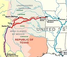
The Santa Fe Trail was a 19th-century route through central North America that connected Franklin, Missouri, with Santa Fe, New Mexico. Pioneered in 1821 by William Becknell, who departed from the Boonslick region along the Missouri River, the trail served as a vital commercial highway until 1880, when the railroad arrived in Santa Fe. Santa Fe was near the end of El Camino Real de Tierra Adentro which carried trade from Mexico City. The trail was later incorporated into parts of the National Old Trails Road and U.S. Route 66.

<span class="mw-page-title-main">Charles Bent</span> American politician (1799–1847)

Charles Bent was an American businessman and politician who served as the first civilian United States governor of the New Mexico Territory, newly invaded and occupied by the United States during the Mexican-American War by the Military Governor, Stephen Watts Kearny, in September 1846.

<span class="mw-page-title-main">Ceran St. Vrain</span> French–American fur trader (1802–1870)

Ceran St. Vrain, born Ceran de Hault de Lassus de Saint-Vrain, was the son of a French aristocrat who emigrated to the Spanish Louisiana in the late 18th century; his mother was from St. Louis, where he was born. To gain the ability to trade, in 1831 he became a naturalized Mexican citizen in what is now the state of New Mexico. He formed a partnership with American traders William, George and Charles Bent; together they established the trading post of Bent's Fort. It was the only privately held fort in the West.

<span class="mw-page-title-main">William Bent</span> American rancher and frontier trader (1809–1869)

William Wells Bent was a frontier trader and rancher in the American West, with forts in Colorado. He also acted as a mediator among the Cheyenne Nation, other Native American tribes and the expanding United States. With his brothers, Bent established a trade business along the Santa Fe Trail. In the early 1830s Bent built an adobe fort, called Bent's Fort, along the Arkansas River in present-day Colorado. Furs, horses and other goods were traded for food and other household goods by travelers along the Santa Fe trail, fur-trappers, and local Mexican and Native American people. Bent negotiated a peace among the many Plains tribes north and south of the Arkansas River, as well as between the Native American and the United States government.

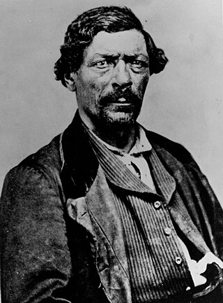
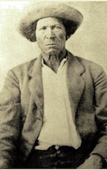
Tom Tobin (1823–1904) was an American adventurer, tracker, trapper, mountain man, guide, US Army scout, and occasional bounty hunter. Tobin explored much of southern Colorado, including the Pueblo area. He associated with men such as Kit Carson, "Uncle Dick" Wootton, Ceran St. Vrain, Charley Bent, John C. Fremont, "Wild Bill" Hickok, William F. Cody, and the Shoup brothers. Tobin was one of only two men to escape alive from the siege of Turley's Mill and Distillery during the Taos Revolt. In later years he was sent by the Army to track down and kill the notorious Felipe Espinosa and his nephew; Tobin returned to Ft. Garland with their heads in a sack.

<span class="mw-page-title-main">Fort Vasquez</span> United States historic place

Fort Vasquez is a former fur trading post 35 miles (56 km) northeast of Denver, Colorado, United States, founded by Louis Vasquez and Andrew Sublette in 1835. Restored by the Works Progress Administration in the 1930s, it now lies in a rather incongruous position as U.S. Route 85 splits to run either side of the building. History Colorado took possession of the property in 1958 and runs it as a museum to display exhibits of the fur-trade era.

Andrew Whitley Sublette or also, spelled Sublett, was a frontiersman, trapper, fur trader, explorer, mountain man and brother to William, Milton, and Solomon, helped establish a trading post with Louis Vasquez in 1835. The present day, Fort Vasquez, located on Highway 85, next to Platteville, Colorado, is a reconstruction. After selling the trading post in 1840, Andrew left the mountains and was seen in El Pueblo around 1844 and 1845, traveling along the Arkansas River, following herds of American Bison.

<span class="mw-page-title-main">Fort Saint Vrain</span> Trading post and fort in Colorado, United States

Fort Saint Vrain was an 1837 fur trading post built by the Bent, St. Vrain Company, and located at the confluence of Saint Vrain Creek and the South Platte River, about 20 miles (32 km) east of the Rocky Mountains in the unorganized territory of the United States, in present-day Weld County, Colorado. A historical marker notes the place where Old Fort St. Vrain once stood, today at the end of Weld County Road 40, located about seven miles north of Fort Vasquez, Colorado. Among those who helped to establish the fort was Ceran St. Vrain, after whom it was named.

<span class="mw-page-title-main">Trapper's Trail</span> Historical trail or road

The Trapper's Trail or Trappers' Trail is a north-south path along the eastern base of the Rocky Mountains that links the Great Platte River Road at Fort Laramie and the Santa Fe Trail at Bent's Old Fort. Along this path there were a number of trading posts, also called trading forts.

Fort Le Duc or Fort LeDuc was a square fort and trading post built near Wetmore, Colorado. It was named after trapper Maurice LeDuc or Maurice LeDoux, and constructed around 1830 or 1835.

<span class="mw-page-title-main">Taos Mountain Trail</span>

The Taos Mountain Trail was the historic pathway for trade and business exchanges between agrarian Taos and the Great Plains (Colorado) from pre-history through the Spanish Colonial period and into the time of the European and American presence. The Taos Mountain Trail, between northern New Mexico and southern Colorado, connected the high mountain traders and their trading partners north and south of the Sangre de Cristo Mountains. Also called the Trapper's Trail, the pathway was only wide enough for people on foot or horses in single file, but it shortened a trip from Taos to the plains farther north from nearly two weeks to three days in good weather. The Taos Mountain Trail was also known as the Sangre de Cristo Trail and the Aztec Trail.

<span class="mw-page-title-main">Teresita Sandoval</span> Co-founder of El Pueblo (1811-1894)

Maria Teresa "Teresita" Sandoval Suazo (1811–1894) was among the first women of European heritage to live in the Arkansas Valley of present-day Colorado. She is one of the founders of El Pueblo in the current city of Pueblo, Colorado. She managed a ranch, the Doyle Settlement, in her later years.

<span class="mw-page-title-main">Charles Autobees</span> Fur trader and American pioneer

Charles Autobees (1812–1882), whose last name was also spelled Urtebise and Ortivis, was a fur trader and pioneer in the American Old West. He was the founder of Autobees, Colorado.

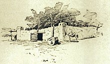
El Pueblo, also called Fort Pueblo, was a trading post and fort near the present-day city of Pueblo in Pueblo County, Colorado. It operated from 1842 until 1854, selling goods, livestock, and produce. It was attacked in 1854, killing up to 19 men and capturing three people. A recreation of the fort is located at the El Pueblo History Museum at the site of the original fort.

Milk Fort, also known as Fort Leche, Pueblo de Leche, Fort El Puebla, Peebles Fort, and Fort Independence was a trading post and settlement in Otero County, Colorado in the late 1830s. There are no remains of the settlement.

Hardscrabble was a settlement established by traders and trappers in the 1840s near the fork of Adobe and Hardscrabble Creeks in present-day Fremont County, Colorado. It was called San Buenaventura de los Tres Arrollos—for three creeks Newlin, Adobe, and Hardscrabble—by its founders, George Simpson, Joseph Doyle, and Alexander Barclay. The name Hardscrabble became more common.

Alexander Barclay was an American frontiersman. After working in St. Louis as a bookkeeper and clerk, he worked at Bent's Old Fort. He then ventured westward where he was a trapper, hunter, and trader. Barclay entered into a common-law relationship with Teresita Sandoval, one of the founders of the settlement and trading post El Pueblo. He helped settle Hardscrabble, Colorado and built Fort Barclay in New Mexico.

John Brown (1817-1889) was a mountain man and trader in the Arkansas River valley in Colorado in the 1840s. From the 1850s until his death he was a prominent businessman and citizen of San Bernardino, California.

References

  1. 1 2 "Colorado". HISTORY. Retrieved 2021-10-23.
  2. 1 2 Lecompte 1978, pp. 1–354.
  3. "BLM Cultural Resource Series: Colorado-Cultural Resources Series No. 2 (Chapter 2)". www.nps.gov. Retrieved 2021-10-24.
  4. "Arkansas River". Colorado Encyclopedia. History Colorado.
  5. DeLay, Brian (2008). War of a Thousand Deserts. New Haven: Yale University Press. pp. 78–81. ISBN   9780300119329.
  6. Hamalainen, Pekka (2008). The Comanche Empire. New Haven: Yale University Press. pp. 33–41, 168, 350–361. ISBN   9780300126549.
  7. "Spanish Exploration in Southeastern Colorado, 1590-1790". Colorado Encyclopedia. Retrieved 26 October 2022.
  8. "Colorado Hispanic/Latino Historical Overview". History Colorado. Retrieved 24 October 2022.
  9. Kenner, Charles L. (1969). A History of New Mexican-Plains Indian Relations. Norman: University of Oklahoma Press. p. 15.
  10. Kenner 1969, pp. 50–51.
  11. 1 2 "Land of Contrasts: A History of Southeastern Colorado, Chapter 3". National Park Service. Retrieved 26 October 2022.
  12. "Mexican Land Grants in Colorado". Colorado Encyclopedia. Retrieved 26 October 2022.
  13. Kessell, John L. (2002). Spain in the Southwest. Norman: University of Oklahoma Press. pp. 368–369. ISBN   0806134070.
  14. Coues, Elliott (1895). The Expeditions of Zebulon Pike. New York: Francis P. Harper. pp. 757–758.
  15. Berry, Trey; Beasley, Pam; Clements, Jeanne, eds. (2006). The Forgotten Expedition, 1804–1805: The Louisiana Purchase Journals of Dunbar and Hunter. Louisiana State University Press. p. xi. ISBN   978-0-8071-3165-7.
  16. "The Encyclopedia of Oklahoma History and Culture". Oklahoma Historical Society. Retrieved 26 October 2022.
  17. "Jacob Fowler Lookout -- Fountain City". The Historical Marker Database. Retrieved 29 October 2022.
  18. Hafen, Leroy. "Colorado's Early Adventurers, the Fur Trappers, 1810-1840". Salt of America. Retrieved 28 October 2022. From the 1933 book by Hafen titled Colorado, the Story of a Western Commonwealth.
  19. Cochran, Sue (April 15, 2019). "A look back at the area's Mountain Men". Canon City Daily Record. Retrieved 2021-10-24.
  20. 1 2 Lecompte 1978, p. PT9.
  21. Lecompte 1978, pp. 10–12.
  22. Lecompte 1978, pp. 14–17.
  23. Lecompte 1978, p. 51.
  24. Lecompte 1978, pp. 35–44.
  25. Lecompte 1978, pp. 83, 265–267.
  26. Lecompte 1978, pp. 3–12, 35.
  27. Ruxton, George F. (1849). Adventures in Mexico and the Rocky Mountains. London: John Murray. p. 220.

Sources

Further reading