Easington, East Riding of Yorkshire

Last updated

Easington
Village and civil parish
High Street, Easington - geograph.org.uk - 983241.jpg
Easington High Street
East Riding of Yorkshire UK location map.svg
Red pog.svg
Easington
Location within the East Riding of Yorkshire
Population691 (2011 census) [1]
OS grid reference TA398192
  London 150 mi (240 km)  S
Civil parish
  • Easington
Unitary authority
Ceremonial county
Region
Country England
Sovereign state United Kingdom
Post town HULL
Postcode district HU12
Dialling code 01964
Police Humberside
Fire Humberside
Ambulance Yorkshire
UK Parliament
List of places
UK
England
Yorkshire
53°39′04″N0°06′50″E / 53.651157°N 0.114000°E / 53.651157; 0.114000

Easington is a small village and civil parish in the East Riding of Yorkshire, England, in the area known as Holderness. A coastal settlement, it is situated between the Humber estuary and the North Sea at the south-eastern corner of the county, and at the end of the B1445 road from Patrington. The coastal town of Withernsea is approximately 6 miles (10 km) to the north-east.

Contents

All Saints' Church, Easington All Saints Church Easington.JPG
All Saints' Church, Easington

The civil parish is formed by the village of Easington and the hamlets of Kilnsea, Out Newton and Spurn Head. Bull Sand Fort is administered as part of the parish. [2] According to the 2011 UK Census, Easington parish had a population of 691, [1] a small decrease on the 2001 UK Census figure of 698. [3]

The parish church of All Saints' is a Grade I listed building. [4]

In 1823 the ecclesiastical parish incumbency was a perpetual curacy under the patronage of the Archbishop of York. The parish had a population of 488, with occupations that included a butcher, a corn miller, a weaver, two blacksmiths, two wheelwrights, two grocers, three shoemakers, four tailors, twelve farmers, two schoolmasters, a land surveyor, a yeoman, and the landlord of the Granby's Head public house. There were two carriers who operated between the village and Hull weekly. [5]

Many years ago, the parish of Easington included Turmarr, Hoton, Northorpe, Dimlington, Old Kilnsea and Ravenser. These villages have been lost to the ever-encroaching sea, and some had disappeared as early as 1400. [6]

The thatched tithe barn is recorded in the National Heritage List for England as a Grade II* listed building, having been designated in 1987. [7]

Easington is significant for being the birthplace of the Anglo-Canadian poet and literary scholar, Robin Skelton (192597). [8]

Gas terminal

Easington terminal Easington Langeled Terminal.jpg
Easington terminal

Easington is the site of a large natural gas terminal, Easington Gas Terminal, consisting of two terminals owned and operated by BP: Centrica Storage which processes and stores gas offshore; and Gassco, operating the Norway to UK Langeled pipeline. In October 2022, Centrica announced that the undersea Rough natural gas storage facility, closed since 2017, was ready for partial re-opening. [9] Since December 2022 the terminal pumps gas to and from the facility, which acts as a reservoir to manage seasonal trends in the supply and demand of gas in the UK. [10]

Related Research Articles

<span class="mw-page-title-main">Flamborough</span> Village and civil parish in the East Riding of Yorkshire, England

Flamborough is a village and civil parish in the East Riding of Yorkshire, England. It is situated approximately 4 miles (6 km) north-east of Bridlington town centre on the prominent coastal feature of Flamborough Head.

Leconfield is a village and civil parish in the East Riding of Yorkshire, England, about 3 miles (5 km) north-west of Beverley town centre on the A164 road. The civil parish consists of Leconfield, the village of Arram and the hamlet of Scorborough. The 2011 UK census gave the parish a population of 2,127, an increase on the 2001 UK census figure of 1,990.

<span class="mw-page-title-main">Mappleton</span> Village and civil parish in the East Riding of Yorkshire, England

Mappleton is a village and civil parish in the East Riding of Yorkshire, England. It is situated on the North Sea coastline in an area known as Holderness, lying approximately 3 miles (5 km) south of the seaside resort of Hornsea. The civil parish is formed by the village of Mappleton and the hamlets of Cowden, Great Cowden and Rolston. According to the 2011 UK census, Mappleton parish had a population of 342, an increase on the 2001 UK census figure of 249.

<span class="mw-page-title-main">Patrington</span> Village and civil parish in the East Riding of Yorkshire, England

Patrington is a large village and civil parish in the East Riding of Yorkshire, England, in an area known as Holderness, 9 miles (14 km) south-east of Hedon, 16 miles (26 km) south-east of Kingston upon Hull and 4 miles (6.4 km) south-west of Withernsea on the A1033. Along with Winestead, it was a seat of the ancient Hildyard/Hilliard/Hildegardis family.

<span class="mw-page-title-main">Wressle</span> Village and civil parish in the East Riding of Yorkshire, England

Wressle is a village and civil parish in the East Riding of Yorkshire, England, lying on the eastern bank of the River Derwent approximately 3 miles (5 km) north-west of Howden.

<span class="mw-page-title-main">Aldbrough, East Riding of Yorkshire</span> Village and civil parish in the East Riding of Yorkshire, England

Aldbrough is a village and civil parish in the East Riding of Yorkshire, England, about 12 miles (19 km) north-east of Hull at the junction of the B1242 and B1238 roads. It lies near to the North Sea coast within the area of Holderness.

<span class="mw-page-title-main">Easington, North Yorkshire</span> Village in North Yorkshire, England

Easington is a village in the civil parish of Loftus, in the Redcar and Cleveland district, in the ceremonial county of North Yorkshire, England and is part of the North York Moors National Park. The village is situated on the A174 road, 1 mile (1.6 km) east of Loftus, 8 miles (13 km) east of Guisborough, and 10 miles (16 km) north-west of Whitby. At the 2011 census, the village had a population of 923.

<span class="mw-page-title-main">Fangfoss</span> Village in the East Riding of Yorkshire, England

Fangfoss is a village and civil parish in the East Riding of Yorkshire, England. It is situated approximately 11 miles (18 km) to the east of the city of York and 3.5 miles (6 km) north-west of the town of Pocklington. The parish includes Bolton. The civil parish is called "Fangfoss" and its parish council is called "Fangfoss with Bolton Parish Council" after Bolton parish was abolished on 1 April 1935 and merged with Fangfoss. The parish covers an area of 900.98 hectares. In 2011 it had a population of 581, a decrease on the 2001 UK census figure of 602.

<span class="mw-page-title-main">Skeffling</span> Village and civil parish in the East Riding of Yorkshire, England

Skeffling is a village and civil parish in the East Riding of Yorkshire, England, in an area known as Holderness. It is situated approximately 5 miles (8 km) south of the town of Withernsea and 4 miles (6.4 km) south-east of the village of Patrington on the B1445 road from Patrington to Easington.

<span class="mw-page-title-main">Rimswell</span> Village and civil parish in the East Riding of Yorkshire, England

Rimswell is a village and civil parish in the East Riding of Yorkshire, England, in an area known as Holderness. It is situated approximately 2 miles (3 km) north-west of Withernsea and it lies between the B1243 and B1362 roads.

<span class="mw-page-title-main">North Dalton</span> Village and civil parish in the East Riding of Yorkshire, England

North Dalton is a village and civil parish in the East Riding of Yorkshire, England. It is situated approximately 6 miles (10 km) south-west of the town of Driffield and 8 miles (13 km) north-east of the town of Pocklington. 4 miles (6.4 km) to the north-west lies the village of Huggate. South Dalton lies some 4.5 miles (7 km) to the south-east, with villages in between. North Dalton itself lies on the B1246 road.

<span class="mw-page-title-main">Lund, East Riding of Yorkshire</span> Village and civil parish in the East Riding of Yorkshire, England

Lund is a village and civil parish in the East Riding of Yorkshire, England. It is situated approximately 6 miles (10 km) north-west of Beverley and 7 miles (11 km) south-west of Driffield.

<span class="mw-page-title-main">Kilnsea</span> Hamlet in the East Riding of Yorkshire, England

Kilnsea is a village in the civil parish of Easington, in the East Riding of Yorkshire, England, in an area known as Holderness. It is situated approximately 2 miles (3 km) south of the village of Easington, on the north bank of the Humber Estuary.

<span class="mw-page-title-main">Rough (facility)</span> Natural gas storage facility under the North Sea

Rough is a natural gas storage facility under the North Sea off the east coast of England. It is capable of storing 100 billion cubic feet of gas, nearly double the storage capacities in operation in Great Britain in 2021.

<span class="mw-page-title-main">Holmpton</span> Village and civil parish in the East Riding of Yorkshire, England

Holmpton is a village and civil parish in the East Riding of Yorkshire, England, in an area known as Holderness. It is situated approximately 3 miles (5 km) south of Withernsea town centre and 3 miles (5 km) east of the village of Patrington. It lies just inland from the North Sea coast.

<span class="mw-page-title-main">Halsham</span> Village and civil parish in the East Riding of Yorkshire, England

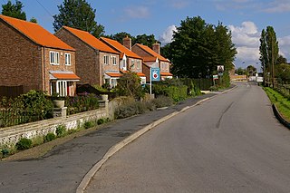
Halsham is a village and civil parish in the East Riding of Yorkshire, England, in an area known as Holderness. It is situated approximately 4 miles (6.4 km) west of Withernsea town centre and it lies south of the B1362 road.

<span class="mw-page-title-main">Ellerton, East Riding of Yorkshire</span> Village in the East Riding of Yorkshire, England

Ellerton is a village and civil parish in the East Riding of Yorkshire, England. It is situated approximately 8 miles (13 km) north-west of the market town of Howden and 8 miles south-west of the market town of Pocklington. It lies west of the B1228 road and east of the River Derwent. According to the 2011 UK census, the parish had a population of 388, an increase on the 2001 UK census figure of 355. and covers an area of 1,824.551 hectares.

<span class="mw-page-title-main">Easington Gas Terminal</span> Gas terminal in Easington, East Riding of Yorkshire

The Easington Gas Terminal is one of six main gas terminals in the UK, and is situated on the North Sea coast at Easington, East Riding of Yorkshire and Dimlington. The other main gas terminals are at St Fergus, Aberdeenshire; Bacton, Norfolk; Teesside; Theddlethorpe, Lincolnshire and Rampside gas terminal, Barrow, Cumbria. The whole site consists of four plants: two run by Perenco, one by Centrica and one by Gassco. The Easington Gas Terminals are protected by Ministry of Defence Police officers and are provided with resources by the Centre for the Protection of National Infrastructure.

<span class="mw-page-title-main">Yorkshire Coast</span> Coastline of Yorkshire, England

The Yorkshire Coast runs from the Tees estuary to the Humber estuary, on the east coast of England. The cliffs at Boulby are the highest on the east coast of England, rising to 660 feet (200 m) above the sea level.

<span class="mw-page-title-main">Church of St Helen, Kilnsea</span> Church in the East Riding of Yorkshire, England

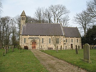
The Church of St Helen, Kilnsea, Holderness, East Riding of Yorkshire, England, is a redundant parish church dating from 1864–5. It was designed by the architect William Burges, and partly paid for by his father Alfred Burges, and is a Grade II listed building.

References

  1. 1 2 UK Census (2011). "Local Area Report – Easington Parish (1170211168)". Nomis. Office for National Statistics . Retrieved 17 February 2018.
  2. John Morris Associates. "Southfield Farm Wind Turbine Landscape and Visual Assessment" (PDF). East Riding of Yorkshire Council. p. 61. Archived from the original (PDF) on 31 January 2015. Retrieved 31 January 2015.
  3. UK Census (2001). "Local Area Report – Easington Parish (1543504214)". Nomis. Office for National Statistics . Retrieved 8 December 2018.
  4. Historic England. "Church of All Saints (1346602)". National Heritage List for England . Retrieved 5 March 2013.
  5. Baines, Edward (1823). History, Directory and Gazetteer of the County of York. pp. 199, 200.
  6. Welton, Michael A. (January 2007). "Easington". Skeals.co.uk. Retrieved 23 March 2010.
  7. Historic England. "Tithe Barn (1083473)". National Heritage List for England . Retrieved 15 August 2013.
  8. Crowther, Pete (14 June 2007). "Robin Skelton of Easington, Poet, Literary Scholar and Witch". The Spurn, Kilnsea and Easington Area Local Studies Group. Archived from the original on 31 December 2010. Retrieved 2 June 2008.
  9. "UK's biggest gas storage site reopened to boost winter energy supplies". The Guardian. 28 October 2022. Retrieved 28 October 2022.
  10. Lawson, Alex (1 December 2022). "Back online: the retired gas storage site now able to power 1m homes". The Guardian. Retrieved 1 December 2022.