East Brady, Pennsylvania

Last updated
East Brady, Pennsylvania
East Brady, Pennsylvania (8480954903).jpg
A street in East Brady
Clarion County Pennsylvania Incorporated and Unincorporated areas East Brady Highlighted.svg
Location of East Brady in Clarion County, Pennsylvania.
Map of Pennsylvania highlighting Clarion County.svg
Map showing Clarion County in Pennsylvania
USA Pennsylvania location map.svg
Red pog.svg
East
Brady
Location in Pennsylvania
Coordinates: 40°59′04″N79°36′55″W / 40.98444°N 79.61528°W / 40.98444; -79.61528
Country United States
State Pennsylvania
County Clarion
Settled1854
Platted 1866
Incorporated1869
Government
  TypeBorough Council
  MayorWilliam Rode
Area
[1]
  Total1.11 sq mi (2.87 km2)
  Land0.81 sq mi (2.10 km2)
  Water0.30 sq mi (0.77 km2)
Elevation
960 ft (290 m)
Population
 (2020) [2]
  Total818
  Density1,011.12/sq mi (390.37/km2)
Time zone UTC-5 (Eastern (EST))
  Summer (DST) UTC-4 (EDT)
ZIP code
16028
FIPS code 42-20840

East Brady is a borough in Clarion County, Pennsylvania, United States. The population was 822 at the 2020 census. [3] Clarion County's designated tourism agency is Discover Clarion County

Contents

History

East Brady is named after Captain Samuel Brady, who battled Native Americans at that location. [4]

Geography

East Brady is located in the southwestern corner of Clarion County at 40°59′4″N79°36′55″W / 40.98444°N 79.61528°W / 40.98444; -79.61528 (40.984550, -79.615333), [5] on the east side of a bend in the Allegheny River, at a point 69 miles (111 km) upstream from the river's mouth in Pittsburgh. Pennsylvania Route 68 passes through the borough, crossing the Allegheny on the Sergeant Carl F. Curran II Bridge to Armstrong County and the community of Bradys Bend. PA 68 leads southwest 21 miles (34 km) to Butler and northeast 24 miles (39 km) to Clarion.

According to the United States Census Bureau, East Brady has a total area of 1.1 square miles (2.9 km2), of which 0.81 square miles (2.1 km2) is land and 0.31 square miles (0.8 km2), or 27.00%, is water. [6]

Demographics

Historical population
CensusPop.Note
1870 728
1880 1,24270.6%
1890 1,228−1.1%
1900 1,2330.4%
1910 1,49321.1%
1920 1,5312.5%
1930 1,5632.1%
1940 1,427−8.7%
1950 1,400−1.9%
1960 1,282−8.4%
1970 1,218−5.0%
1980 1,153−5.3%
1990 1,047−9.2%
2000 1,038−0.9%
2010 942−9.2%
2020 822−12.7%
2021 (est.)820 [3] −0.2%
Sources: [7] [8] [9] [2]

As of the census [8] of 2000, there were 1,038 people, 471 households, and 287 families residing in the borough. The population density was 1,233.6 inhabitants per square mile (476.3/km2). There were 542 housing units at an average density of 644.1 per square mile (248.7/km2). The racial makeup of the borough was 99.42% White, 0.10% Asian, and 0.48% from two or more races. Hispanic or Latino of any race were 0.29% of the population.

There were 471 households, out of which 24.0% had children under the age of 18 living with them, 48.6% were married couples living together, 8.5% had a female householder with no husband present, and 38.9% were non-families. 36.9% of all households were made up of individuals, and 24.6% had someone living alone who was 65 years of age or older. The average household size was 2.18 and the average family size was 2.81.

In the borough the population was spread out, with 19.3% under the age of 18, 7.1% from 18 to 24, 23.2% from 25 to 44, 23.5% from 45 to 64, and 26.9% who were 65 years of age or older. The median age was 45 years. For every 100 females there were 92.6 males. For every 100 females age 18 and over, there were 87.9 males.

The median income for a household in the borough was $26,667, and the median income for a family was $37,589. Males had a median income of $35,417 versus $21,538 for females. The per capita income for the borough was $15,299. About 10.9% of families and 11.8% of the population were below the poverty line, including 8.2% of those under age 18 and 17.7% of those age 65 or over.

Education

East Brady is part of the Karns City Area School District, with K-6 students attending Sugarcreek Elementary School.

Notable person

See also

Related Research Articles

<span class="mw-page-title-main">East McKeesport, Pennsylvania</span> Borough in Pennsylvania, United States

East McKeesport is a borough in Allegheny County, Pennsylvania, United States, and is part of the Pittsburgh Metro Area. The population was 2,076 at the 2020 census.

<span class="mw-page-title-main">Hovey Township, Armstrong County, Pennsylvania</span> Township in Pennsylvania, United States

Hovey Township is a township which is located in far northern Armstrong County, Pennsylvania, United States. The population was seventy-four at the time of the 2020 census, a decrease from the figure of 97 tabulated in 2010.

<span class="mw-page-title-main">Ashland Township, Pennsylvania</span> Township in Pennsylvania, United States

Ashland Township is a township in Clarion County, Pennsylvania, United States. The population was 1,117 at the 2020 census, an increase from the figure of 1,114 tabulated in 2010.

<span class="mw-page-title-main">Brady Township, Clarion County, Pennsylvania</span> Township in Pennsylvania, United States

Brady Township is a township in Clarion County, Pennsylvania, United States. The population was 75 at the 2020 census, an increase from the figure of 55 tabulated in 2010.

<span class="mw-page-title-main">Callensburg, Pennsylvania</span> Borough in Pennsylvania, United States

Callensburg is a borough in Clarion County, Pennsylvania, United States. The population was 207 at the 2010 census.

<span class="mw-page-title-main">Clarion Township, Clarion County, Pennsylvania</span> Township in Pennsylvania, United States

Clarion Township is a township in Clarion County, Pennsylvania, United States. The population was 3,649 at the 2020 census, a decrease from the figure of 4,116 tabulated in 2010, which was, in turn, an increase over the total of 3,273 at the 2000 census.

<span class="mw-page-title-main">Foxburg, Pennsylvania</span> Borough in Pennsylvania, United States

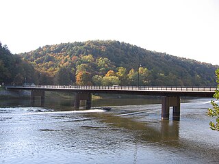
Foxburg is a borough in Clarion County, Pennsylvania, United States. It is located along the east bank of the Allegheny River, about 2 miles (3 km) north of the mouth of the Clarion River. As of the 2020 census it had a population of 181. The designated tourism agency for Clarion County is Discover Clarion County

<span class="mw-page-title-main">Knox, Pennsylvania</span> Borough in Pennsylvania, United States

Knox is a borough in Clarion County, Pennsylvania, United States. The population was 1,102 at the 2020 census. The designated tourism agency for Clarion County in Discover Clarion County

<span class="mw-page-title-main">Madison Township, Clarion County, Pennsylvania</span> Township in Pennsylvania, United States

Madison Township is a township in Clarion County, Pennsylvania, United States. The population was 1,163 at the 2020 census, a decrease from 1,207 in 2010, which represented, in turn, a decline from 1,442 in 2000.

<span class="mw-page-title-main">New Bethlehem, Pennsylvania</span> Borough in Pennsylvania, United States

New Bethlehem is a borough in Clarion County, Pennsylvania, United States. The population was 979 at the 2020 census. The borough is situated at the southwestern corner of the Pennsylvania Wilds Conservation Landscape. Its main street, PA Route 28-66, is a major thoroughfare between the Pittsburgh metropolitan region and northcentral Pennsylvania. The designated tourism agency for Clarion County is Discover Clarion County

<span class="mw-page-title-main">Redbank Township, Clarion County, Pennsylvania</span> Township in Pennsylvania, United States

Redbank Township is a township in Clarion County, Pennsylvania, United States. The population was 1,334 at the 2020 census, a decrease from the figure of 1,370 tabulated in 2010.

<span class="mw-page-title-main">Richland Township, Clarion County, Pennsylvania</span> Township in Pennsylvania, United States

Richland Township is a township in Clarion County, Pennsylvania, United States. The population was 473 at the 2020 census, a decrease from the figure of 494 tabulated in 2010.

<span class="mw-page-title-main">Rimersburg, Pennsylvania</span> Borough in Pennsylvania, United States

Rimersburg is a borough in Clarion County in the U.S. state of Pennsylvania. The population was 945 at the 2020 census.

<span class="mw-page-title-main">Sligo, Pennsylvania</span> Borough in Pennsylvania, United States

Sligo is a borough in Clarion County, Pennsylvania, United States. The population was 686 at the 2020 census.

<span class="mw-page-title-main">St. Petersburg, Pennsylvania</span> Borough in Pennsylvania, United States

St. Petersburg is a borough in Clarion County, Pennsylvania, United States. The population was 338 at the 2020 census.

<span class="mw-page-title-main">Strattanville, Pennsylvania</span> Borough in Pennsylvania, United States

Strattanville is a borough in Clarion County, Pennsylvania, United States. The population was 537 at the 2020 census.

<span class="mw-page-title-main">Toby Township, Pennsylvania</span> Township in Pennsylvania, United States

Toby Township is a township in Clarion County, Pennsylvania, United States. The population was 984 at the 2020 census, a decrease from the figure of 991 in 2010 census, which was, in turn, a decline from 1,166 at the 2000 census.

<span class="mw-page-title-main">Corsica, Pennsylvania</span> Borough in Pennsylvania, United States

Corsica is a borough in Jefferson County, Pennsylvania, United States. The population was 357 at the 2010 census. It was named for the island of Corsica, birthplace of Napoleon Bonaparte. The mayor of the borough is Dave Leadbetter.

<span class="mw-page-title-main">Trafford, Pennsylvania</span> Borough in Pennsylvania, United States

Trafford is a borough in Allegheny and Westmoreland counties in the U.S. state of Pennsylvania. Located near Pittsburgh in western Pennsylvania, the borough lies primarily in Westmoreland County; only a small portion extends into Allegheny County. It was incorporated in 1904 from the northernmost corner of North Huntingdon Township, and was named by George Westinghouse for Trafford near Manchester, England. Westinghouse purchased the land in 1902, and the Trafford Foundry began operations on October 3, 1903. The population was 3,317 at the 2020 census. Of this, 3,113 were in Westmoreland County, and only 61 were in Allegheny County.

<span class="mw-page-title-main">Emlenton, Pennsylvania</span> Borough in Pennsylvania, United States

Emlenton is a borough in Clarion and Venango counties in the U.S. state of Pennsylvania. The population was 625 at the 2010 census. Of these, 617 were in Venango County, and eight were in Clarion County. The borough is home to the Emlenton Bridge on I-80, which spans the Allegheny River.

References

  1. "ArcGIS REST Services Directory". United States Census Bureau. Retrieved October 12, 2022.
  2. 1 2 "Census Population API". United States Census Bureau. Retrieved Oct 12, 2022.
  3. 1 2 Bureau, US Census. "City and Town Population Totals: 2020-2021". Census.gov. US Census Bureau. Retrieved 17 July 2022.
  4. Egle, William H. An Illustrated History of the Commonwealth of Pennsylvania, Harrisburg: De Witt C. Goodrich & Co., 1876, p. 337
  5. "US Gazetteer files: 2010, 2000, and 1990". United States Census Bureau. 2011-02-12. Retrieved 2011-04-23.
  6. "Geographic Identifiers: 2010 Census Summary File 1 (G001): East Brady borough, Pennsylvania". U.S. Census Bureau, American Factfinder. Archived from the original on April 23, 2015. Retrieved April 23, 2015.
  7. "Census of Population and Housing". U.S. Census Bureau. Retrieved 11 December 2013.
  8. 1 2 "U.S. Census website". United States Census Bureau . Retrieved 2008-01-31.
  9. "Incorporated Places and Minor Civil Divisions Datasets: Subcounty Resident Population Estimates: April 1, 2010 to July 1, 2012". Population Estimates. U.S. Census Bureau. Archived from the original on 11 June 2013. Retrieved 11 December 2013.