East Caprivi

Last updated

East Caprivi
Oos-Caprivi
Ostcaprivi
1972–1989
Flag of Caprivi Bantustan.svg
Flag
Coat of arms of East Caprivi.jpg
Coat of arms
Plan Odendaal.png
Allocation of Land to bantustans according to the Odendaal Plan. East Caprivi is in the top right corner.
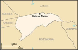
Map BantoustanEastCaprivi.PNG
Map of the bantustan
Status Bantustan (1972-1980)
Second-tier authority (1980-1989)
Capital Katima Mulilo
Common languages Subiya
English
Afrikaans
History 
 Self-government
1972
 Re-integrated into Namibia
May 1989
CurrencySouth African rand
Preceded by
Succeeded by
Flag of South Africa 1928-1994.svg South West Africa
Namibia  Flag of Namibia.svg

East Caprivi or Itenge was a bantustan and later a non-geographic ethnic-based second-tier authority, the Representative Authority of the Caprivis in South West Africa (present-day Namibia), intended by the apartheid government to be a self-governing homeland for the Masubiya people.

Contents

Administrative History

Bantustan (1972-1980)

It was set up in 1972, in the very corner of the Namibian panhandle called the Caprivi Strip. [1] It was granted a self-governing status in 1976.

Unlike the other homelands in South West Africa, East Caprivi was administered through the Department of Bantu Administration and Development in Pretoria. [2]

Representative authority (1980-1999)

Following the Turnhalle Constitutional Conference the system of Bantustans was replaced in 1980 by Representative Authorities which functioned on the basis of ethnicity only and were no longer based on geographically defined areas.

Representative Authorities had executive and legislative competencies, being made up of elected Legislative Assemblies which would appoint Executive Committees led by chairmen.

As second-tier authorities, forming an intermediate tier between central and local government, the representative authorities had responsibility for land tenure, agriculture, education up to primary level, teachers' training, health services, and social welfare and pensions and their Legislative Assemblies had the ability to pass legislation known as Ordinances. [3]

Transition to independence (1989-1990)

East Caprivi, like other homelands in South West Africa, was abolished in May 1989 at the start of the transition to independence.

Leadership

See also

Related Research Articles

<span class="mw-page-title-main">Politics of Namibia</span> Political system of Namibia

Politics of Namibia takes place in a framework of a semi-presidential representative democratic republic, whereby the President of Namibia is both head of state and head of government, and of a pluriform multi-party system. Executive power is exercised by both the president and the government. Legislative power is vested in the two chambers of Parliament. The judiciary is independent of the executive and the legislature.

<span class="mw-page-title-main">South West Africa</span> Mandate of South Africa from 1915 to 1990

South West Africa was a territory under South African administration from 1915 to 1990, after which it became modern-day Namibia. It bordered Angola, Botswana, South Africa, and Zambia.

The history of Namibia has passed through several distinct stages from being colonised in the late nineteenth century to Namibia's independence on 21 March 1990.

<span class="mw-page-title-main">Bantustan</span> Territory created by the Apartheid regime of South Africa

A Bantustan was a territory that the National Party administration of South Africa set aside for black inhabitants of South Africa and South West Africa, as part of its policy of apartheid. By extension, outside South Africa the term refers to regions that lack any real legitimacy, consisting often of several unconnected enclaves, or which have emerged from national or international gerrymandering.

<span class="mw-page-title-main">Caprivi Strip</span> Geographical area of northeastern Namibia

The Caprivi Strip, also known simply as Caprivi, is a geographic salient protruding from the northeastern corner of Namibia. It is bordered by Botswana to the south and Angola and Zambia to the north. Namibia, Botswana and Zambia meet at a single point at the eastern tip of the Strip, which also comes within 150 m (490 ft) of Zimbabwe thus nearly forming a quadripoint. Botswana and Zambia share a 150-metre (490 ft) border at the crossing of Kazungula. The territory was acquired by then-German South West Africa in order to provide access to the Zambezi River and consequently a route to the east coast of the continent and German East Africa. The route was later found not to be navigable because of the location of the Victoria Falls, one of the world's largest waterfalls, about 65 kilometres east of the Caprivi Strip.

<span class="mw-page-title-main">Kaokoland</span>

Kaokoland was an administrative unit and a bantustan in northern South West Africa. Established in 1980 during the apartheid era, it was intended to be a self-governing homeland of the Ovahimba, but an actual government was never established, and the territory was administered by the leaders of Hereroland. Like other homelands in South West Africa, the Kaokoland bantustan was abolished in May 1989, at the beginning of the transition of Namibia towards independence.

<span class="mw-page-title-main">KaNgwane</span>

KaNgwane was a bantustan in South Africa, intended by the apartheid government to be a semi-independent homeland for the Swazi people. It was called the "Swazi Territorial Authority" from 1976 to 1977. In September 1977 it was renamed KaNgwane and received a legislative assembly. After a temporary suspension of its homeland status during 1982, the legislative assembly was restored in December 1982. KaNgwane was granted nominal self-rule in August 1984. Its capital was at Louieville. It was the least populous of the ten homelands, with an estimated 183,000 inhabitants. Unlike the other homelands in South Africa, KaNgwane did not adopt a distinctive flag of its own but flew the national flag of South Africa.

<span class="mw-page-title-main">Bushmanland (South West Africa)</span>

Bushmanland was a bantustan in South West Africa, intended by the apartheid government to be a self-governing homeland for the San people.

<span class="mw-page-title-main">Hereroland</span> Former bantustan in South-West Africa (now Namibia)

Hereroland was a bantustan and later a non-geographic ethnic-based second-tier authority, the Representative Authority of the Hereros, in South West Africa, intended by the apartheid-era government to be a self-governing homeland for the Herero people.

During part of the South African apartheid administration in South West Africa, when Hereroland was a bantustan, a political representative was appointed by the South African Administration. At first, this position was given to the respective Paramount Chief of the Herero people until in 1980, political representation was decoupled from chieftaincy. The position of the representative of Hereroland was abolished in May 1989 as part of the transition to Namibian independence which was declared in March 1990.

<span class="mw-page-title-main">Ovamboland</span> Former Bantustan in South West Africa (now Namibia)

Ovamboland, also referred to as Owamboland, was a Bantustan and later a non-geographic ethnic-based second-tier authority, the Representative Authority of the Ovambos, in South West Africa.

<span class="mw-page-title-main">Damaraland</span> Former bantustan in South West Africa

Damaraland was a name given to the north-central part of South West Africa, which later became Namibia, inhabited by the Damaras. It was bordered roughly by Ovamboland in the north, the Namib Desert in the west, the Kalahari Desert in the east, and the Windhoek region in the south.

<span class="mw-page-title-main">Tswanaland</span>

Tswanaland was a bantustan and then later a non-geographic ethnic-based second-tier authority, the Representative Authority of the Tswanas, in South West Africa, in the far central eastern area of the territory around the village of Aminuis. It was intended by the apartheid government to be a self-governing homeland for the Tswana people.

<span class="mw-page-title-main">Kavangoland</span> Former bantustan in South-West Africa (now Namibia)

Kavangoland was a bantustan and then later a non-geographic ethnic-based second-tier authority, the Representative Authority of the Kavangos, in South West Africa, intended by the apartheid government to be a self-governing homeland for the Kavango people.

<span class="mw-page-title-main">Rehoboth (homeland)</span>

Rehoboth was a homeland in South West Africa intended by the apartheid-era government to be a self-governing homeland for the Baster people in the area around the town of Rehoboth.

<span class="mw-page-title-main">Namaland</span> Former bantustan in South-West Africa (now Namibia)

Namaland was a Bantustan and then later a non-geographic ethnic-based second-tier authority, the Representative Authority of the Namas, the in South West Africa, intended by the apartheid government to be a self-governing homeland for the Nama people. Namaland comprised an area of 2,156 km2 (832 sq mi) and was to accommodate the estimated 34,806 southern Namas of the South West African territory.

East Caprivi was a Bantustan or "homeland" and later a second-tier authority in South West Africa during the apartheid period.

The system of racial segregation and oppression in South Africa known as apartheid was implemented and enforced by many acts and other laws. This legislation served to institutionalize racial discrimination and the dominance by white people over people of other races. While the bulk of this legislation was enacted after the election of the National Party government in 1948, it was preceded by discriminatory legislation enacted under earlier British and Afrikaner governments. Apartheid is distinguished from segregation in other countries by the systematic way in which it was formalized in law.

<span class="mw-page-title-main">Turnhalle Constitutional Conference</span> 1975–1977 conference in Windhoek on self-governance of occupied Namibia

The Turnhalle Constitutional Conference was a conference held in Windhoek between 1975 and 1977, tasked with the development of a constitution for a self-governed South West Africa (Namibia) under South African control. Sponsored by the South African government, the Turnhalle Conference laid the framework for the government of South West Africa from 1977 to independence in 1989.

<span class="mw-page-title-main">Constance Kgosiemang</span>

Constance Letang Kgosiemang was the paramount chief of the Tswana people in Namibia, a parliamentarian, and the leader of the Seoposengwe Party until its merger into the Democratic Turnhalle Alliance (DTA).

References

  1. "A survey of race relations in South Africa: 1974" (PDF). Archived from the original (PDF) on 5 January 2023. Retrieved 21 April 2022.
  2. Lenggenhager, Luregn (4 May 2015). "Nature, War and Development: South Africa's Caprivi Strip, 1960–1980". Journal of Southern African Studies. 41 (3): 467–483. doi:10.1080/03057070.2015.1025337. ISSN   0305-7070. S2CID   142811673.
  3. https://www.lac.org.na/laws/1982/whi23.pdf

17°46′10″S24°12′49″E / 17.76944°S 24.21361°E / -17.76944; 24.21361