East Dundry

Last updated

East Dundry
EastDundry1.jpg
East Dundry in about 2010
Somerset UK location map.svg
Red pog.svg
East Dundry
Location within Somerset
OS grid reference ST575662
Unitary authority
Ceremonial county
Region
Country England
Sovereign state United Kingdom
Post town BRISTOL
Postcode district BS41
Dialling code 0117
Police Avon and Somerset
Fire Avon
Ambulance South Western
UK Parliament
List of places
UK
England
Somerset
51°23′35″N2°36′43″W / 51.393°N 2.612°W / 51.393; -2.612
East Dundry fire-watching instructions and rota for three months in 1942 (World War II) Fire watching 1942 World War II East Dundry, Bristol.jpg
East Dundry fire-watching instructions and rota for three months in 1942 (World War II)
An East Dundry taped window for enemy-bomb protection, December 1940 An East Dundry taped window for bomb protection, December 1940.jpg
An East Dundry taped window for enemy-bomb protection, December 1940
A pump and sink fed from a well in the kitchen of an East Dundry property, 1959 Well water hand pump and kitchen sink. .jpg
A pump and sink fed from a well in the kitchen of an East Dundry property, 1959
The end of overhead open-wire phone lines to East Dundry: East Dundry Lane, looking west, winter 1963 EastDundryLane1963.jpg
The end of overhead open-wire phone lines to East Dundry: East Dundry Lane, looking west, winter 1963
1842 tithe map with names for fields and two farms. Note the tithe-officer signature and stamp near the top. Spring Farm and Walnut Farm are identified. FARM is marked: this is the farm that moved to higher flat land as North Hill Farm after this 1842 map was drawn. East Dundry, Bristol 1842 tithe map.jpg
1842 tithe map with names for fields and two farms. Note the tithe-officer signature and stamp near the top. Spring Farm and Walnut Farm are identified. FARM is marked: this is the farm that moved to higher flat land as North Hill Farm after this 1842 map was drawn.
1955 tithe redemption notice for The Dingle, East Dundry. Note the PS3/3/5 (PS3, 3shillings, and 5pence) "redemption charge" never to again pay the annual 2/11d (2pence + 2pence + 5pence + 2shillings and 2pence = 2shillings and 11pence). Tithe redemption notice.jpg
1955 tithe redemption notice for The Dingle, East Dundry. Note the £3/3/5 (£3, 3shillings, and 5pence) "redemption charge" never to again pay the annual 2/11d (2pence + 2pence + 5pence + 2shillings and 2pence = 2shillings and 11pence).
Registered letter cover Tithe redemption letter.jpg
Registered letter cover
Tithe map for the property Tithe redemption map.jpg
Tithe map for the property

East Dundry is a south-facing hamlet some 160 metres above sea level in a sheltered valley of Dundry Hill just south of Bristol, England. The hamlet is in the parish of Dundry and about two kilometres east of its village church. The iron-age Maes Knoll tump (2.5 kilometres to the east) and tumuli (in the field just north-east of North Hill Farm) are evidence of long occupation of the valley.

Contents

Wansdyke, strip lynchets

East Dundry's northern slope facing Bristol has supposedly a continuation westwards from Maes Knoll of the remains of Wansdyke, a series some 31 km-long of early medieval defensive linear earthworks consisting of a ditch and a running embankment from the ditch spoil, with the ditching facing north, to repel invasion from the north.

There are ancient downhill strip lynchets in the large field opposite North Hill Cottage; and mildly sloping ones in the top field opposite The Rookery.

The original settlements probably owed their existence to the quarrying of the local Dundry stone, which is found at Cardiff Castle and was used in mediaeval Bristol. Nearby Dundry originally had a Roman fort built as part of the local defences against Anglo-Saxon invasions.

The hamlet today has some 16 houses including one active farm (mostly successful breeding turkeys): there were five active farms until the 1950s, two until the 2020s, all mostly supplying milk to Bristol. Most buildings are built from the oolitic limestone quarried locally, probably mostly by the sites of the houses. Two large outcrops of Dundry stone are visible at Spring Farm. Until 1930, the inhabitants were almost entirely farmers and farm workers: gradually since then the hamlet has become a dormitory village for Bristol.

Access, bus service, postal service

East Dundry Lane in the 1920s was the first to be tarred into the hamlet. Bristol, with its centre only 6 kilometres away, had mains water, electricity, gas, and dial telephones by the 1930s – but the Second World War and its ten years of ensuing austerity stopped all extension of these facilities to places such as East Dundry.

From 1923 until the 1950s there was a frequent Dundry Pioneer bus service from its Dundry terminus on the flat part of the Bristol-Wells road near the chapel at the top of Broad Oak Hill, into the then open-air bus terminus in Prince Street in Bristol via Dundry village, the Hairpin Bend, Bishopsworth, and Bedminster.

Until the 1960s, letters were delivered on bicycles to East Dundry and all Dundry premises. The Dundry Post Office was a few houses south of the Carpenter's Arms pub and its north-side neighbour the smithy, all strategically in Cold Harbour on the Bristol-Wells stage-coach mail road. Later the post office was some 200 metres north west of Dundry church in a house on the north side of the road.

Second World War

A week or so before war was declared, several London children were evacuated to East Dundry: for instance two were billeted to Spring Farm, two to The Dingle (now called Dingle House) and some to The Rookery.

Later in the war, refugees from the bombing of Bristol stayed for instance in Spring Farm. Two land girls helped in Walnut Farm and two in Spring Farm. [1]

Bombs and shrapnel fell in East Dundry: bombs fell in the bull pen of the then North Hill Farm on 3 January 1941. [2] Incendiary bombs fell in the hamlet, for instance in the farmyard of Spring Farm. [3] Two East Dundry men were responsible in a rota every night as fire watchers for the hamlet. [4]

Electricity

Negotiations with the Electricity Board started with a meeting in Walnut Farm in 1952, with the installation in 1953 of an 11KV supply from across the valley.

Water supply

Wells

The houses and farms built before about 1890 (and dating back to mediaeval and earlier times) are all geologically close to the division between clay and the higher layer of Dundry hill's oolitic limestone [5] – this allowed wells to be sunk for them, with a reliable supply. Nearly all old East Dundry have wells.

Hydraulic rams

The farmhouses North Hill Farm and Walnut Farm were built in the late 19th century on the hamlet's higher and flatter land – more suitable than the steeper land of the original farms, such as Spring Farm and the farm [6] that was at the current North Hill Cottage with its large flattish walled-garden that was its farm yard. These two higher farms installed separate hydraulic rams in the late 1800s and were served by them until the late 1950s. The farms needed ample water for their dairy herds prosperously supplying milk to Bristol by horse and cart.></ref>Ch [7]

North Hill Farm laid a 6-inch diameter, china-clay pipe (still visible in places in the steep nearby stream) from the spring below Upton Farm to a ram in a small stone hut on the south side of the valley-bottom stream. There remains a narrower metal pipe (crossing the stream and then all under the soil) up and through Nuthill field to North Hill Farm – much higher than the Upton Farm spring. The ram near the stream below Walnut Farm pumped water up to the farm. Upton farm also had (has?) a hidden, disused hydraulic ram near the same spring.

Day and night, the rams thumped every 20 seconds or so ></ref>Ch [8] and were audible throughout East Dundry until the 1950s. [9] Walnut Farm ran their ram well into the mid sixties with the ram feed water supply coming from an open-topped limestone cistern built into the south side of the valley containing approximately 12 cubic metres of water bubbling up from an underground spring. The ram was housed in a small shed 40 metres into the base of the valley next to the stream with the waste wash from the ram flowing into it. The delivery pipe from the ram ran north up to a holding tank at the farm. Once a mains water supply was installed (1957/8) the water from the ram was used solely for livestock and washing down the yards. The rhythmic thumping of the ram had a shorter frequency than the one mentioned at North Hill Farm with gentle knocks about every 3 to 4 seconds.

Mains water

Water (pumped up Dundry hill from the small pumping station half-way up Broad Oak Hill road) was only supplied to the hamlet in 1957/8 after negotiations since 1952. Dundry village had mains water supplied years earlier than East Dundry.></ref>Ch [10]

Gas supply

Gas was first supplied in the 1960s when a gas main to Chew Magna was routed through East Dundry passing up from Bristol along the track north of North Hill Farm, down the hamlet's lane to Cross Cottage, down in the field at the west end of Cross Cottage's garden, along the road past Spring Farm and up the track towards Rattledown Farm. In a few years every joint of this relatively high-pressure-gas steel pipeline had to be resealed when the supply was converted from town to natural gas all the way from the North Sea. Later the pipeline was reduced in pressure to minimise gas losses and only served East Dundry.></ref>Ch [11]

Telephones and data fibre

East Dundry telephone subscribers were originally served by a network of poles and overhead open-wire cables all the way some 6 kilometres from the Chew Magna manual telephone exchange. Due to the Second World War and the following austerity, two houses often shared one of the few available lines with party lines (for example The Dingle had the number Chew Magna 81 from 1931 and the neighbouring North Hill Cottage later shared the line with the number ></ref>Ch [12] Chew Magna 1081). In the late 1950s Bristol's automatic Strowger Bedminster exchange 66xxxx numbers served the hamlet, changing later></ref>Ch [13] to 63xxxx and yet later 963xxxx. Subscriber Trunk Dialling became available on 5 December 1958 to call a few UK cities. Bristol had the dialling code 0BR2 progressively changing to 0272 (the same on the dial as 0BR2), and then 0117 plus 7-digit Bristol numbers.

During the lead-up to Christmas 1962 there were light falls of snow></ref>W Duncan Ogilvie (myself) was a child there</ref>. Around Christmas Eve, after a slight thaw, freezing started again with significant snowfalls during Boxing Day, later to be known as ‘The Big Freeze of 1963’. The previously partially-melted light and fluffy snow formed dense solid ice on the thin copper telephone lines increasing their weight. This and fresh snowfalls stretched the copper wires until they reached the ground. The multiple overhead open-wire phone lines were after the winter replaced by a single multi-core cable suspended from the poles. A few years later the cable was buried in the fields north of East Dundry Lane and the poles were removed.

A fibre link to East Dundry was made in the early 2020s underground west-to-east in the fields on the north side of East Dundry Lane, and distributed overhead to most of East Dundry properties.

Tithes

The Tithe Acts of 1936 and 1951 established the compulsory redemption of English tithes by the state where the annual amounts payable were less than £1, so abolishing the bureaucracy and costs of collecting small sums of money. This applied to East Dundry as elsewhere.

Notable residents

The plant pathologist Lawrence Ogilvie lived in The Dingle (now Dingle House).></ref>Ch [14] The sculptor Doris Kathleen Flinn lived in The Rookery.

Related Research Articles

<span class="mw-page-title-main">Hydraulic ram</span> Cyclic water pump powered by hydropower

A hydraulic ram pump, ram pump, or hydram is a cyclic water pump powered by hydropower. It takes in water at one "hydraulic head" (pressure) and flow rate, and outputs water at a higher hydraulic head and lower flow rate. The device uses the water hammer effect to develop pressure that allows a portion of the input water that powers the pump to be lifted to a point higher than where the water originally started. The hydraulic ram is sometimes used in remote areas, where there is both a source of low-head hydropower and a need for pumping water to a destination higher in elevation than the source. In this situation, the ram is often useful, since it requires no outside source of power other than the kinetic energy of flowing water.

<span class="mw-page-title-main">Chew Magna</span> Village in Somerset, England

Chew Magna is a village and civil parish within the Chew Valley in the unitary authority of Bath and North East Somerset, in the ceremonial county of Somerset, England. The parish has a population of 1,149.

<span class="mw-page-title-main">Chew Stoke</span> Village in Somerset, England

Chew Stoke is a small village and civil parish in the affluent Chew Valley, in Somerset, England, about 8 miles (13 km) south of Bristol and 10 miles north of Wells. It is at the northern edge of the Mendip Hills, a region designated by the United Kingdom as an Area of Outstanding Natural Beauty, and is within the Bristol/Bath green belt. The parish includes the hamlet of Breach Hill, which is approximately 2 miles (3.2 km) southwest of Chew Stoke itself.

<span class="mw-page-title-main">Dundry Hill</span> Hill in Somerset, England, UK

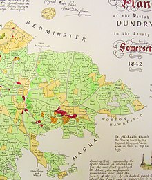
Dundry Hill is immediately south of Bristol, England: it includes farmland, a small number of houses and a church. It stretches east–west for some two miles. Most of the hill is within the district of North Somerset. At the hill's eastern end the southern slopes are within Bath and North East Somerset, and the northern slopes are within the city and county of Bristol, including the highest point in that county.

<span class="mw-page-title-main">Dundry</span> Human settlement in England

Dundry is a village and civil parish, situated on Dundry Hill in the northern part of the Mendip Hills, between Bristol and the Chew Valley Lake, in the English county of Somerset. The parish includes the hamlets of Maiden Head and East Dundry. The parish had a 2011 population of 829.

<span class="mw-page-title-main">Stapleton, Bristol</span> Human settlement in England

Stapleton is an area in the northeastern suburbs of the city of Bristol, England. The name is colloquially used today to describe the ribbon village along Bell Hill and Park Road in the Frome Valley. It borders Eastville to the South and Begbrook and Frenchay to the North. It comprises an eclectic mix of housing mainly from the Victorian, Edwardian, inter-war and late 20th century periods.

<span class="mw-page-title-main">Monarch's Way</span> Long-distance footpath in England

The Monarch's Way is a 625-mile (1,006 km) long-distance footpath in England that approximates the escape route taken by King Charles II in 1651 after being defeated in the Battle of Worcester. It runs from Worcester via Bristol and Yeovil to Shoreham, West Sussex.

<span class="mw-page-title-main">Maes Knoll</span> Iron Age hillfort in Somerset, England

Maes Knoll is an Iron Age hill fort in Somerset, England, located at the eastern end of the Dundry Down ridge, south of the city of Bristol and north of the village of Norton Malreward near the eastern side of Dundry Hill. It is a Scheduled Ancient Monument.

The Chew Valley is an affluent area in North Somerset, England, named after the River Chew, which rises at Chewton Mendip, and joins the River Avon at Keynsham. Technically, the area of the valley is bounded by the water catchment area of the Chew and its tributaries; however, the name Chew Valley is often used less formally to cover other nearby areas, for example, Blagdon Lake and its environs, which by a stricter definition are part of the Yeo Valley. The valley is an area of rich arable and dairy farmland, interspersed with a number of villages.

<span class="mw-page-title-main">Norton Malreward</span> Village and civil parish in Somerset, England

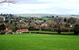
Norton Malreward is a small Somerset village and civil parish 4 miles (6.4 km) south of Bristol, England at the northern edge of the Chew Valley. In 1895 Norton Malreward was combined with the neighbouring hamlet of Norton Hawkfield into a single parish, which has a population of 246.

<span class="mw-page-title-main">Coombe Dingle, Bristol</span> Human settlement in England

Coombe Dingle is a suburb of Bristol, England, centred near where the Hazel Brook tributary of the River Trym emerges from a limestone gorge bisecting the Blaise Castle Estate to join the main course of the Trym. Historically this area formed part of the parish of Westbury on Trym, Gloucestershire, and is now part of Kingsweston ward of the city of Bristol. South of Coombe Dingle is Sea Mills; to the north is Kings Weston Hill; to the west are Kings Weston House and Shirehampton Park; and to the east, Henbury Golf Club and Westbury on Trym proper.

<span class="mw-page-title-main">Blackford, Somerset</span> Human settlement in England

Blackford is a village and former civil parish in the county of Somerset, England, beside the A303 road, 4 miles (6.4 km) south west of Wincanton. There are two other places called Blackford in Somerset: one is a village near Wedmore, the other a tiny hamlet in Selworthy parish between Porlock and Minehead.

<span class="mw-page-title-main">Lawrence Ogilvie</span> Scottish plant pathologist (1898–1980)

Lawrence Ogilvie was a Scottish plant pathologist.

<span class="mw-page-title-main">Henfield, Gloucestershire</span> Human settlement in England

Henfield is a hamlet in South Gloucestershire, England between Coalpit Heath and Westerleigh, adjoining the hamlet of Ram Hill immediately to the north.

<span class="mw-page-title-main">River Malago</span> River in England

The Malago is a tributary of the Bristol Avon in southwestern England, some 5 miles (8.0 km) long. The river rises in springs on the north side of Dundry Hill on the borders of Somerset and Bristol. The main tributary is the Pigeonhouse stream which also rises on Dundry. Much of the river has been culverted as it flows through built-up South Bristol.

Papworth St Agnes is a village and civil parish in South Cambridgeshire, England. The population of the village is included in the civil parish of Graveley It has also been known as Papworth Magna, to distinguish it from the adjoining Papworth Everard and Papworth Parva. The name of the village does not come from any church of St Agnes, but from a certain Agnes de Papewurda, c1160.

Zapudje is a village in the hills south of Dragatuš in the Municipality of Črnomelj in the White Carniola area of southeastern Slovenia. The area is part of the traditional region of Lower Carniola and is now included in the Southeast Slovenia Statistical Region. It includes the hamlet of Golek north of the main settlement.

<span class="mw-page-title-main">Ram Hill</span> Human settlement in England

Ram Hill is a hamlet in South Gloucestershire, England. It is located between Coalpit Heath and Westerleigh and adjoins the hamlet of Henfield immediately to the south. In the Mudge Map 1815, Ram Hill was known as Nutridge Hill, and was linked to Westerleigh by Broad Lane and to Mays Hill by Frog Lane.

<span class="mw-page-title-main">Land Yeo</span> River in north Somerset, England

The Land Yeo is a small river which flows through North Somerset, England. It rises on Dundry Hill and supplies Barrow Gurney Reservoirs before flowing through various villages to Clevedon where it drains into the Severn Estuary. During the past 1,000 years it has powered at least ten watermills, however only one is still functional. Since 2003 initiatives have been undertaken to clean up the river, improving water quality and encouraging wildlife.

<span class="mw-page-title-main">Doris Kathleen Flinn</span> British artist

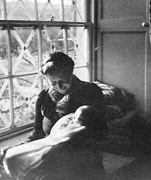
Doris Kathleen Flinn was an English sculptor.

References

  1. Memoirs of Muriel Manning [Spring Farm] as told to Dundry Women's Institute during the 50th anniversary celebrations in 1995. The text was lodged with the Somerset Heritage Centre, Norton Fitzwarren in August 2018.
  2. Bristol Record Office accession 44394
  3. Memoirs of Muriel Manning [Spring Farm] as told to Dundry Women's Institute during the 50th anniversary celebrations in 1995. The text was lodged with the Somerset Heritage Centre, Norton Fitzwarren in August 2018.
  4. Bristol Record Office accession 44394
  5. Ordnance Survey Geology map
  6. See "FARM" on the tithe map
  7. W Duncan Ogilvie (myself) was a child there
  8. W Duncan Ogilvie (myself) was a child there
  9. Inhabitant's childhood night memories.
  10. W Duncan Ogilvie (myself) was a child there
  11. W Duncan Ogilvie (myself) was a child there
  12. W Duncan Ogilvie (myself) was a child there
  13. W Duncan Ogilvie (myself) was a child there
  14. W Duncan Ogilvie (myself) was his child there