The Gunnison River is a tributary of the Colorado River, 164 miles (264 km) long, in the Southwestern state of Colorado. It is the largest tributary of the Colorado River in Colorado, with a mean flow of 2,570 cu ft/s (73 m3/s).

Roaring Fork River is a tributary of the Colorado River, approximately 70 miles (110 km) long, in west central Colorado in the United States. The river drains a populated and economically vital area of the Colorado Western Slope called the Roaring Fork Valley or Roaring Fork Watershed, which includes the resort city of Aspen and the resorts of Aspen/Snowmass.

The Fryingpan River is a tributary of the Roaring Fork River, approximately 42 miles (68 km) long, in west central Colorado in the United States.

White River is a river, approximately 195 miles (314 km) long, in the U.S. states of Colorado and Utah and is a tributary of the Green River.

The Rio Chama, a major tributary river of the Rio Grande, is located in the U.S. states of Colorado and New Mexico. The river is about 130 miles (210 km) long altogether. From its source to El Vado Dam its length is about 50 miles (80 km), from El Vado Dam to Abiquiu Dam is about 51 miles (82 km), and from Abiquiu Dam to its confluence with the Rio Grande is about 34 miles (55 km).
Crow Creek is a 153-mile-long (246 km) waterway of southeastern Wyoming and northern Colorado. Crow Creek is formed by the merger of the South Fork of Crow Creek with the Middle fork of Crow Creek, with the quick addition of the North Fork of Crow Creek about 1.5 miles (2.4 km) downstream. All the major tributaries of Crow Creek begin in the Laramie Range and flow eastward. The headwaters of the North Fork are dammed to form North Crow reservoir, which supplies the city of Cheyenne. The middle fork is also dammed forming Granite and Crystal reservoirs, also supplying water for Cheyenne. The South Fork is the only unobstructed section and flows most of the year but not all the way to Cheyenne. Other tributaries of Crow Creek below the reservoirs are Sand Creek, Spring Creek and Brush Creek, none of which flow year round. Crow Creek continues in an eastward direction passing through the city of Cheyenne, and then heads east and south into Colorado where it eventually meets the South Platte River.
The South Fork White River is a 38.6-mile-long (62.1 km) tributary of the White River. The river's source is in the Flat Tops Wilderness Area of Garfield County, Colorado. It joins with the North Fork White River in Rio Blanco County to form the White River.

East Fork Arkansas River is a 20.6-mile-long (33.2 km) tributary of the Arkansas River that flows from a source in the Mosquito Range of central Colorado. It joins with Tennessee Creek to form the Arkansas River west of Leadville, Colorado.
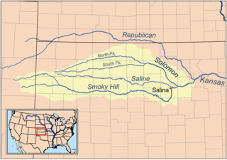
The North Fork Smoky Hill River is a river in the central Great Plains of North America. A tributary of the Smoky Hill River, it flows from eastern Colorado into western Kansas.
West Mancos River is a 13.1-mile-long (21.1 km) tributary of the Mancos River in Montezuma County, Colorado. The river flows from the confluence of its North and South forks in the San Juan National Forest to a confluence with the East Mancos River that forms the Mancos River.

Lake Fork Gunnison River or Lake Fork is a 64.7-mile-long (104.1 km) tributary of the Gunnison River in Colorado. The river's source is Sloan Lake near Handies Peak in the San Juan Mountains of Hinsdale County. Lake Fork flows through Lake San Cristobal and Lake City before a confluence with the Gunnison River in Blue Mesa Reservoir.

South Fork Eagle River is a 6.9-mile-long (11.1 km) tributary of the Eagle River in Eagle County, Colorado. The river flows from a source east of Tennessee Pass in the White River National Forest to a confluence with the East Fork Eagle River that forms the Eagle River.
Middle Fork Cimarron River is a 10.3-mile-long (16.6 km) tributary of the Cimarron River in Colorado. The river's source is east of Coxcomb Peak in the Uncompahgre Wilderness of Hinsdale County. It joins the East Fork Cimarron River in Gunnison County to form the Cimarron River.
West Fork Cimarron River is an 11.8-mile-long (19.0 km) tributary of the Cimarron River in Colorado. The river's source is west of Coxcomb Peak in the Uncompahgre Wilderness of Hinsdale County. It joins the Cimarron River in Gunnison County.
East Fork Cimarron River is a 12.6-mile-long (20.3 km) tributary of the Cimarron River in Colorado. The river's source is near Wetterhorn Peak in the Uncompahgre Wilderness of Hinsdale County. It joins the Middle Fork Cimarron River in Gunnison County to form the Cimarron River, and is impounded by Silver Jack Dam.

The Williams Fork is a tributary of the Colorado River, approximately 33.8 miles (54.4 km) long, in north central Colorado in the United States. It flows through Grand County between the valleys of the Fraser River and the Blue River. It rises at the juncture of McQueary and Bobtail creeks just west of the Continental Divide 8 miles (13 km) west of Berthoud Pass and 7 miles (11 km) north of the Eisenhower Tunnel in the Arapaho National Forest. It flows north-northwest to the Williams Fork Reservoir, then turns northeast and joins the Colorado at Parshall.
North Fork Piney River is a tributary of the Piney River in Eagle County, Colorado. The river flows southwest from a source on the west flank of Elliott Ridge in the White River National Forest to a confluence with the Piney River.
First Fork South Fork Piney River is a tributary of the South Fork Piney River in Eagle County, Colorado. The river flows northeast from a source in the White River National Forest to a confluence with the South Fork Piney River.
Tennessee Creek is a stream in Lake County, Colorado. It rises on the south side of Tennessee Pass near the Eagle County-Lake County line.