
The Gunnison River is a tributary of the Colorado River, 164 miles (264 km) long, in the Southwestern state of Colorado. It is the largest tributary of the Colorado River in Colorado, with a mean flow of 2,570 cu ft/s (73 m3/s).

The Cimarron River extends 698 miles (1,123 km) across New Mexico, Oklahoma, Colorado, and Kansas. The headwaters flow from Johnson Mesa west of Folsom in northeastern New Mexico. Much of the river's length lies in Oklahoma, where it either borders or passes through eleven counties. There are no major cities along its route.The river enters the Oklahoma Panhandle near Kenton, crosses the southeastern corner of Colorado into Kansas, re-enters the Oklahoma Panhandle, re-enters Kansas, and finally returns to Oklahoma where it joins the Arkansas River at Keystone Reservoir west of Tulsa, Oklahoma, its only impoundment. The Cimarron drains a basin that encompasses about 18,927 square miles (49,020 km2).

Curecanti National Recreation Area is a National Park Service unit located on the Gunnison River in western Colorado. Established in 1965, Curecanti is responsible for developing and managing recreational facilities on three reservoirs, Blue Mesa Reservoir, Morrow Point Reservoir and Crystal Reservoir, constructed on the upper Gunnison River in the 1960s by the U.S. Bureau of Reclamation to better utilize the vital waters of the Colorado River and its major tributaries. A popular destination for boating and fishing, Curecanti offers visitors two marinas, traditional and group campgrounds, hiking trails, boat launches, and boat-in campsites. The state's premiere lake trout and Kokanee salmon fisheries, Curecanti is a popular destination for boating and fishing, and is also a popular area for ice-fishing in the winter months.
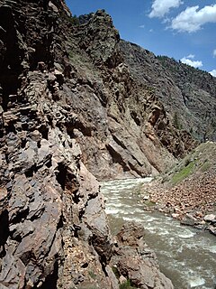
The Cimarron River is a 22.0-mile-long (35.4 km) tributary that joins the Gunnison River in Curecanti National Recreation Area near Cimarron, Colorado. The river's source is the confluence of two forks near Silver Jack Reservoir in the Uncompahgre National Forest.
North Fork Cimarron River is a 169-mile-long (272 km) tributary of the Cimarron River that flows from a source in Comanche National Grassland in Baca County, Colorado. It joins the Cimarron River west of Satanta in Haskell County, Kansas.
Middle Fork Cimarron River is a 10.3-mile-long (16.6 km) tributary of the Cimarron River in Colorado. The river's source is east of Coxcomb Peak in the Uncompahgre Wilderness of Hinsdale County. It joins the East Fork Cimarron River in Gunnison County to form the Cimarron River.
West Fork Cimarron River is an 11.8-mile-long (19.0 km) tributary of the Cimarron River in Colorado. The river's source is west of Coxcomb Peak in the Uncompahgre Wilderness of Hinsdale County. It joins the Cimarron River in Gunnison County.
East Fork Cimarron River is a 12.6-mile-long (20.3 km) tributary of the Cimarron River in Colorado. The river's source is near Wetterhorn Peak in the Uncompahgre Wilderness of Hinsdale County. It joins the Middle Fork Cimarron River in Gunnison County to form the Cimarron River, and is impounded by Silver Jack Dam.

