Rio Grande County is one of the 64 counties of the U.S. state of Colorado. As of the 2010 census, the population was 11,982. The county seat is Del Norte. The county is named for the Rio Grande, which flows through the county.

Chama is a village in Rio Arriba County, New Mexico, United States. The population was 1,022 at the 2010 census. The village is located in the Rocky Mountains about 7 miles (11 km) south of the Colorado-New Mexico border.

The Cumbres & Toltec Scenic Railroad (C&TS) is a 3 ft narrow-gauge heritage railroad running for 64 miles (103 km) between Antonito, Colorado and Chama, New Mexico, United States. The railroad gets its name from two geographical features along the route, the 10,015-foot (3,053 m)-high Cumbres Pass and the Toltec Gorge. Originally part of the Denver and Rio Grande Western Railroad's narrow-gauge network, the line has been jointly owned by the states of Colorado and New Mexico since 1970.

The Rio Chama, a major tributary river of the Rio Grande, is located in the U.S. states of Colorado and New Mexico. The river is about 130 miles (210 km) long altogether. From its source to El Vado Dam its length is about 50 miles (80 km), from El Vado Dam to Abiquiu Dam is about 51 miles (82 km), and from Abiquiu Dam to its confluence with the Rio Grande is about 34 miles (55 km).

The Brazos Mountains is a range in far northern Rio Arriba County, in northern New Mexico in the southwestern United States. The range is part of the southern portion of the San Juan Mountains which are more well known in Colorado. A high crest runs from the border with Colorado for over 20 miles (32 km) in a south-southeasterly direction. The high point of the range at 11,405 feet (3,476 m) is on Grouse Mesa, at the Brazos Benchmark. Two miles (3 km) to the southeast is the more distinctive Brazos Peak, at 11,288 feet.

Alpine is a census-designated place located in Rio Grande County, Colorado, United States. ZIP code 81154 serves Alpine, but mail must be addressed to South Fork.

The Piedra River is a river in the U.S. state of Colorado. It drains parts of Archuleta, Hinsdale, and Mineral counties along a mainstem length of about 40 miles (64 km). The river flows through a series of isolated box canyons, emptying into the San Juan River at Navajo Lake. Its name stems from the Spanish word, piedra, meaning rock.
New Mexico State Road 17 (NM 17) is a state highway in Rio Arriba County, New Mexico. Its southern end is at US 64-84 in Chama and its northern end is at Colorado State Highway 17 at the Colorado state line.
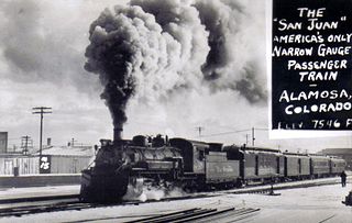
The San Juan Express was a narrow gauge train that ran on the 3 feet (0.91 m) Denver & Rio Grande Western Railroad (D&RGW) route from Durango, Colorado via Chama, New Mexico; Cumbres Pass; and Antonito, Colorado to Alamosa, Colorado. The train ran from February 11, 1937 until January 31, 1951 as train numbers 115 and 116, though towards the end of the passenger service it took on the number 215 and 216.
Sublette is a railroad town in northern Rio Arriba County, New Mexico, built as a section station in 1880. It is located north-east of Chama, just south of the Colorado state line and at milepost 306.1 of the former Denver and Rio Grande Western Railroad. When the Denver & Rio Grande Western Railroad abandoned its narrow gauge lines in the late 1960s, two parts of the system were preserved independently: the Cumbres & Toltec Scenic Railroad from Antonito to Chama, including Sublette itself, and the Durango and Silverton Narrow Gauge Railroad. Sublette sits at an elevation of 9,281 feet in the southeastern San Juan Mountains.

Navajo River is a 54-mile-long (87 km) tributary of the San Juan River. It flows from a source in the South San Juan Wilderness of Conejos County, Colorado southwest past Chromo, Colorado. The river dips into New Mexico, passing just north of Dulce before heading northwest to a confluence with the San Juan in Archuleta County, Colorado. A large portion of its water is diverted across the Continental Divide to the Rio Grande basin as part of the San Juan-Chama Project.

The San Juan-Chama Project is a U.S. Bureau of Reclamation interbasin water transfer project located in the states of New Mexico and Colorado in the United States. The project consists of a series of tunnels and diversions that take water from the drainage basin of the San Juan River – a tributary of the Colorado River – to supplement water resources in the Rio Grande watershed. The project furnishes water for irrigation and municipal water supply to cities along the Rio Grande including Albuquerque and Santa Fe.

Heron Dam is a storage dam Rio Arriba County, in northern New Mexico in the southwestern United States, just north of the El Vado Dam. It is owned and operated by the United States Bureau of Reclamation. The dam is about 9 miles west of the town of Tierra Amarilla.
The Rio Brazos is a 42-mile (68 km) long river flowing through northern New Mexico in the United States. It rises in the Tusas Mountains, a subrange of the San Juan Mountains, and runs generally southwest to a confluence with the Rio Chama, part of the larger Rio Grande system.
Rio Chamita is a tributary of the Rio Chama in the United States. The stream flows south from a source in Archuleta County, Colorado to a confluence with the Rio Chama in Rio Arriba County, New Mexico.