
The South Platte River is one of the two principal tributaries of the Platte River. Flowing through the U.S. states of Colorado and Nebraska, it is itself a major river of the American Midwest and the American Southwest/Mountain West. Its drainage basin includes much of the eastern flank of the Rocky Mountains in Colorado; much of the populated region known as the Colorado Front Range and Eastern Plains; and a portion of southeastern Wyoming in the vicinity of the city of Cheyenne. It joins the North Platte River in western Nebraska to form the Platte, which then flows across Nebraska to the Missouri. The river serves as the principal source of water for eastern Colorado. In its valley along the foothills in Colorado, it has permitted agriculture in an area of the Colorado Piedmont and Great Plains that is otherwise arid.

The Gunnison River is a tributary of the Colorado River, 164 miles (264 km) long, in the Southwestern state of Colorado. It is the largest tributary of the Colorado River in Colorado, with a mean flow of 2,570 cu ft/s (73 m3/s).

Roaring Fork River is a tributary of the Colorado River, approximately 70 miles (110 km) long, in west central Colorado in the United States. The river drains a populated and economically vital area of the Colorado Western Slope called the Roaring Fork Valley or Roaring Fork Watershed, which includes the resort city of Aspen and the resorts of Aspen/Snowmass.

The Crystal River is a tributary of the Roaring Fork River, approximately 40 mi (64 km) long, in western Colorado in the United States. It drains a glacial valley, called the Coal Basin, south of Carbondale which was historically known as a center of coal mining in southwestern Colorado. It rises in northern Gunnison County in the Elk Mountains on the north side of Schofield Pass, passing through the ghost town of Crystal City, still inhabited by a few summer residents. It then flows north past Marble, then into Pitkin County past Redstone. It joins the Roaring Fork below Carbondale. State Highway 133 follows the river along much of its route north of Marble.

The Elk Mountains are a high, rugged mountain range in the Rocky Mountains of west-central Colorado in the United States. The mountains sit on the western side of the Continental Divide, largely in southern Pitkin and northern Gunnison counties, in the area southwest of Aspen, south of the Roaring Fork River valley, and east of the Crystal River. The range sits west of the Sawatch Range and northeast of the West Elk Mountains. Much of the range is located within the White River National Forest and the Gunnison National Forest, as well as the Maroon Bells-Snowmass Wilderness and Raggeds Wilderness. The Elk Mountains rise nearly 9,000 ft. above the Roaring Fork Valley to the north.
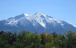
Mount Sopris is a twin-summit mountain in the northwestern Elk Mountains range of the Rocky Mountains of North America. The 12,965-foot (3,952 m) mountain is located in the Maroon Bells-Snowmass Wilderness of White River National Forest, 6.6 miles (10.7 km) north by northeast of the community of Redstone in Pitkin County, Colorado, United States.

Snowmass Mountain is a fourteen thousand foot mountain in the U.S. state of Colorado and the thirty-fourth highest mountain peak in the state. Located in the Elk Mountains, within the Maroon Bells-Snowmass Wilderness of the White River National Forest, it lies along the border between Pitkin and Gunnison counties, west of Aspen and southwest of the town of Snowmass Village.

Curecanti National Recreation Area is a National Park Service unit located on the Gunnison River in western Colorado. Established in 1965, Curecanti is responsible for developing and managing recreational facilities on three reservoirs, Blue Mesa Reservoir, Morrow Point Reservoir and Crystal Reservoir, constructed on the upper Gunnison River in the 1960s by the U.S. Bureau of Reclamation to better utilize the vital waters of the Colorado River and its major tributaries. A popular destination for boating and fishing, Curecanti offers visitors two marinas, traditional and group campgrounds, hiking trails, boat launches, and boat-in campsites. The state's premiere lake trout and Kokanee salmon fisheries, Curecanti is a popular destination for boating and fishing, and is also a popular area for ice-fishing in the winter months.

The Roaring Fork Valley is a geographical region in western Colorado in the United States. The Roaring Fork Valley is one of the most affluent regions in Colorado and the U.S. as well as one of the most populous and economically vital areas of the Colorado Western Slope. The Valley is defined by the valley of the Roaring Fork River and its tributaries, including the Crystal and Fryingpan River. It includes the communities of Aspen, Snowmass Village, Basalt, Carbondale, and Glenwood Springs. Mount Sopris and the Roaring Fork River serve as symbols of the Roaring Fork Valley.

State Highway 82 is an 85.3-mile-long (137.3 km) state highway in the U.S. state of Colorado. Its western half provides the principal transportation artery of the Roaring Fork Valley on the Colorado Western Slope, beginning at Interstate 70 (I-70) and U.S. Highway 6 in Glenwood Springs southeast past Carbondale, Basalt and Aspen. From there it continues up the valley to cross the Continental Divide at Independence Pass. On the Eastern Slope, it follows Lake Creek past some of Colorado's highest mountains to Twin Lakes Reservoir, where it ends at US 24 south of Leadville.

The Collegiate Peaks Wilderness is a 168,000-acre (680 km2) area located in central Colorado between Leadville and Buena Vista to the east and Aspen to the west and Crested Butte to the southwest. Most of the area is in the San Isabel and Gunnison National Forests, with a smaller area in the White River National Forest southeast of Aspen. Most of the area is in northwest Chaffee County with smaller portions in Gunnison, Pitkin, and Lake counties.

Crystal is a ghost town on the upper Crystal River in Gunnison County, Colorado, United States. It is located in the Elk Mountains along a four-wheel-drive road 6 miles (9.7 km) east of Marble and 20 miles (32 km) northwest of Crested Butte. Crystal was a mining camp established in 1881 and after several decades of robust existence, was all but abandoned by 1917. Many buildings still stand in Crystal, but its few residents live there only in the summer.
Crow Creek is a 153-mile-long (246 km) waterway of southeastern Wyoming and northern Colorado. Crow Creek is formed by the merger of the South Fork of Crow Creek with the Middle fork of Crow Creek, with the quick addition of the North Fork of Crow Creek about 1.5 miles (2.4 km) downstream. All the major tributaries of Crow Creek begin in the Laramie Range and flow eastward. The headwaters of the North Fork are dammed to form North Crow reservoir, which supplies the city of Cheyenne. The middle fork is also dammed forming Granite and Crystal reservoirs, also supplying water for Cheyenne. The South Fork is the only unobstructed section and flows most of the year but not all the way to Cheyenne. Other tributaries of Crow Creek below the reservoirs are Sand Creek, Spring Creek and Brush Creek, none of which flow year round. Crow Creek continues in an eastward direction passing through the city of Cheyenne, and then heads east and south into Colorado where it eventually meets the South Platte River.
North Fork Crystal River is a tributary of the Crystal RIver in Gunnison County, Colorado. The stream flows from a source in the Maroon Bells-Snowmass Wilderness to a confluence with the South Fork Crystal River in the White River National Forest that forms the Crystal River. Class VI rapids not usually run, do not attempt to run at peak or high flows. Short but very continuous whitewater.

