East Missoula, Montana

Last updated

East Missoula, Montana
East Missoula - panoramio.jpg
East Missoula, Montana
Missoula County Montana Incorporated and Unincorporated areas East Missoula Highlighted.svg
Location in Missoula County and the state of Montana
Coordinates: 46°52′30″N113°56′29″W / 46.87500°N 113.94139°W / 46.87500; -113.94139
Country United States
State Montana
County Missoula
Area
[1]
  Total1.25 sq mi (3.23 km2)
  Land1.21 sq mi (3.12 km2)
  Water0.04 sq mi (0.11 km2)
Elevation
3,264 ft (995 m)
Population
 (2020) [2]
  Total2,465
Time zone UTC-7 (Mountain (MST))
  Summer (DST) UTC-6 (MDT)
ZIP code
59802 (Missoula)
Area code 406
FIPS code 30-23200
GNIS feature ID0782938

East Missoula is an unincorporated community and census-designated place (CDP) in Missoula County, Montana, United States. It is part of the Missoula metropolitan area. The population was 2,465 at the 2020 census, [2] up from 2,157 in 2010.

Contents

Geography

East Missoula is located in central Missoula County at 46°52′30″N113°56′29″W / 46.87500°N 113.94139°W / 46.87500; -113.94139 (46.875110, -113.941269). [3] It is bordered to the west by the city of Missoula. The Clark Fork River borders the community to the east, across which is an exclave of Missoula. Former U.S. Route 10 and Montana Highway 200 pass through the center of East Missoula, while Interstate 90 runs along the southern edge of the community, with access from Exit 107.

According to the U.S. Census Bureau, the East Missoula CDP has a total area of 1.25 square miles (3.2 km2), of which 1.21 square miles (3.1 km2) are land and 0.04 square miles (0.10 km2), or 3.29%, are water. [1]

Climate

This climatic region is typified by large seasonal temperature differences, with warm to hot (and often humid) summers and cold (sometimes severely cold) winters. According to the Köppen Climate Classification system, East Missoula has a humid continental climate, abbreviated "Dfb" on climate maps. [4]

Demographics

Historical population
CensusPop.Note
1980 1,707
2000 2,070
2010 2,1564.2%
2020 2,46514.3%
U.S. Decennial Census [5]

As of the census [6] of 2010, there were 2,157 people, 795 households, and 519 families residing in the CDP. The population density was 1,514.1 inhabitants per square mile (584.6/km2). There were 828 housing units at an average density of 605.6 per square mile (233.8/km2). The racial makeup of the CDP was 93.57% White, 0.34% African American, 3.24% Native American, 0.48% Asian, 0.24% from other races, and 2.13% from two or more races. Hispanic or Latino of any race were 1.64% of the population.

There were 795 households, out of which 33.0% had children under the age of 18 living with them, 48.6% were married couples living together, 11.6% had a female householder with no husband present, and 34.6% were non-families. 26.2% of all households were made up of individuals, and 6.3% had someone living alone who was 65 years of age or older. The average household size was 2.50 and the average family size was 3.01.

In the CDP, the population was spread out, with 24.3% under the age of 18, 10.3% from 18 to 24, 31.8% from 25 to 44, 22.9% from 45 to 64, and 10.7% who were 65 years of age or older. The median age was 36 years. For every 100 females, there were 105.0 males. For every 100 females age 18 and over, there were 104.2 males.

The median income for a household in the CDP was $27,094, and the median income for a family was $38,464. Males had a median income of $26,150 versus $18,000 for females. The per capita income for the CDP was $13,333. About 7.6% of families and 13.6% of the population were below the poverty line, including 5.0% of those under age 18 and 8.8% of those age 65 or over.

Education

A portion of East Missoula is in Bonner Elementary School District while the other portion is in Missoula Elementary School District. All of it is in Missoula High School District. [7]

Related Research Articles

<span class="mw-page-title-main">Waikoloa Village, Hawaii</span> Census-designated place in Hawaii, U.S.

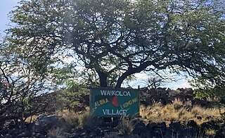
Waikōloa Village is a census-designated place (CDP) in Hawaiʻi County, Hawaii, United States. The population was 6,362 at the 2010 census, up from 4,806 at the 2000 census. The name Waikoloa is used by the local post office.

<span class="mw-page-title-main">Busby, Montana</span> Census-designated place in Big Horn County, Montana, United States

Busby is a census-designated place (CDP) in Big Horn County, Montana, United States. It is on the Northern Cheyenne reservation. The population was 745 at the 2010 census.

<span class="mw-page-title-main">Radersburg, Montana</span> Village in Montana, United States

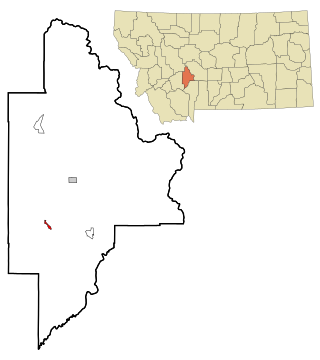
Radersburg is an unincorporated rural village in Broadwater County, Montana, United States.

<span class="mw-page-title-main">Black Eagle, Montana</span> CDP in Montana, United States

Black Eagle is a census-designated place (CDP) in Cascade County, Montana, United States. The population was 904 at the 2010 census. It is a suburb of Great Falls.

<span class="mw-page-title-main">Four Corners, Montana</span> Census-designated place in Montana, United States

Four Corners is a census-designated place (CDP) in Gallatin County, Montana, United States. The population was 5,901 at the 2020 census, up from 3,146 in 2010. It is part of the Bozeman, MT Micropolitan Statistical Area.

<span class="mw-page-title-main">Ravalli, Montana</span> Place in Montana, United States

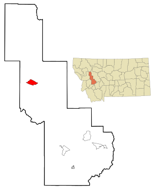
Ravalli is an unincorporated community in Lake County, Montana, United States. The population was 76 at the 2010 census, down from 119 in 2000. For statistical purposes, the United States Census Bureau has defined Ravalli as a census-designated place (CDP). In the early 1900s, the Pablo-Allard herd in Ravalli was said to be the largest collection of the bison remaining in the U.S. and played a critical role in the conservation of bison.

<span class="mw-page-title-main">Augusta, Montana</span> Census-designated place in Montana, United States

Augusta is an unincorporated community and census-designated place (CDP) in Lewis and Clark County, Montana, United States. The population was 309 at the 2010 census and rose to 316 in the 2020 census. The most accepted version in the naming of this town is after Augusta Hogan, thought to be the first child born in this town, the daughter of J. D. Hogan, an early rancher.

<span class="mw-page-title-main">Helena Valley Northeast, Montana</span> Census-designated place in Montana, United States

Helena Valley Northeast is a census-designated place (CDP) in Lewis and Clark County, Montana, United States. The population was 2,995 at the 2010 census. It is part of the Helena Micropolitan Statistical Area.

<span class="mw-page-title-main">Lincoln, Montana</span> Census-designated place in Montana, United States

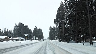
Lincoln is an unincorporated community and census-designated place (CDP) in Lewis and Clark County, Montana, United States. As of the 2010 census, the population was 1,013.

<span class="mw-page-title-main">St. Regis, Montana</span> Census-designated place in Montana, United States

St. Regis or Saint Regis is an unincorporated community and census-designated place (CDP) in Mineral County, Montana. The population was 313 at the time of the 2020 census.

<span class="mw-page-title-main">Bonner-West Riverside, Montana</span> Census-designated place in Montana, United States

Bonner-West Riverside is a census-designated place (CDP) in Missoula County, Montana, United States, including the unincorporated communities of Bonner, Milltown, West Riverside, and Pinegrove. It is part of the Missoula metropolitan area. The population was 1,690 at the 2020 census.

<span class="mw-page-title-main">Clinton, Montana</span> Census-designated place in Montana, United States

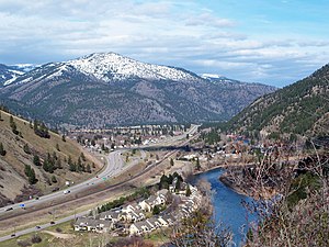
Clinton is an unincorporated community and census-designated place (CDP) in Missoula County, Montana, United States. It is part of the Missoula metropolitan area. The population was 1,018 at the 2020 census.

<span class="mw-page-title-main">Evaro, Montana</span> Census-designated place in Montana, United States

Evaro is a census-designated place (CDP) in Missoula County, Montana, United States, and part of the Missoula metropolitan area. It is located on the southernmost part of the Flathead Indian Reservation, approximately 20 miles (32 km) north of downtown Missoula via US Highway 93. As of the 2020 census, the population of the CDP was 373, up from 322 in 2010.

<span class="mw-page-title-main">Lolo, Montana</span> Census-designated place in Montana, United States

Lolo is an unincorporated community and census-designated place (CDP) in Missoula County, Montana, United States. It is part of the Missoula metropolitan area. The population was 4,399 at the 2020 census, an increase from its population of 3,892 in 2010. It is home to Travelers' Rest State Park, a site where Lewis and Clark camped in 1805 and again in 1806.

<span class="mw-page-title-main">Orchard Homes, Montana</span> Census-designated place in Montana, United States

Orchard Homes is a census-designated place (CDP) in Missoula County, Montana, United States. It is part of the Missoula metropolitan area. The population was 5,377 at the 2020 census.

<span class="mw-page-title-main">Seeley Lake, Montana</span> Census-designated place in Montana, United States

Seeley Lake is an unincorporated community and census-designated place (CDP) in Missoula County, Montana, United States. It is part of the Missoula metropolitan area. The town sits beside the 1,030-acre (420 ha) Seeley Lake. The population was 1,682 at the 2020 census.

<span class="mw-page-title-main">Wye, Montana</span> Place in Montana, United States

Wye is an unincorporated community in Missoula County, Montana, United States. It is part of the Missoula, Montana Metropolitan Statistical Area. The population was 511 at the 2010 census, an increase from its population of 381 in 2000. For statistical purposes, the United States Census Bureau has defined Wye as a census-designated place (CDP). Wye is named for the "y"-shaped DeSmet Junction where US 93 and MT 200 met former US 10.

<span class="mw-page-title-main">Avon, Montana</span> CDP in Montana, United States

Avon is a census-designated place (CDP) in Powell County, Montana, United States. The population was 124 at the 2000 census. The town sits along the Little Blackfoot River, and serves as a gateway to the Beaverhead-Deerlodge National Forest.

<span class="mw-page-title-main">Ovando, Montana</span> CDP in Montana, United States

Ovando is a census-designated place (CDP) in Powell County, Montana, United States. It is approximately fifty-four miles ENE of Missoula, Montana. The population was 71 at the 2000 census.

Box Elder is an unincorporated community and census-designated place (CDP) in Hill County in the U.S. state of Montana. The population was 87 at the 2010 census. The population was 794 at the 2000 census, but before 2010 the Box Elder CDP was split into the current much-smaller Box Elder CDP, while most of the former CDP area went into the new Rocky Boy West CDP. Box Elder is the headquarters of the Chippewa-Cree tribe.

References

  1. 1 2 "2023 U.S. Gazetteer Files: Montana". United States Census Bureau. Retrieved May 31, 2024.
  2. 1 2 "P1. Race – East Missoula CDP, Montana: 2020 DEC Redistricting Data (PL 94-171)". U.S. Census Bureau. Retrieved May 31, 2024.
  3. "US Gazetteer files: 2010, 2000, and 1990". United States Census Bureau. February 12, 2011. Retrieved April 23, 2011.
  4. Climate Summary for East Missoula, Montana
  5. "Census of Population and Housing". Census.gov. Retrieved June 4, 2016.
  6. "U.S. Census website". United States Census Bureau . Retrieved January 31, 2008.
  7. "2020 CENSUS - SCHOOL DISTRICT REFERENCE MAP: Missoula County, MT" (PDF). U.S. Census Bureau . Retrieved March 13, 2024.