Related Research Articles
The Embarcadero in San Diego, California is the area along the San Diego harbor on the east side of San Diego Bay. "Embarcadero" is a Spanish word meaning "boarding place". The Embarcadero sits on property administered by the Port of San Diego, in the Columbia district of Downtown San Diego.

Hillcrest is an uptown neighborhood in San Diego, California. The area is located north-northwest of Balboa Park, south of Interstate 8/Mission Valley, with Park Boulevard to the east and First Avenue to the west.

North Park is a neighborhood in San Diego, California, United States, as well as a larger "community" as defined by the City of San Diego for planning purposes. The neighborhood is bounded:

Normal Heights is a neighborhood of the mid-city region of San Diego, California.

Logan Heights is an urban neighborhood in central San Diego, California. It is bordered by Interstate 5 on the south and west, Interstate 15 on the east, and Imperial Avenue on the north. It is part of the Southeastern Planning Area.

Barrio Logan is a neighborhood in south central San Diego, California. It is bordered by the neighborhoods of East Village and Logan Heights to the north, Shelltown and Southcrest to the east, San Diego Bay to the southwest, and National City to the southeast. Interstate 5 forms the northeastern boundary. The Barrio Logan Community Plan Area comprises approximately 1,000 acres, of which slightly more than half is under the jurisdiction of the Port of San Diego or the United States Navy rather than the city of San Diego. The community is subject to the California Coastal Act. Though located near the City's Central core, it has long been considered part of Southeast San Diego by many locals, being directly Southeast of Downtown, and with previous historical records labeling it as part of "Western Southeast San Diego."
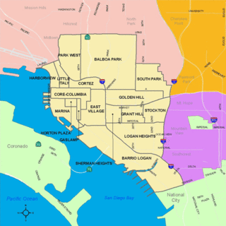
Golden Hill is a neighborhood of San Diego, California. It is located south of Balboa Park, north of Sherman Heights, Grant Hill and Stockton, and east of Downtown.

Bankers Hill, also known as Park West and formerly known as Florence Heights, is a long-established uptown San Diego neighborhood near Balboa Park. It is bordered to the north by Hillcrest at Upas Street, to the south by Downtown, to the east by Balboa Park, and to the west by Interstate 5, Little Italy and the neighborhood known as Midtown. A more constricted definition of the neighborhood sets its eastern boundary as Fourth Avenue and its western boundary as First Avenue.
Talmadge is a neighborhood of the mid-city region of San Diego, California. Its borders are defined differently by various planning agencies, but typically include Fairmount Avenue to the west, Montezuma Road to the north, Collwood Boulevard or 51st Street to the east, and Monroe Avenue or El Cajon Boulevard to the South.

Columbia is a neighborhood located in Downtown San Diego, California. The neighborhood is largely commercial, however there are many highrise condominium buildings under construction.

Cortez Hill is a neighborhood located in the northeast part of Downtown San Diego, California.

The Azalea Park neighborhood is a community within City Heights in the greater San Diego, California area. It is located on top of a plateau 3 miles east of San Diego Bay, with an elevation of around 300 feet. It is bordered to the north by Manzanita Canyon Fairmount Avenue to the east, Interstate 805 to the west, and Hollywood Park to the south.
Loma Portal is a neighborhood in the community of Point Loma in San Diego, California. It is a hilly area northwest of Rosecrans Street and northeast of Nimitz Boulevard, overlooking San Diego Bay.
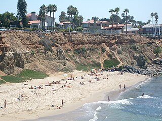
Sunset Cliffs is an affluent coastal community in the Point Loma community of San Diego, California. It is bordered by the Pacific Ocean on the west, Ocean Beach on the north, Catalina Blvd. and Santa Barbara St. on the east, and Sunset Cliffs Natural Park on the south.

Grant Hill is a neighborhood in central San Diego, California bordered by Golden Hill to the north, Stockton to the east, Sherman Heights to the west, and Logan Heights to the south. 30th Street connects Grant Hill to the neighborhood of Golden Hill. Grant Hill is part of the Southeastern Planning Area.
Sherman Heights is an urban neighborhood in central San Diego bordered by Golden Hill to the north, Grant Hill to the east, East Village to the west, and Logan Heights to the south. It is part of the Southeastern Planning Area.
Nestor is a residential neighborhood in the southern section of San Diego, and part of the Otay Mesa-Nestor community planning area. It neighbors Palm City and Otay Mesa West to the east, Egger Highlands to the north, San Ysidro to the southeast and the Tijuana River Valley to the south. Major thoroughfares include Coronado Avenue, Saturn Boulevard, Hollister Street, and Tocayo Avenue.

Emerald Hills is a neighborhood in the southeastern section of the city of San Diego, California, United States. It is bordered by Oak Park and California State Route 94 on the north, Chollas View and Euclid Avenue on the west, Encanto and Skyline Drive on the east, and Valencia Park and Market Street on the south. Major thoroughfares include Kelton Road and Roswell Street.

Broadway Heights is a small community in the southeastern section of the city of San Diego. It is bordered on the north, east, and west by Lemon Grove, and on the south by Encanto and Mallard Street. The predominantly African-American community has 629 residents within its seven blocks. Weston Street was renamed to Martin Luther King Jr. Way due to a youth campaign, marking the first time a street in San Diego was named after him.

The Asian Pacific Thematic Historic District (APTHD), San Diego's historic Chinatown, is an eight-block district adjacent to and in part overlapping with the Gaslamp Quarter Historic District. The APTHD is bounded by Market Street on the north, 2nd Ave. on the west, 6th Ave. on the east and J St. on the south. 22 structures are considered historically contributing.
References
- ↑ "San Diego Then & Now — The Bank of East San Diego". Russell Ray Photos. Retrieved January 16, 2014.
- 1 2 3 Kramer, Ken (January 24, 2013). "Episode 56". About San Diego. KPBS-TV. Retrieved January 16, 2014.