
Malden is a city in Middlesex County, Massachusetts, United States. As of 2018, the population was 61,036 people.

Melrose is a city located in the Greater Boston metropolitan area in Middlesex County, Massachusetts, United States. Its population, per the 2010 United States Census, is 26,983. It is a suburb located approximately seven miles north of Boston. It is situated in the center of the triangle created by Interstates 93, 95 and U.S. Route 1.
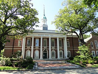
Weston is a town in Middlesex County, Massachusetts, about 15 miles west of downtown Boston. The population of Weston, as of June 2017, was 11,389.

Chelsea is a city in Suffolk County, Massachusetts, United States, directly across the Mystic River from the city of Boston. As of the 2010 census, Chelsea had a population of 35,177. It is also the second most densely populated city in Massachusetts behind Somerville. With a total area of just 2.46 square miles, Chelsea is the smallest city in Massachusetts in terms of total area.

Nahant is a town in Essex County, Massachusetts, United States. The population was 3,410 at the 2010 census, which makes it the smallest municipality by population in Essex County. With just 1.0 square mile (2.7 km2) of land area, it is the smallest municipality by area in the state. It is primarily a residential community. The town is situated on peninsula consisting of two near-islands connected to the mainland by a narrow sandy isthmus traversed by a single causeway known as "Nahant Road". Numerous tourist beaches line the shores, with the most popular being the so-called "Long Beach" and "Short Beach" along the eastern side of the causeway.
Saugus is a town in Essex County, Massachusetts, United States, in the Greater Boston area. The population was 26,628 at the 2010 census.

Wakefield is a town in Middlesex County, Massachusetts in the Greater Boston metropolitan area, incorporated in 1812 and located about 12.5 mi (20.1 km) north-northwest of Downtown Boston. The 73rd most populous municipality in Massachusetts, Wakefield's population was 24,932 at the 2010 census, with a 2016 population estimate of 26,399. Wakefield offers an assortment of activities around the local lake, Lake Quannapowitt.

Auburndale, sometimes nicknamed the Dale by residents, is one of the thirteen villages within the city of Newton in Middlesex County, Massachusetts, United States. It lies at the western end of Newton near the intersection of interstate highways 90 and 95. It is bisected by the Massachusetts Turnpike. Auburndale is surrounded by three other Newton villages as well as the city of Waltham and the Charles River. Auburndale is the home of Williams and Burr elementary schools, as well as Lasell College. Auburndale Square is the location of the Plummer Memorial Library, which is run by the Auburndale Community Library and no longer affiliated with the Newton Free Library, the Turtle Lane Playhouse, and many small businesses.

Oak Grove station is a rapid transit station in Malden, Massachusetts. It serves the MBTA Orange Line, and located in northern Malden just south of the Melrose border. The northern terminus of the Orange Line, Oak Grove has a 788-space park and ride lot serving nearby residential communities. It is also served by four MBTA bus routes and has secure cages for bicycle storage. Like all Orange Line stations, Oak Grove is accessible.

Wollaston, Massachusetts, is a neighborhood in the city of Quincy, Massachusetts. Divided by Hancock Street or Route 3A, the Wollaston Beach side is known as Wollaston Park, while the Wollaston Hill side is known as Wollaston Heights.

Malden Center is an intermodal transit station in Malden, Massachusetts. Located on an elevated grade above Pleasant Street in downtown Malden, it serves the MBTA's rapid transit Orange Line and the MBTA Commuter Rail Haverhill Line, as well as 13 MBTA bus routes. The current station opened on December 27, 1975, replacing an older brick station which has since been repurposed as a restaurant.

Sullivan Square is a rapid transit station in Boston, Massachusetts. It serves the MBTA's Orange Line, and is also a major bus transfer point. It is located just west of the Sullivan Square traffic circle in the Charlestown neighborhood, adjacent to East Somerville. The modern subway station was built in 1975, and replaced an earlier Charlestown Elevated station established in 1901.
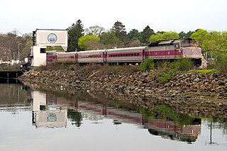
The Newburyport/Rockport Line is a branch of the MBTA Commuter Rail system, running northeast from downtown Boston, Massachusetts towards Cape Ann and the Merrimack Valley, serving the North Shore. The first leg, operating via the Eastern Route of the former Boston and Maine Railroad, serves Chelsea, Lynn, Swampscott, Salem, and Beverly. From there, a northern branch continues via the Eastern Route to serve Hamilton, Ipswich, Rowley, and Newburyport, while other trains operate east from Beverly via the Gloucester Branch, serving Manchester, Gloucester, and Rockport. A bicycle coach is offered on the Rockport branch during the summer.

Melrose/Cedar Park is an MBTA Commuter Rail station located in downtown Melrose, Massachusetts. The station has two low-level platforms serving the two tracks of the Haverhill Line; it is not accessible.

Melrose Highlands is one of the oldest neighborhoods in the city of Melrose, Massachusetts. Formerly part of neighboring Stoneham, it became part of Melrose in the latter part of the nineteenth century. There were some addresses that had the zip code 02177, before the Highlands post office was closed; the Melrose zip code of 02176 is now used, although mail marked as 02177 is still deliverable.
Mount Hood is an 18 hole golf club and park located in Melrose, Massachusetts. It was built in the 1930s on donated land as part of President Franklin D. Roosevelt's Works Progress Administration and once consisted of a ski area. Today, Mount Hood serves as a golf course and park, while sledding is popular in the winter.

Lynn station is an intermodal transit station in downtown Lynn, Massachusetts. It is a station on the MBTA Commuter Rail Newburyport/Rockport Line and a hub for the MBTA bus system. The station consists of a single center island platform serving the two station tracks on an elevated grade. A large parking garage is integrated into the station structure.

Furnace Brook Parkway is a historic parkway in Quincy, Massachusetts. Part of the Metropolitan Park System of Greater Boston, it serves as a connector between the Blue Hills Reservation and Quincy Shore Reservation at Quincy Bay. First conceived in the late nineteenth century, the state parkway is owned and maintained by the Massachusetts Department of Conservation and Recreation (DCR) and travels through land formerly owned by the families of John Adams and John Quincy Adams, passing several historic sites. It ends in the Merrymount neighborhood, where Quincy was first settled by Europeans in 1625 by Captain Richard Wollaston. The road was started in 1904, completed in 1916 and added to the National Register of Historic Places (NRHP) in 2004.

Chiswick Road station is a light rail station on the MBTA's Green Line B branch, located in the median of Commonwealth Avenue north of Chiswick Road in the Brighton neighborhood of Boston, Massachusetts. Chiswick Road consists of two side platforms, which serve the B branch's two tracks.

The Saugus Branch Railroad was an American rail line that operated passenger service from 1853 to 1958. It serviced the Massachusetts communities of Saugus, Malden, Everett, Revere, and Lynn.