East Wall is bounded by West Road to the west, by Sheriff Street Upper to the south, and was bounded by East Wall Road to the north until land reclamation extended that part. It is linked to Ringsend by the East-Link bridge; it is linked to Fairview by Annesley Bridge. The broader region is bounded by Railway lines, the Royal Canal, the River Tolka, the River Liffey and Dublin Port (the Irish Sea), taking in the Dublin Docklands, resulting in a readily identifiable area geographically if somewhat separated from the large city which surrounds it.[1] The southern entrance to the Dublin Port Tunnel is in East Wall.
History and development
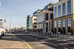
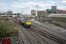
Apartments in East WallEast Wall train yard
East Wall dates from the end of the eighteenth century to the time of the construction of the North Wall. It was originally a working-class area, with many finding employment in Dublin Port, adjacent to the area.
On 25 June 1970, the timberyard of James McMahon on East Wall Road caught on fire causing damages amounting to £1 million and two days later, on 27 June, a diesel store warehouse located beside a block of 9 shops on Church Road was set alight with the fire spreading and gutting each shop.[2] This was part of a series of fires in the city in 1970.
In the economic boom years from the late 1990s onwards, the area developed rapidly, with the notable addition of the International Financial Services Centre (mostly in neighbouring North Wall), and East Point Business Park on reclaimed land extending East Wall to the north. It has developed rapidly since the late 1990s, and in 2013 regained its status as an officially recognised village within the framework of the Dublin City Development Plan. There has been an increase in the population in recent years to over 5,000.[citation needed] It now contains a number of social organisations across cultural, arts & sporting interests, and it has an award-winning community cultural centre, The Sean O'Casey Centre, which is named after one of its most famous past residents, Seán O'Casey.[3] New businesses have located in the area in recent years.[when?] It is located close to the port area, the financial district and with ease of access to Dublin airport.[citation needed]
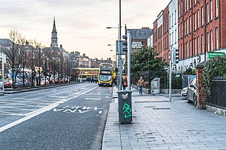
Amenities
Sean O'Casey Community Centre
East Wall is primarily a residential neighbourhood of around 1,800 households, with a population of approximately 5,000.[citation needed] The area is serviced by shops, St. Joseph's Church, the Sean O'Casey Community Centre, a primary school and recreational facilities (parks, sea and beach) within walking distance. The community centre includes a sports hall, a theatre and a football pitch.[3]St. Barnabas' Church, Dublin would have provided services for Church of Ireland parishioners, such as Seán O'Casey until it closed in 1965 and the parish merged with that of North Strand. There is also a former ESB building which is being used as a transitional shelter for refugees since November2022[update], leading to the East Wall protests.
↑ "East Wall Area Action Plan"(PDF). Dublin Docklands Development Authority & Dublin City Council. Archived from the original(PDF) on 2 July 2015. Retrieved 1 July 2015.
Dublin is the capital of the Republic of Ireland and also the largest city by size on the island of Ireland. On a bay at the mouth of the River Liffey, it is in the province of Leinster, bordered on the south by the Dublin Mountains, a part of the Wicklow Mountains range. At the 2022 census, the city council area had a population of 592,713, while Dublin City and its suburbs had a population of 1,263,219, and County Dublin had a population of 1,501,500.
The Northside in an informal but commonly used term to describe the part of the city of Dublin that lies to the north of the River Liffey, and extending into part of North County Dublin. The part outside the city is within the county of Fingal, a local government area established in 1994. While it is sometimes regarded as less wealthy than the city's Southside, the Northside was originally the home of the city's upper classes and the more privileged of the two. Today, some of the wealthiest areas in Ireland, such as Malahide, Howth, Clontarf, and Castleknock, lie north of the river.
The Tom Clarke Bridge, formerly and commonly known as the East-Link Toll Bridge, is a toll bridge in Dublin, Ireland, on the River Liffey, owned and operated by Dublin City Council. The bascule-type lifting bridge, which links North Wall to Ringsend, is the last bridge on the Liffey, which opens out into Dublin Port and then Dublin Bay just beyond. The bridge forms part of the R131 regional road.
Dorset Street is an important thoroughfare on the northside of Dublin, Ireland, and was originally part of the Slighe Midh-Luchra, Dublin's ancient road to the north that begins where the original bridging point at Church Street is today. Subsequently, yet prior to the street being given its current name in the 18th century, the road was known as Drumcondra Lane and was shown on maps as such. It is divided into Dorset Street Lower and Dorset Street Upper.
Ballyfermot is a suburb of Dublin, Ireland. It is located seven kilometres west of the city centre, south of Phoenix Park. It is bordered by Chapelizod on the north, by Bluebell on the south, by Inchicore on the east, and by Palmerstown and Clondalkin on the west. The River Liffey lies to the north, and the Grand Canal, now a recreational waterway, lies to the south of Ballyfermot. Ballyfermont lies within the postal district Dublin 10. Cherry Orchard, which is also a suburb, is sometimes considered to be within Ballyfermot.
Ringsend is a southside inner suburb of Dublin, Ireland. It is located on the south bank of the River Liffey and east of the River Dodder, about two kilometres east of the city centre. It is the southern terminus of the East Link Toll Bridge. Areas included in Ringsend are the south side of the Dublin Docklands, and at the west end is the area of South Lotts and part of the Grand Canal Dock area. Neighbouring areas include Irishtown, Sandymount and the Beggars Bush part of Ballsbridge to the south, and the city centre to the west. A key feature of the area is the chimneys of Poolbeg power station.
Kilmallock is a town in south County Limerick, Ireland, near the border with County Cork, 30 km south of Limerick city. There is a Dominican Priory in the town and King's Castle. The remains of medieval walls which encircled the settlement are still visible.
Phibsborough, also spelled Phibsboro, is a mixed commercial and residential neighbourhood on the Northside of Dublin, Ireland.
Seán O'Casey Bridge is a pedestrian swingbridge spanning the River Liffey in Dublin, Ireland, joining City Quay in the Grand Canal Docks area to North Wall Quay and the IFSC.
North Wall is an area east of the inner north side of Dublin, along the River Liffey where it forms one of the Dublin quays.
Dublin Docklands is an area of the city of Dublin, Ireland, on both sides of the River Liffey, roughly from Talbot Memorial Bridge eastwards to the 3Arena. It mainly falls within the city's D01 and D02 postal districts but includes some of the urban fringes of the D04 district on its southernmost side.
North Strand is a residential inner city neighbourhood on the Northside of Dublin, Ireland.
Perrystown is a suburb in South Dublin, Ireland. It is in the Dublin 12 postal district and is adjacent to the areas of Crumlin, Greenhills, Kimmage, Templeogue, Terenure, and Walkinstown.
Lusk is a small town in County Dublin, Ireland. It is located about 20 km (12 mi) north of Dublin city centre.
The Atlantic Quarter was the name given to a proposed residential and commercial development in the docklands area of Cork city in Ireland. The 2008 proposal included the planned development of three tower-blocks on a 5-hectare site and a swing bridge over the River Lee. As of April 2017, the planned development had not been progressed. By 2018, the developer responsible for plans, Howard Holdings, was defunct and the site was put up for sale. The planning permission for the Atlantic Quarter plans expired in 2019.
George's Dock is a Georgian dock in the Docklands area of Dublin forming part of the International Financial Services Centre.
Silicon Docks is a nickname for the area in Dublin, Ireland around Grand Canal Dock, stretching to the IFSC, city centre east, and city centre south near the Grand Canal. The nickname makes reference to Silicon Valley, and was adopted because of the concentration of European headquarters of high-tech companies such as Google, Facebook, Twitter, LinkedIn, Indeed and startups in the area. The number of tech professionals working in technology firms in the area is about 7,000.
St. Barnabas' Church was a Church of Ireland church on Upper Sherrif Street, East Wall, in Dublin's docklands. It was sometimes called the Mariners Church.
Harry Crosbie, OBE is an Irish property developer and entrepreneur from the Dublin suburb of Drumcondra. He is known for his work in redeveloping the Dublin Docklands, and his association with arts and events venues in Dublin city, including the Convention Centre, Vicar Street, The Point Depot/3Arena and the Grand Canal Theatre, as well as the Point Village, and the Wheel of Dublin ferris wheel.
This page is based on this Wikipedia article Text is available under the CC BY-SA 4.0 license; additional terms may apply. Images, videos and audio are available under their respective licenses.