
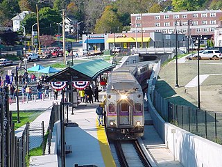
JFK/UMass station is a Massachusetts Bay Transportation Authority (MBTA) intermodal transfer station, located adjacent to the Columbia Point area of Dorchester, Boston, Massachusetts. It is served by the rapid transit Red Line; the Greenbush Line, Kingston/Plymouth Line, and Middleborough/Lakeville Line of the MBTA Commuter Rail system, and three MBTA bus routes. The station is named for the John F. Kennedy Presidential Library and Museum and the University of Massachusetts Boston, both located nearby on Columbia Point.

The MBTA Commuter Rail system serves as the commuter rail arm of the Massachusetts Bay Transportation Authority's (MBTA's) transportation coverage of Greater Boston in the United States. Trains run over 394 mi (634 km) of track to 134 stations. It is operated under contract by Keolis, which took over operations on July 1, 2014, from the Massachusetts Bay Commuter Railroad Company (MBCR).

The Old Colony Railroad (OC) was a major railroad system, mainly covering southeastern Massachusetts and parts of Rhode Island, which operated from 1845 to 1893. Old Colony trains ran from Boston to points such as Plymouth, Fall River, New Bedford, Newport, Providence, Fitchburg, Lowell and Cape Cod. For many years the Old Colony Railroad Company also operated steamboat and ferry lines, including those of the Fall River Line with express train service from Boston to its wharf in Fall River where passengers boarded luxury liners to New York City. The company also briefly operated a railroad line on Martha's Vineyard, as well as the freight-only Union Freight Railroad in Boston. The OC was named after the "Old Colony", the nickname for the Plymouth Colony.

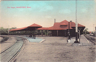
Braintree station is an intermodal transit station in Braintree, Massachusetts. It serves the MBTA's Red Line and the MBTA Commuter Rail Old Colony Lines as well as MBTA buses.

Quincy Center station is an intermodal transit station in Quincy, Massachusetts. It is a transfer station between the MBTA Red Line subway, MBTA Commuter Rail's Old Colony Lines and Greenbush Line, and a number of MBTA bus routes. It is located between Hancock Street and Burgin Parkway in the Quincy Center district. Opened in 1971, the station was covered by a large parking garage which was closed in 2012 due to structural problems and removed several years later. The station is accessible on all modes.

Wollaston station is a rapid transit station in Quincy, Massachusetts. Located in the Wollaston neighborhood, it serves the MBTA's Red Line. It was opened in September 1971 as the second of three stations in the original South Shore Extension, replacing a mainline rail station which had been located there from 1845 to 1959. Wollaston station was closed from January 8, 2018, to August 16, 2019, for renovations to the station, including flood mitigation and accessibility improvements.

The Greenbush Line is a branch of the MBTA Commuter Rail system which serves the South Shore region of Massachusetts. The 27.6-mile (44.4 km) line runs from downtown Boston, Massachusetts through the cities and towns of Quincy, Braintree, Weymouth, Hingham, Cohasset, and Scituate to the Greenbush neighborhood in southern Scituate. There are ten stations along the line. From South Station, to Quincy Center, service operates in conjunction with the Old Colony Lines commuter rail service via the Old Colony Main Line. From Weymouth Landing/East Braintree to Greenbush, trains utilize the Greenbush Branch, the former South Shore Railroad line that was later incorporated into the Old Colony Railroad.

The Old Colony Lines are a pair of branches of the MBTA Commuter Rail system, connecting downtown Boston, Massachusetts with the South Shore and cranberry-farming country to the south and southeast. The two branches operate concurrently for 10 miles (16 km) via the Old Colony Mainline from South Station to Braintree station. The Middleborough/Lakeville Line then winds south through Holbrook, Brockton, Bridgewater, Middleborough, and Lakeville via the Middleborough Main Line and Cape Main Line. The Kingston Line heads southeast to serve Weymouth, Abington, Whitman, Hanson, Halifax, and Kingston by way of the Plymouth branch. Limited service to Plymouth was provided prior to April 2021 but was cut due to low ridership and budget constraints. The Greenbush Line, which was also part of the Old Colony Division, was reactivated in 2007 as a separate project.

Hyde Park station is an MBTA Commuter Rail station in Boston, Massachusetts. It primarily serves the Providence/Stoughton Line, and also serves some weekday outbound Franklin/Foxboro Line trains. It is located on the Northeast Corridor in the Hyde Park neighborhood.

Norwood Depot is an MBTA Commuter Rail Franklin/Foxboro Line station located in downtown Norwood, Massachusetts. The station has two side platforms serving the two tracks of the Franklin Branch, each with a mini-high section for accessibility. The Norfolk County Railroad opened through South Dedham in 1849, with a station at the modern location. It was renamed Norwood in 1872. The line came under control of the New York, New Haven and Hartford Railroad in 1895. The Massachusetts Bay Transportation Authority (MBTA) began subsidizing service in 1966 and purchased the line in 1973. Under the MBTA, renovations to the station were made around 1977 and 1992.
Weymouth Landing/East Braintree station is an MBTA Commuter Rail station on the border of Braintree and Weymouth, Massachusetts. It serves the Greenbush Line. It is located in Weymouth Landing, and consists of a single side platform serving the line's one track. The station is fully accessible.

West Hingham station is an MBTA Commuter Rail station in Hingham, Massachusetts. It serves the Greenbush Line. It consists of a single side platform serving the line's one track. The station is fully accessible.

Nantasket Junction station is an MBTA Commuter Rail station in Hingham, Massachusetts. It serves the Greenbush Line. It is located off Chief Justice Cushing Highway east of downtown Hingham. It consists of a single side platform serving the line's one track. The station is fully accessible.
North Scituate station is an MBTA Commuter Rail station in Scituate, Massachusetts. It serves the Greenbush Line. The station, located at 777 Country Way in North Scituate village, is the primary station for Scituate, while nearby Greenbush station primarily serves as a park-and-ride for adjacent communities. Like the other stations on the Greenbush Line, North Scituate consists of a single full-length high-level platform which provides accessible boarding to the line's single track.

Cohasset station is an MBTA Commuter Rail station in Cohasset, Massachusetts. It serves the Greenbush Line. It is located off Chief Justice Cushing Highway west of downtown Cohasset. The station was opened with the line on October 31, 2007, providing the first rail service to Cohasset since 1959. Cohasset station is fully accessible.

Greenbush station is an MBTA Commuter Rail station in Scituate, Massachusetts. Located in the Greenbush section of Scituate, it is the terminus of the Greenbush Line.

Roslindale Village station is an MBTA Commuter Rail station on the Needham Line, located in the Roslindale Square business district of the Roslindale neighborhood in Boston, Massachusetts. The station has a single side platform serving the line's single track, with a mini-high platform for accessibility.

Windsor Gardens station is a Massachusetts Bay Transportation Authority (MBTA) Franklin/Foxboro Line station in southern Norwood, Massachusetts. The station has a single side platform serving a single track; it is not accessible. The only entrance to the station is from an adjacent apartment complex; use of the station is not restricted to residents of the complex, though there is no public parking.
The South Shore Railroad was a railroad in Massachusetts. It was incorporated in 1846 to provide rail service between Quincy and Duxbury, Massachusetts through the towns of Hingham, Cohasset, Scituate and Marshfield.

Mount Hope station was a railroad station on the Northeast Corridor in Roslindale, Boston, Massachusetts. The station consisted of two separate depots on opposite sides of the tracks. The brick outbound depot was located just north of the Blakemore Street bridge, while the wooden inbound depot was located south of the overpass.


