East Zorra-Tavistock

Last updated

East Zorra-Tavistock
Township of East Zorra-Tavistock
Tavistock and District Recreation Centre - Tavistock, ON.jpg
Canada Southern Ontario location map 2.png
Red pog.svg
East Zorra-Tavistock
Coordinates: 43°14′N80°47′W / 43.233°N 80.783°W / 43.233; -80.783
Country Flag of Canada (Pantone).svg  Canada
Province Flag of Ontario.svg  Ontario
County Oxford
Formed1 January 1975
Government
  MayorPhilip Schaefer
  Federal riding Oxford
  Prov. riding Oxford
Area
[1]
  Land242.30 km2 (93.55 sq mi)
Population
 (2016) [1]
  Total7,129
  Density29.4/km2 (76/sq mi)
Time zone UTC-5 (Eastern Standard Time (EST))
  Summer (DST) UTC-4 (Eastern Daylight Time (EDT))
Postal Code FSA
N0J
Area code(s) 519, 226, 548
Website www.ezt.ca

East Zorra-Tavistock is a township in southwestern Ontario, Canada, formed on 1 January 1975 through the amalgamation of the Township of East Zorra and the Village of Tavistock. It is part of Oxford County. The township had a population of 7,129 in the Canada 2016 Census. [1]

Contents

Communities

The township includes the population centres of Braemar, Cassel, East Zorra, Hickson, Huntingford, Innerkip, Perry Mine, Perrys Lane, Strathallan, Tavistock, Tollgate, Willow Lake, and Woodstock Airport. It also includes a portion of the hamlet of Punkeydoodles Corners, which straddles the municipal boundaries of East Zorra – Tavistock, Wilmot and Perth East.

Braemar

By 1869, Braemar was a village with a population of 75 in the Township of East Zorra, County Oxford. The average price of land was $25. [2]

Hickson

Hickson is located at the intersection of Highway 59 and County Road 8, approximately 13 kilometres (8.1 mi) north of Woodstock and 10 kilometres (6.2 mi) south of Tavistock.

Hickson was founded in 1876 when the town of Strathallen was bypassed by the new Port Dover and Lake Huron Railway, which went in east of the anticipated location. A new village was created at the whistle-stop, and Strathallan slowly faded away as community members relocated, along with a few houses moved by the milk factory. The new village was named after Sir Joseph Hickson, the general manager of the Grand Trunk Railway, who never saw the village in his lifetime. Curiously, the Hickson Centennial was celebrated erroneously in 1978 on unreliable information.

In 1932, amid the Great Depression, the Canadian National Railways (CN, the successor to the Grand Trunk) ended rail service and infrastructure maintenance on the line between Hickson and Tavistock Junction. [3] This made Hickson the northern terminus of the line, which became known as the Hickson Subdivision. By the mid-1960s, CN had successfully applied to abandon the line to Hickson as well. [4] The right of way from Woodstock to Hickson more recently has been used for the Hickson Trail. [5]

Hickson has recently added a 4th street (2014) in addition to Highway 59, which is also known as Harwood Street: Lovey's Street (County Road 8), John Street, King Crescent & Borden Court. Hickson is home to Hickson Central Public School (elementary), a public park, the East-Zorra Tavistock township hall and volunteer fire department, a post office, and several small businesses.

Huntingford

Huntingford is on Hwy 59, between Oxford Road 33 and Braemar Sideroad.

Innerkip

The village of Innerkip is located approximately 10 kilometres North-East of Woodstock. Innerkip is home to Innerkip Central Public School (elementary), Woodstock Trinity Private School, the Innerkip Highlands Golf Course, a public park, a community centre and library, a volunteer fire department, a post office, and several small businesses.

Innerkip Quarry, a recreational-nature facility is located near the community. From 1928 until its flooding in 1937, Innerkip Quarry produced gravel for railway beds. It was purchased in 1957 and since then has been used as a camp ground and trailer park. It is also used for SCUBA diving and swimming. [6] The quarry is known for diving although it has only a maximum depth of 30 feet, and the only access is by shore. There are submerged cars, boats and planes for divers to use. Ice diving is popular at the quarry in the winter time. Many companies in Southern Ontario use the quarry for training. There is no diveshop on site, but there is a tank fill station.

Tavistock

Tavistock is located 15 kilometers southeast of Stratford and five kilometers south of Shakespeare on County Road 59. The area of the village is 2.25 km²

Tavistock is home to the Tavistock Braves, a junior hockey team that plays in the Provincial Junior Hockey League, and the Tavistock Royals, a senior hockey team that plays in the Western Ontario Athletic Association Senior Hockey League.

Tavistock has hosted the World Crokinole Championship (WCC) tournament annually on the first Saturday of June since 1999. Tavistock was chosen as the host village because it was closest to the Sebastopol, Ontario home of Eckhardt Wettlaufer, the maker of the earliest known board. [7]

Government

The township is governed by a Mayor (Don McKay acclaimed at November 2006 election, [8] a Deputy Mayor (Maureen Ralph), and 5 Councillors over three geographic wards:

Demographics

In the 2021 Census of Population conducted by Statistics Canada, East Zorra-Tavistock had a population of 7,841 living in 2,976 of its 3,055 total private dwellings, a change of

Population trend: [10]

Education

Public education in the township is managed by the Thames Valley District School Board, which has the following schools in East Zorra - Tavistock. All are elementary schools (up to grade 8), after which students are bused to schools in Woodstock.

Historical schools

Libraries

Oxford County Library operates two branches within East Zorra-Tavistock: in Innerkip at 695566 Oxford Road 5 (17th line), and in Tavistock at 40 Woodstock Street South.

Natural areas and parks

Innerkip Lions Park

104 blandford st or 695566 county road 5 (17th line) , Innerkip ON. 6.9 ha (17 acres).

Optimist Club of Tavistock Park

250 Oxford Road 59, Tavistock. 4.5 ha (11 acres)

Tavistock Queen's Park

Maria St. Established in 1928. The stone gates were funded by the local Women's Institute. 20.5 ha (50 acres) of parkland and facilities.

W. Leslie Dickson Arboretum

715570 Oxford Road 4. Dedicated to the memory of W.L. Dickson. This little 6 ha (15-acre) jewel is a product of a group called "The Men of the Trees". They have worked very hard to provide in excess of 150 labeled native trees and shrubs.

Plaques and monuments

Canada's Birthday

986044 Perth-Oxford Rd. Plaque - located at Punkeydoodle's Corners. a 6-sided concrete pillar with the inscription "Canada's Birthday 1982". It commemorates the Rt. Honourable Joe Clark's visit to the community on this day.

David Stock, Caister's Tavern

597112 Oxford Road 59, Tavistock. Caister's Tavern c. 1845–1854. Caleb Caister came from England to Oxford County in 1833. In 1836, he settled on this site, cleared farmland and built a one-storey log dwelling. This dwelling was his family home but also served as an inn and tavern. Until 1848, when what is now Tavistock was established, Caister's home was the only public accommodation in north-central Oxford County for pioneers moving along the Huron Road and thence southerly into the Zorra settlement. By the 1840s, Caister held an official municipal licence, and a survey map of the time shows that his log dwelling was known in this locality as Caister's Tavern.

Founder of Tavistock

22 Woodstock St. S, Tavistock. A stone cairn erected 1930 in memory of Captain Henry Eckstein, founder of Tavistock, A.D. 1848. Rededicated 1948. Rebuilt and rededicated in 1998.

A Tribute to Farm Women

OMAFRA site - Outdoor Farm show. This monument represents the role of farm women in the foundation and progress of Canadian Agriculture. Women from across the nation brought stones from their farms to help build this structure, erected throughout the three days of Canada's Outdoor Farm Show, September 2000. Presented by Farm Credit Corporation, Canada's Outdoor Farm Show, Ontario Farm Women's Network.

The Glass Swan

An historic house from Tavistock's earliest days, at 52 Woodstock St. S. There is a plaque marking its significance.

See also

Related Research Articles

<span class="mw-page-title-main">Caledon, Ontario</span> Town in Ontario, Canada

Caledon is a town in the Regional Municipality of Peel in the Greater Toronto Area of Ontario, Canada. The name comes from a shortened form of Caledonia, the Roman name for North Britain. Caledon is a developing urban area, but it remains primarily rural. It consists of an amalgamation of a number of urban areas, villages, and hamlets. Its major urban centre is Bolton, on its eastern side, adjacent to York Region.

<span class="mw-page-title-main">Woodstock, Ontario</span> City in Ontario, Canada

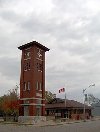
Woodstock is a city in Southwestern Ontario, Canada. The city has a population of 40,902 according to the 2016 Canadian census. Woodstock is the seat of Oxford County, at the head of the non-navigable Thames River, approximately 128 km from Toronto, and 43 km from London, Ontario. The city is known as the Dairy Capital of Canada and promotes itself as "The Friendly City".

<span class="mw-page-title-main">Selwyn, Ontario</span> Township in Ontario, Canada

Selwyn is a township in central-eastern Ontario, Canada, located in Peterborough County.

<span class="mw-page-title-main">Essa, Ontario</span> Township in Ontario, Canada

Essa is a township in Ontario, Canada, west and south of the city of Barrie in Simcoe County. It is bounded by County Road 90 to its north, County Road 27 to its east, and Ontario Highway 89 to its south. The township is about 100 kilometres (62 mi) from Toronto. The township is well known for its agriculture industry, particularly potato farming. Nearby CFB Borden brings a strong military presence to the area as well, including a high number of Francophone families.

<span class="mw-page-title-main">Wilmot, Ontario</span> Township in Ontario, Canada

The Township of Wilmot is a rural township in the Regional Municipality of Waterloo in southwestern Ontario, Canada.

<span class="mw-page-title-main">Havelock-Belmont-Methuen</span> Township in Ontario, Canada

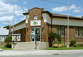
Havelock-Belmont-Methuen is a township in central-eastern Ontario, Canada, in Peterborough County. On January 1, 1998, Belmont and Methuen Township amalgamated with the Village of Havelock to form what is now Havelock-Belmont-Methuen.

<span class="mw-page-title-main">Douro-Dummer</span> Township in Ontario, Canada

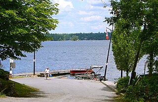
Douro-Dummer is a township in central-eastern Ontario, Canada, in Peterborough County along the Trent-Severn Waterway. It was formed on January 1, 1998, through the amalgamation of Douro and Dummer Townships.

<span class="mw-page-title-main">Oxford County, Ontario</span> Regional municipality in Ontario, Canada

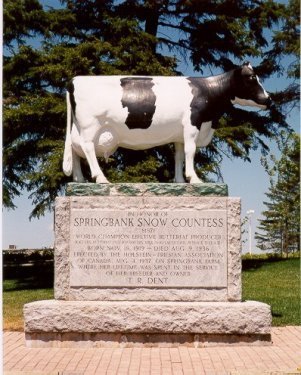
Oxford County is a regional municipality in the Canadian province of Ontario. Highway 401 runs east–west through the centre of the county, creating an urban industrial corridor with more than half the county's population, spanning 25 km between the Toyota auto assembly plant in Woodstock and the CAMI General Motors auto assembly plant in Ingersoll. The local economy is otherwise dominated by agriculture, especially the dairy industry.

<span class="mw-page-title-main">Oxford (federal electoral district)</span> Federal electoral district in Ontario, Canada

Oxford is a federal electoral district in Ontario, Canada, that has been represented in the House of Commons of Canada since the 1935 election.

Oxford North was a federal electoral district represented in the House of Commons of Canada from 1867 to 1935. It was located in the province of Ontario. It was created by the British North America Act of 1867.

<span class="mw-page-title-main">Guelph/Eramosa</span> Township in Ontario, Canada

Guelph/Eramosa is a township located in Wellington County, in midwestern Ontario, Canada. It partly encircles the city of Guelph, surrounding it in a continuous arc from approximately northeast to south-southwest of the city. It is part of the Guelph census metropolitan area.

<span class="mw-page-title-main">Zorra</span> Township in Ontario, Canada

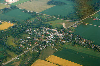
Zorra is a township in Oxford County, situated in south-western Ontario, Canada. A predominantly rural municipality, Zorra was formed in 1975 through the amalgamation of East Nissouri, West Zorra and North Oxford townships. It is best known for the Highland Games weekend held each summer in Embro, celebrating the heritage of the Scottish pioneer families which grew from the 1830s to form nearly a quarter of the county's population.

<span class="mw-page-title-main">Blandford-Blenheim</span> Township in Ontario, Canada

Blandford-Blenheim is a township in the Canadian province of Ontario, located in Oxford County. The township had a population of 7,359 in the Canada 2011 Census.

<span class="mw-page-title-main">Norwich, Ontario</span> Township in Ontario, Canada

The Township of Norwich is a municipality located in Oxford County in Southwestern Ontario, Canada. At the centre of the Township of Norwich is the Town of Norwich. The preferred pronunciation of the town name is NOR-witch, which differs from the pronunciation NORR-ij used for the city of Norwich, England. The origin of Norwich, Ontario, is more likely Norwich in upper New York State, the area from which the pioneering families emigrated in the early 19th century, where the community was known as Norwichville.

<span class="mw-page-title-main">Perth East, Ontario</span> Township in Ontario, Canada

The Township of Perth East is a municipality in Perth County, Ontario, Canada and situated north of Stratford. It was created in 1998 when the Ontario government amalgamated the village of Milverton with the surrounding former townships of Ellice, Mornington, North Easthope and South Easthope.

<span class="mw-page-title-main">Stone Mills</span> Township in Ontario, Canada

Stone Mills is a lower-tier township north of Greater Napanee in Lennox and Addington County, Ontario, Canada. According to the 2016 census, the township has a population of 7,702.

Valentine Stock was an Ontario merchant and political figure. He represented Perth South in the Legislative Assembly of Ontario from 1902 to 1904 and from 1908 to 1911 as a Liberal member.

<span class="mw-page-title-main">South-West Oxford</span> Township in Ontario, Canada

South-West Oxford is a township in the Canadian province of Ontario, located within Oxford County. The township had a population of 7,664 in the 2016 Canadian census. A predominantly rural municipality, South-West Oxford was formed in 1975 through the amalgamation of Dereham and West Oxford townships and the village of Beachville.

<span class="mw-page-title-main">Ontario Highway 59</span> Former Ontario provincial highway

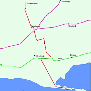
King's Highway 59, commonly referred to as Highway 59, was a provincially maintained highway in the Canadian province of Ontario. It connected Long Point Provincial Park in Norfolk County to the town of Shakespeare in Perth County, passing through the city of Woodstock in Oxford County en route. Several smaller towns also lined the highway, notably Courtland, Delhi, Norwich and Tavistock. Highway 59 featured junctions with Highway 3, Highway 2, Norfolk County Highway 24 and the concurrent routes of Highway 7 and Highway 8. Highway 59 also had an interchange with Highway 401.

Elections were held in Oxford County, Ontario on October 22, 2018 in conjunction with municipal elections across the province.

References

  1. 1 2 3 4 "East Zorra-Tavistock census profile". 2016 Census of Population . Statistics Canada. Retrieved May 21, 2019.
  2. The province of Ontario gazetteer and directory. H. McEvoy Editor and Compiler, Toronto : Robertson & Cook, Publishers, 1869
  3. "Otterville Subdivision". CNR-in-Ontario.com. Retrieved 25 April 2022.
  4. "Hickson Subdivision". CNR-in-Ontario.com. Retrieved 25 April 2022.
  5. "About the Trail". Hickson Trail. Retrieved 25 April 2022.
  6. Geo Diving
  7. "Eckhardt Wettlaufer maker of the Oldest Known Crokinole Board". World Crokinole Championship. Retrieved May 21, 2019.
  8. "Elections 2006". Township of East Zorra-Tavistock. Archived from the original on April 15, 2012.
  9. "Population and dwelling counts: Canada, provinces and territories, census divisions and census subdivisions (municipalities), Ontario". Statistics Canada. February 9, 2022. Retrieved April 2, 2022.
  10. Statistics Canada: 1996, 2001, 2006, 2011 census