
Northwood is an area in the London Borough of Hillingdon, North West London, located 14.5 miles (23.3 km) north-west of Charing Cross. Northwood was part of the ancient parish of Ruislip, Middlesex. The area was situated on the historic Middlesex boundary with Hertfordshire, and since being incorporated into Greater London in 1965, has been on the Greater London boundary with that county.

Ruislip is a suburb in the London Borough of Hillingdon in West London. Prior to 1965 it was in Middlesex. Ruislip lies 13.8 miles (22.2 km) west-north-west of Charing Cross, London.

The London Borough of Hillingdon is the largest and westernmost borough in West London, England. It was formed in 1965 from the districts of Hayes and Harlington, Ruislip-Northwood, Uxbridge, and Yiewsley and West Drayton in the ceremonial county of Middlesex. Today, Hillingdon is home to Heathrow Airport and Brunel University, and is the second largest of the 32 London boroughs by area.

Glastonbury is a town in the Capitol Planning Region, Connecticut, United States, formally founded in 1693 and first settled in 1636. It was named after Glastonbury in Somerset, England. Glastonbury is on the banks of the Connecticut River, 7 miles (11 km) southeast of Hartford. The town center is defined by the U.S. Census Bureau as a census-designated place (CDP). The population was 35,159 at the 2020 census.

The North York Moors is an upland area in north-eastern Yorkshire, England. It contains one of the largest expanses of heather moorland in the United Kingdom. The area was designated as a National Park in 1952, through the National Parks and Access to the Countryside Act 1949. Covering an area of 554 sq mi (1,430 km2), the National Park has a population of 23,380. It is administered by the North York Moors National Park Authority, which is based in Helmsley.
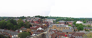
Rickmansworth, a town in south-west Hertfordshire, England, is located approximatly 17 miles (27 km) north-west of central London, 5 miles (8 km) south-west of Watford and inside the perimeter of the M25 motorway. The town is mainly to the north of the Grand Union Canal and the River Colne.

Moor Park is a London Underground station in the Three Rivers district of Hertfordshire, serving those living on the Moor Park estate, and also on the neighbouring Eastbury and South Oxhey estates. The station is outside the Greater London boundary but is in both Zone 6 and Zone 7, between the Metropolitan line stations of Rickmansworth, Croxley and Northwood.

South West Hertfordshire is a constituency in the House of Commons of the UK Parliament, represented since 2019 by Gagan Mohindra, a Conservative.
Moor Park is a private residential estate in the Three Rivers District of Hertfordshire, England. Located approximately 16 miles (26 km) northwest of central London and adjacent to the Greater London boundary.
Moor Park may refer to several things in England:

Northwood Headquarters is a military headquarters facility of the British Armed Forces in Eastbury, Hertfordshire, England, adjacent to the London suburb of Northwood. It is home to the following military command and control functions:
- Headquarters, Strategic Command, formerly Joint Forces Command
- Permanent Joint Headquarters
- Commander Operations for the Royal Navy
- NATO Allied Maritime Command
Greenfield is a small village about 2 km (1.2 mi) from the town of Flitwick in Bedfordshire, England. It lies across Flitwick Moor from the larger settlement of Flitwick and is on the opposite side of the River Flit. It forms part of the parish of Flitton and Greenfield.

Lealholm is a small village in the Glaisdale civil parish of the Borough of Scarborough, in North Yorkshire, England. It is sited at a crossing point of the River Esk, in Eskdale which is within the North York Moors National Park. It is 9.5 miles (15.3 km) by road from the nearest town of Whitby, and approximately 27 miles (43 km) from both Middlesbrough and Scarborough. The village is typical of those found all across the North York Moors which straddle the main through-routes along the valley bottoms. It is mostly built of local stone with pantiled or slate roofs.

The geography of Greater Manchester is dominated by one of the United Kingdom's largest metropolitan areas, and in this capacity the landlocked metropolitan county constitutes one of the most urbanised and densely populated areas of the country. There is a mix of high density urban areas, suburbs, semi-rural and rural locations in Greater Manchester, but overwhelmingly the land use in the county is urban.

Northwood is a community encompassing the northern portions of the city of Irvine, in Orange County, California. It covers the area enclosed by the Santa Ana Freeway, Culver Drive, Portola Parkway and Jeffrey Road.

Eastbury is a village in the valley of the River Lambourn in the English county of Berkshire. The village is situated on the old river level road from Newbury to Lambourn, and is 1.5 miles (2.4 km) east of Lambourn and 1 mile (1.6 km) west of East Garston. The village is situated in the civil parish of Lambourn, which is within the unitary authority of West Berkshire.

Moor Park and Eastbury is a ward in Three Rivers, in England. It is located in south-west Hertfordshire, in the East of England region. The ward includes the eponymous twin settlements of Moor Park and Eastbury, lying between Rickmansworth to the west, Croxley Green to the north, South Oxhey to the east, and Northwood to the south.
This page provides brief details of primary schools in the borough of Three Rivers in Hertfordshire, England, United Kingdom.
The More was a 16th-century palace in the parish of Rickmansworth, Hertfordshire, England, where Catherine of Aragon lived after the annulment of her marriage to Henry VIII. It had been owned by Cardinal Wolsey. It lay at the northeast corner of the later More Park estate on the edge of the Colne flood plain. The Treaty of the More was celebrated here by Henry VIII and the French ambassadors. In 1527, the French ambassador, Jean du Bellay, thought the house more splendid than Hampton Court. Nothing now remains above ground. The site is a scheduled ancient monument. In the grounds of the school exist parts of at least two large stone pillars approximately one metre in length which are said to be part of the original manor.
