
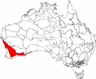
Eastern Mallee is an Interim Biogeographic Regionalisation for Australia (IBRA) subregion in southern Western Australia.
Eastern Mallee is an Interim Biogeographic Regionalisation for Australia (IBRA) subregion in southern Western Australia.
Eastern Mallee is roughly defined as the eastern half of the Mallee biogeographic region. It has an area of around 46,000 square kilometres, and is very sparsely populated. The only towns occur along the road from Esperance to Norseman. The largest and best known town is Salmon Gums; others include Scaddan, Grass Patch, Red Lake and Dowak, Western Australia.
Watercourses in the area include Young River, Lort River, Oldfield River and Jerdacuttup River. Drainage is occluded, however, and the area has numerous salt pans. [1]

Situated on the south-eastern edge of the Yilgarn Craton, Eastern Mallee has a gently undulating landscape. It has a variety of surface types, including calcareous clays and loams containing kankar; outcrops of metamorphosed sandstone; white and yellow sand; and loamy pan fields. Gypsum dunes also occur in the area. [1]
Western Mallee is semi-arid, with a warm, dry, Mediterranean climate, and a winter rainfall of 300 and 500 millimetres (12–19 in). [1]
| Jan | Feb | Mar | Apr | May | Jun | Jul | Aug | Sep | Oct | Nov | Dec | Year | ||
|---|---|---|---|---|---|---|---|---|---|---|---|---|---|---|
| Mean daily maximum temperature | 30.5 °C 86.9 °F | 29.5 °C 85.1 °F | 27.2 °C 81.0 °F | 23.5 °C 74.3 °F | 19.6 °C 67.3 °F | 16.8 °C 62.2 °F | 16.0 °C 60.8 °F | 17.2 °C 63.0 °F | 20.4 °C 68.7 °F | 23.2 °C 73.8 °F | 26.1 °C 79.0 °F | 28.9 °C 84.0 °F | 23.2 °C 73.8 °F | |
| Mean daily minimum temperature | 14.0 °C 57.2 °F | 14.2 °C 57.6 °F | 12.7 °C 54.9 °F | 10.0 °C 50.0 °F | 7.2 °C 45.0 °F | 5.6 °C 42.1 °F | 4.6 °C 40.3 °F | 4.7 °C 40.5 °F | 5.8 °C 42.4 °F | 7.5 °C 45.5 °F | 10.1 °C 50.2 °F | 12.3 °C 54.1 °F | 9.0 °C 48.2 °F | |
| Mean total rainfall | 19.3 mm 0.7 in | 23.4 mm 0.9 in | 23.1 mm 0.9 in | 26.0 mm 1.0 in | 35.1 mm 1.4 in | 40.9 mm 1.6 in | 36.7 mm 1.4 in | 33.9 mm 1.3 in | 31.5 mm 1.2 in | 26.8 mm 1.0 in | 25.8 mm 1.0 in | 19.3 mm 0.7 in | 341.9 mm 13.2 in | |
| Mean number of rain days | 3.9 | 4.1 | 4.9 | 7.1 | 9.4 | 10.8 | 11.9 | 11.5 | 9.7 | 7.7 | 5.7 | 4.2 | 90.9 | |
| Source: Bureau of Meteorology [2] | ||||||||||||||

Only about 34% of the subregion retains its native vegetation. Within this area, most soil types carry mallee communities consisting primarily of Eucalyptus species. Clay soils support patches of Eucalyptus woodland in addition to mallee, and calcareous clay areas are vegetated by communities of mallee with Melaleuca pauperiflora (Boree). Myrtaceous and proteaceous scrub-heath occurs in sandstone areas, and salt affected areas grow Tecticornia (Samphire). [1]
There are also a number of vegetation communities of lesser extent, including some that are considered endangered or at risk. These include vulnerable thicket communities of the Russell Range, and a vulnerable ecological community of herb and bunch grasslands that occurs on gypsum dunes along the margins of salt lakes. Granite outcrops also have their own characteristic vegetation. [1]
Information on Eastern Mallee's flora and fauna is scarce, as the area has not had a thorough biodiversity survey. What information is available has been gathered in the context of conservation assessment:
The subregion contains many endemic plant species in the Eucalyptus and Acacia genera. It contains numerous rare, endangered and priority flora. Declared rare flora include Adenanthos eyrei (Toolinna adenanthos), Anigozanthos bicolor subsp. minor, Conostylis lepidospermoides (sedge conostylis), Drummondita longifolia , Eremophila denticulata subsp. denticulata (toothed eremophila), Eremophila lactea , Eucalyptus merrickiae , Leucopogon marginatus , Myoporum turbinatum and Ricinocarpos trichophorus . [1]
It also supports a number of rare or endangered fauna, including the mammals western quoll (Dasyurus geoffroii) and dibbler (Parantechinus apicalis); the birds short-billed black-cockatoo (Calyptorhynchus latirostris), slender-billed thornbill (Acanthiza iredalei iredalei), malleefowl (Leipoa ocellata), western whipbird (Psophodes nigrogularis), crested shrike-tit (Falcunculus frontatus) and hooded plover (Charadrius rubricollis); and the carpet python (Morelia spilota). Coastal areas are also visited by the shy albatross (Thalassarche cauta), the Australian sea lion (Neophoca cinerea) and the southern right whale (Eubalaena australis). [1]
Around a quarter of Eastern Mallee falls within what the Department of Agriculture and Food terms the "Intensive Land-use Zone" (ILZ), the area of Western Australia that has been largely cleared and developed for intensive agriculture such as cropping and livestock production. The remaining three quarters of the subregion falls within the "Extensive Land-use Zone" (ELZ), where the native vegetation has not been cleared but may have been degraded by the grazing of introduced animals and/or changes to the fire regime. In total, around 70% of Eastern Mallee retains its native vegetation. [3]
Somewhat less than 15% of the subregion is held within nature reserves, [1] covering about 34% of the remaining native vegetation. [3] Prominent nature reserves include Frank Hann National Park, Peak Charles National Park and Cape Arid National Park. There is also substantial mining in the area, with large areas covered by mines, mining tenements or exploration leases. There is also a small amount of gypsum mining in the area, and some plantation forestry. [1]
Little is done to manage the subregion for conservation purposes, as most reserves are relatively undisturbed giving it a low management priority. Rising salinity is a threat in cleared areas, and this is completely unmanaged. The threat of bushfire is managed by the maintenance of firebreaks and fire access tracks. There is no management of feral rabbits and foxes, and incursions of agricultural weeds. [1]
The subregion was given a Continental Stress Class of 4 when measured against the criteria, but the authors of that assessment stated that it should more properly be rated at 3, because of the threat of salinity, and because clearance of western parts has resulted in a biased reserve system. [1]
Eastern Mallee was introduced in IBRA Version 6.1. Its region code is MAL1. It is one of two subregions of the Mallee region, the other being Western Mallee. [4] The Mallee, Avon Wheatbelt and Geraldton Sandplains regions together comprise Hopper's Transitional Rainfall Zone of Beard's South West Botanical Province. [5] [6] Under the World Wide Fund for Nature's regionalisation of the world's terrestrial surface into "ecoregions", the Western Mallee subregion falls within the Esperance Mallee ecoregion, one of 6 ecoregions comprising the Southwest Australia ecozone.

The Carnarvon xeric shrublands is a deserts and xeric shrublands ecoregion of Western Australia. The ecoregion is coterminous with the Carnarvon Interim Biogeographic Regionalisation for Australia (IBRA) bioregion.

The Interim Biogeographic Regionalisation for Australia (IBRA) is a biogeographic regionalisation of Australia developed by the Australian government's Department of Sustainability, Environment, Water, Population, and Communities. It was developed for use as a planning tool, for example for the establishment of a national reserve system. The first version of IBRA was developed in 1993–94 and published in 1995.

Southwest Australia is a biogeographic region in Western Australia. It includes the Mediterranean-climate area of southwestern Australia, which is home to a diverse and distinctive flora and fauna.

Esperance Plains, also known as Eyre Botanical District, is a biogeographic region in southern Western Australia on the south coast between the Avon Wheatbelt and Hampton bioregions, and bordered to the north by the Mallee region. It is a plain punctuated by granite and quartz outcrops and ranges, with a semi-arid Mediterranean climate and vegetation consisting mostly of mallee-heath and proteaceous scrub. About half of the region has been cleared for intensive agriculture. Recognised as a bioregion under the Interim Biogeographic Regionalisation for Australia (IBRA), it was first defined by John Stanley Beard in 1980.

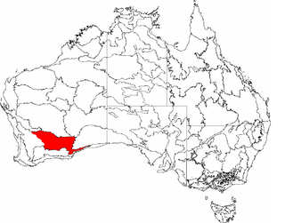
Mallee, also known as Roe Botanical District, is a biogeographic region in southern Western Australia. Located between the Esperance Plains, Avon Wheatbelt and Coolgardie bioregions, it has a low, gently undulating topography, a semi-arid mediterranean climate, and extensive Eucalyptus mallee vegetation. It has an area of 73,975.59 square kilometres (28,562.13 sq mi). About half of the region has been cleared for intensive agriculture. Recognised as a region under the Interim Biogeographic Regionalisation for Australia (IBRA), it was first defined by John Stanley Beard in 1980.

Warren, also known as Karri Forest Region and the Jarrah-Karri forest and shrublands ecoregion, is a biogeographic region in southern Western Australia. Located in the southwest corner of Western Australia between Cape Naturaliste and Albany, it is bordered to the north and east by the Jarrah Forest region. Its defining characteristic is an extensive tall forest of Eucalyptus diversicolor (karri). This occurs on dissected, hilly ground, with a moderately wet climate. Karri is a valuable timber and much of the karri forest has been logged over, but less than a third has been cleared for agriculture. Recognised as a region under the Interim Biogeographic Regionalisation for Australia (IBRA), and as a terrestrial ecoregion by the World Wide Fund for Nature, it was first defined by Ludwig Diels in 1906.

Esperance mallee is an ecoregion on the south coast of Western Australia, a coastal strip where the predominant vegetation consists of short eucalyptus trees and shrubs.
The Transitional Rainfall Zone (TRZ) is one of three biogeographic zones into which south-west Western Australia is divided, the others being the High Rainfall Zone and the Low Rainfall Zone. The TRZ is recognised as having a much higher diversity of rare and endemic plant species than the other Zones.
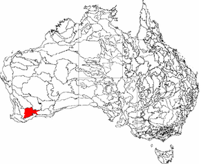
Western Mallee is an Interim Biogeographic Regionalisation for Australia (IBRA) subregion in southern Western Australia. It is a sparsely populated subregion with an area of about 47,000 square kilometres, roughly centred on the town of Newdegate. Largely cleared for intensive agriculture, it still retains patches of native vegetation, but these are under environmental stress from threats such as rising salinity, and are poorly managed.
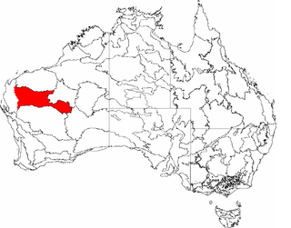
Coolgardie is an Australian bioregion consisting of an area of low hills and plains of infertile sandy soil in Western Australia. It has an area of 129,122.09 square kilometres (49,854.32 sq mi). It includes much of the Great Western Woodlands.
Gascoyne is an interim Australian bioregion located in Western Australia. It has an area of 180,752.57 square kilometres (69,788.96 sq mi).. Together with Murchison bioregion to the south, it constitutes the Western Australian Mulga shrublands ecoregion, as assessed by the World Wildlife Fund.

Hampton is an interim Australian bioregion located in southeastern coastal Western Australia, with a small portion (4%) extending into adjacent South Australia. It has an area of 1,088,198 hectares. The Hampton bioregion is part of the Coolgardie woodlands ecoregion.

The Brigalow Belt is a wide band of acacia-wooded grassland that runs between tropical rainforest of the coast and the semi-arid interior of Queensland, Australia. The Interim Biogeographic Regionalisation for Australia (IBRA) divides the Brigalow Belt into two IBRA regions, or bioregions, Brigalow Belt North (BBN) and Brigalow Belt South (BBS). The North and South Brigalow Belt are two of the 85 bioregions across Australia and the 15 bioregions in Queensland. Together they form most of the Brigalow tropical savanna ecoregion.

The Eyre Yorke Block, also known as the Eyre and Yorke mallee, is an interim Australian bioregion and a World Wildlife Fund ecoregion covering part of the Eyre Peninsula and all of Yorke Peninsula as well as land to its immediate east in South Australia.

The Yathong Nature Reserve is a protected nature reserve that is also a nationally and internationally recognized biosphere situated in the central-western region of New South Wales, in eastern Australia. The 107,240-hectare (265,000-acre) reserve was listed by UNESCO in 1977 as a Biosphere Reserve under the Man and the Biosphere Programme (MAB). The reserve is significant for its biodiversity in both native plant and animal species. Cultural heritage and historical grazing activities add to the significance of this site as a conservation area.

The Cape York Peninsula tropical savanna is a tropical grasslands, savannas, and shrublands ecoregion in northern Australia. It occupies the Cape York Peninsula in Queensland, mainland Australia's northernmost point. It is coterminous with the Cape York Peninsula, an interim Australian bioregion.

Tanami is an interim Australian bioregion, comprising 25,997,277 hectares in the Northern Territory and Western Australia. It is part of the Great Sandy-Tanami desert ecoregion.

Gawler is an interim Australian bioregion located in South Australia. It has an area of 12,002,883 hectares. Gawler bioregion is part of the Tirari–Sturt stony desert ecoregion.
{{cite journal}}: Cite journal requires |journal= (help)CS1 maint: multiple names: authors list (link)