
Kiribati consists of 32 atolls and one island scattered over all four hemispheres in an expanse of ocean equivalent in size to the continental United States. The islands lie roughly halfway between Hawaii and Australia in the Micronesian and Polynesian regions of the South Pacific. The three main island groupings are the Gilbert Islands, Phoenix Islands, and Line Islands. On 1 January 1995 Kiribati moved the International Date Line to include its easternmost islands and make it the same day throughout the country.

The Marshall Islands consist of two archipelagic island chains of 30 atolls and 1,152 islands, which form two parallel groups—the "Ratak" (sunrise) chain and the "Ralik" (sunset) chain. The Marshalls are located in the North Pacific Ocean and share maritime boundaries with Micronesia and Kiribati. Two-thirds of the nation's population lives in the capital of Majuro and the settlement of Ebeye. The outer islands are sparsely populated due to lack of employment opportunities and economic development.

Micronesia is a subregion of Oceania, composed of thousands of small islands in the western Pacific Ocean. It has a close shared cultural history with three other island regions: the Philippines to the west, Polynesia to the east, and Melanesia to the south; as well as with the wider Austronesian peoples.

The Malabar Coast moist forests is a tropical moist broadleaf forest ecoregion of southwestern India.
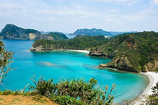
The Ogasawara subtropical moist forests is a terrestrial ecoregion which encompasses the Ogasawara Archipelago of Japan. The Ogasawara Archipelago lies in the Pacific Ocean south of Honshu, Japan's largest island, and north of the Marianas Islands. The ecoregion includes the Bonin Islands and Volcano Islands chains. The islands are volcanic in origin, and have never been linked to a continent. They are home to distinct plants and animals including many endemic species.

The Hawaiian jungles are a tropical moist broadleaf forest ecoregion in the Hawaiian Islands. They cover an area of 6,700 km2 (2,600 sq mi) in the windward lowlands and montane regions of the islands. Coastal mesic forests are found at elevations from sea level to 300 m (980 ft). Mixed mesic forests occur at elevations of 750 to 1,250 m, while wet forests are found from 1,250 to 1,700 m. Moist bogs and shrublands exist on montane plateaus and depressions. For the 28 million years of existence of the Hawaiian Islands, they have been isolated from the rest of the world by vast stretches of the Pacific Ocean, and this isolation has resulted in the evolution of an incredible diversity of endemic species, including fungi, mosses, snails, birds, and other wildlife. In the lush, moist forests high in the mountains, trees are draped with vines, orchids, ferns, and mosses. This ecoregion includes one of the world's wettest places, the slopes of Mount Waiʻaleʻale, which average 373 in (9,500 mm) of rainfall per year.

The Maldives-Lakshadweep-Chagos Archipelago tropical moist forests is a tropical moist broadleaf forest ecoregion in South Asia. It spans a chain of coralline islands in the Indian Ocean, including Lakshadweep, a union territory of India; the Maldives, an independent country; and the British Indian Ocean Territory, an overseas territory of the United Kingdom.

The Tongan tropical moist forests is a tropical and subtropical moist broadleaf forests ecoregion that includes the Tonga archipelago and Niue.

The Cook Islands tropical moist forests is a tropical and subtropical moist broadleaf forests ecoregion that covers the Southern Cook Islands in the Cook Islands.

The Tubuai tropical moist forests is a tropical and subtropical moist broadleaf forests ecoregion in French Polynesia. It covers the Austral Islands.

The Society Islands tropical moist forests is a tropical and subtropical moist broadleaf forests ecoregion in the Society Islands of French Polynesia.

The Marquesas tropical moist forests is a tropical and subtropical moist broadleaf forests ecoregion in the Marquesas Islands of French Polynesia.

The Tuamotu tropical moist forests is a tropical and subtropical moist broadleaf forests ecoregion in the Tuamotu Archipelago of French Polynesia and the Pitcairn Islands.

The Central Polynesian tropical moist forests is a tropical and subtropical moist broadleaf forests ecoregion in Polynesia. It includes the northern Cook Islands, the Line Islands in Kiribati, and Johnston Atoll, Jarvis Island, Palmyra Atoll, and Kingman Reef which are possessions of the United States.

The Western Polynesian tropical moist forests is a tropical and subtropical moist broadleaf forests ecoregion in Polynesia. It includes Tuvalu, the Phoenix Islands in Kiribati, Tokelau, and Howland and Baker islands, which are possessions of the United States.
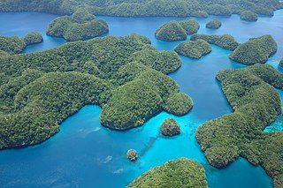
The Palau tropical moist forests is a tropical and subtropical moist broadleaf forests ecoregion in Micronesia. It encompasses the nation of Palau.
The Marianas tropical dry forests is a tropical and subtropical dry broadleaf forests ecoregion on the Marianas Islands in the western Pacific Ocean.

The Carolines tropical moist forests is a tropical and subtropical moist broadleaf forests ecoregion in Micronesia. It includes the central and eastern Caroline Islands in the Federated States of Micronesia.
The Yap tropical dry forests is a tropical and subtropical dry broadleaf forests ecoregion in Micronesia. It includes the Yap Islands and neighboring atolls in the Federated States of Micronesia.

The Northwestern Hawaii scrub is a tropical and subtropical grasslands, savannas, and shrublands ecoregion on the Northwestern Hawaiian Islands in the Pacific Ocean.

