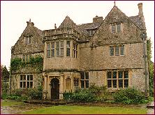
St Catherine's Court is a manor house in a secluded valley north of Bath, Somerset, England. It is a Grade I listed property. The gardens are Grade II* listed on the Register of Historic Parks and Gardens of special historic interest in England.

East Harptree is a village and civil parish in Somerset, England. It is situated 5 miles (8.0 km) north of Wells and 15 miles (24.1 km) south of Bristol, on the northern slope of the Mendip Hills overlooking the Chew Valley. The parish has a population of 644. The parish includes the hamlet of Coley.

Temple Cloud is a village in the Chew Valley in Somerset on the A37 road. It is in the civil parish of Temple Cloud with Cameley and in the council area of Bath and North East Somerset. It is 10 miles (16 km) from Bristol and 5 miles (8 km) from the town of Midsomer Norton. The villages of Cameley and Clutton are nearby.
West Harptree is a small village and civil parish in the Chew Valley, Somerset within the unitary district of Bath and North East Somerset. The parish has a population of 439.
Halswell House is a Grade I listed country house in Goathurst, Somerset, England.

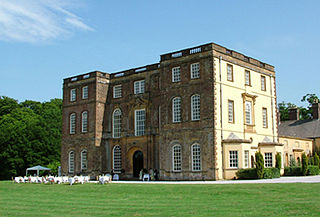
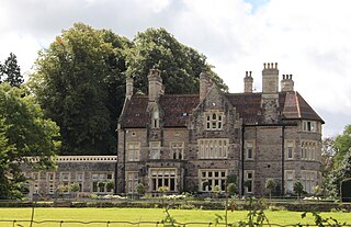
Newton Park is an 18th-century Grade I listed country house in the parish of Newton St Loe, Somerset, England, situated 4 miles (6.4 km) west of Bath.

The Grade I listed buildings in Somerset, England, demonstrate the history and diversity of its architecture. The ceremonial county of Somerset consists of a non-metropolitan county, administered by Somerset County Council, which is divided into five districts, and two unitary authorities. The districts of Somerset are West Somerset, South Somerset, Taunton Deane, Mendip and Sedgemoor. The two administratively independent unitary authorities, which were established on 1 April 1996 following the breakup of the county of Avon, are North Somerset and Bath and North East Somerset. These unitary authorities include areas that were once part of Somerset before the creation of Avon in 1974.

Bath and North East Somerset is a unitary authority created on 1 April 1996, following the abolition of the County of Avon, which had existed since 1974. Part of the ceremonial county of Somerset, Bath and North East Somerset occupies an area of 220 square miles (570 km2), two-thirds of which is green belt. It stretches from the outskirts of Bristol, south into the Mendip Hills and east to the southern Cotswold Hills and Wiltshire border. The city of Bath is the principal settlement in the district, but BANES also covers Keynsham, Midsomer Norton, Radstock and the Chew Valley. The area has a population of 170,000, about half of whom live in Bath, making it 12 times more densely populated than the rest of the area.

Cothelstone Manor in Cothelstone, Somerset, England was built in the mid-16th century, largely demolished by the parliamentary troops in 1646 and rebuilt by E.J. Esdaile in 1855–56.

Hatch Court in the parish of Hatch Beauchamp, in Somerset, England, is a grade I listed mansion built in about 1755 in the Palladian style with Bath Stone by the wool merchant John Collins to the design of Thomas Prowse. The site had been occupied since the mediaeval era by various forms of the manor house of the manor of Hatch, the caput of an important feudal barony first held by the Anglo-Norman de Beauchamp family in the 11th century.
Mells Manor at Mells, Somerset, England, was built in the 16th century for Edward Horner, altered in the 17th century, partially demolished around 1780, and restored by Sir Edwin Lutyens in the 20th century. The house, along with the garden walls, has been designated as a Grade I listed building, and is closely associated with the adjacent Church of St Andrew. The gardens are listed, Grade I, on the Register of Historic Parks and Gardens of special historic interest in England.

Earnshill House in Hambridge, near Curry Rivel, Somerset, England is a manor house, set in parkland. It was built in 1725 for Henry Combe, a Bristol merchant by John Strachan. It has been designated as a Grade I listed building.

The Church of St Margaret in Hinton Blewett, Somerset, England probably dates from the 13th century although parts are as late as the 16th or 17th century. It has been designated as a Grade I listed building.

Shockerwick House in Bathford, Somerset, England was built as a manor house around 1750 by John Wood, the Elder. It has been designated as a Grade I listed building. It is set in 7.7 hectares of parkland within the Bybrook River valley.

Kelston Park is an 18th-century country house in the village of Kelston, approximately 3 miles from Bath in North East Somerset, England. Altogether the house and gardens of Kelston Park cover an area of approximately 75 hectares. The house has been designated as a Grade II* listed building, and the garden is Grade II* listed in the National Register of Historic Parks and Gardens.

East Lambrook Manor is a small 15th-century manor house in East Lambrook, Somerset, England, registered by English Heritage as a Grade II* listed building. It is surrounded by a "cottage garden" planted by Margery Fish between 1938 and her death in 1969. The garden is Grade I listed in the Register of Historic Parks and Gardens of special historic interest in England.
Eastwood Manor is a Grade II listed building in the village of East Harptree in the English County of Somerset.
Bath and North East Somerset is a unitary authority created on 1 April 1996, following the abolition of the County of Avon, which had existed since 1974. Part of the ceremonial county of Somerset, Bath and North East Somerset occupies an area of 220 square miles (570 km2), two-thirds of which is green belt. It stretches from the outskirts of Bristol, south into the Mendip Hills and east to the southern Cotswold Hills and Wiltshire border. The city of Bath is the principal settlement in the district, but BANES also covers Keynsham, Midsomer Norton, Radstock and the Chew Valley. The area has a population of 170,000, about half of whom live in Bath, making it 12 times more densely populated than the rest of the area.

Gournay Court in the parish of West Harptree, Somerset, England, is a country house built circa 1600. The house, along with the manor of West Harptree, was owned by the Duchy of Cornwall. During World War I, it became a hospital. In 1928, it was bought by Sir Edward Geoffrey Hippisley-Cox. It is now the residence of the local Member of Parliament (MP) Jacob Rees-Mogg and his family.

