
Wyandotte is a city in Wayne County in the U.S. state of Michigan. The population was 25,883 at the 2010 census.

Wayne County is the most populous county in the U.S. state of Michigan. As of 2019, the United States Census estimated its population as 1,749,343 making it the 19th-most populous county in the United States. The county seat is Detroit. The county was founded in 1796 and organized in 1815.Wayne County is included in the Detroit-Warren-Dearborn, MI Metropolitan Statistical Area. It is one of several U.S. counties named after Revolutionary War-era general Anthony Wayne.

Frenchtown Charter Township is a charter township within Monroe County in the U.S. state of Michigan. The population was 20,428 at the 2010 census.

Allen Park is a city in Wayne County in the U.S. state of Michigan. At the 2010 census, the population was 28,210.

Brownstown Charter Township is a charter township in Wayne County in the U.S. state of Michigan. The population was 30,627 at the 2010 census.

Dearborn is a city in the State of Michigan. It is located in Wayne County and is part of the Detroit metropolitan area. Dearborn is the eighth largest city in the State of Michigan. As of the 2010 census, it had a population of 98,153 and is home to the largest Muslim population in the United States per capita. First settled in the late 18th century by ethnic French farmers in a series of ribbon farms along the Rouge River and the Sauk Trail, the community grew in the 19th century with the establishment of the Detroit Arsenal on the Chicago Road linking Detroit and Chicago. In the 20th century, it developed as a major manufacturing hub for the automotive industry.

Ecorse is a city in Wayne County in the U.S. state of Michigan. The population was 9,512 at the 2010 census.

Redford, officially the Charter Township of Redford, is a charter township in Wayne County in the U.S. state of Michigan and a suburb of Detroit. The population was 48,362 at the 2010 census.

Romulus is a city in Wayne County in the U.S. state of Michigan. The population was 23,989 at the 2010 census. Romulus is a western suburb of Metro Detroit and is also considered part of the Downriver collection of communities. It is most notable as home to the Detroit Metropolitan Airport.

Southgate is a city in central Wayne County in the U.S. state of Michigan. The population was 30,047 at the 2010 census.

Taylor is a city in Wayne County in the U.S. state of Michigan. Its population was 63,131 at the 2010 census. Taylor is the fifth most-populated city in Wayne County and the 17th most-populated city in Michigan.
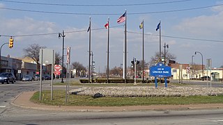
Lincoln Park is a city in Wayne County in the U.S. state of Michigan. The population was 38,144 at the 2010 census, down from 40,008 at the 2000 census. With a population density of 6,476.1/sq mi (2,500.4/km2) at the 2010 census, Lincoln Park is the second most-densely populated municipality in the state after Hamtramck.

The Territory of Michigan was an organized incorporated territory of the United States that existed from June 30, 1805, until January 26, 1837, when the final extent of the territory was admitted to the Union as the State of Michigan. Detroit was the territorial capital.

Downriver is the unofficial name for a collection of 18 cities and townships in Wayne County, Michigan, south of Detroit, along the western shore of the Detroit River.

The Ecorse River is an 18.8-mile-long (30.3 km) river in southern Michigan. Because of its small size, it is often identified as Ecorse Creek. It flows through the Downriver section of Metro Detroit, and is a tributary of the Detroit River. The early French settlers named it the Rivière aux Écorces. They named the river after the custom they observed of the local Native American tribe, who wrapped their dead in birch or elm bark, and buried them at the mouth of the river. The river has two branches, which meet at Council Point Park in the city of Lincoln Park, where chief Pontiac held a council in 1763 before attacking Fort Detroit.

Michigan's 13th congressional district is a United States congressional district in Wayne County, Michigan. It is currently represented by Democrat Rashida Tlaib.

Mongaugon Township, is a former township of Wayne County in the U.S. state of Michigan. Quarries here were worked by the French before 1749. American forces defeated British and Indian forces at the Battle of Monguagon during the War of 1812. It was first settled in 1812.

Springwells Township is a defunct civil township in Wayne County, in the U.S. state of Michigan. All of the land is now incorporated as part of the cities of Detroit and Dearborn. It is also famously known as the birthplace of Henry Ford.
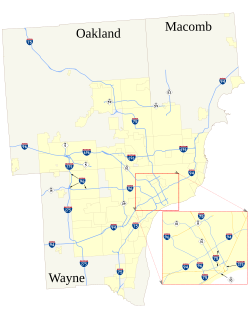
The roads and freeways in metropolitan Detroit comprise the main thoroughfares in the region. The freeways consist of an advanced network of interconnecting freeways which include Interstate highways. The Metro Detroit region's extensive toll-free freeway system, together with its status as a major port city, provide advantages to its location as a global business center. There are no toll roads in Michigan.

Old Homestead is a neighborhood on the east side of the Metro Detroit suburb of Southgate, Michigan. Usually, Old Homestead is bordered by Superior Street to the north, Eureka Road to the south, M-85 to the east and either Trenton Road or Burns Street to the west. Commercial districts are located along Eureka Road and Fort Street and the rest of the neighborhood is mostly single-family homes, most of which were built during the 1940s and 1950s. The most common housing styles within Old Homestead consist of one-story ranch homes, one-and-a-half-story Cape Cods and two-story colonial revivals.

