Edgbaston Waterworks

Last updated

Edgbaston Waterworks Edgbaston Waterworks.jpg
Edgbaston Waterworks

Edgbaston Waterworks (Edgbaston Pumping Station) (grid reference SP0455386465 ) lies to the east of Edgbaston Reservoir, two miles west of the centre of Birmingham, England.

Contents

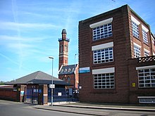
The buildings were designed by John Henry Chamberlain and William Martin around 1870. The engine house, boiler house, and chimney are Grade II listed buildings. The site is operated by Severn Trent Water. Despite the close proximity to Edgbaston Reservoir there is no current or historical connection of the water. This waterworks manages domestic water supply whereas the reservoir was built to feed the canal system.

It has been suggested, [1] [2] but not proven, that the towers of Perrott's Folly and Edgbaston Waterworks may have influenced references to towers in the writings of J. R. R. Tolkien, who lived nearby as a child.

See also

Related Research Articles

Birmingham Canal Navigations

Birmingham Canal Navigations (BCN) is a network of canals connecting Birmingham, Wolverhampton, and the eastern part of the Black Country. The BCN is connected to the rest of the English canal system at several junctions.

Elan Valley Reservoirs

The Elan Valley Reservoirs are a chain of man-made lakes created from damming the Elan and Claerwen rivers within the Elan Valley in Mid Wales. The reservoirs, which were built by the Birmingham Corporation Water Department, provide clean drinking water for Birmingham in the West Midlands of England. The five lakes are known as the Claerwen, Craig-goch, Pen-y-garreg, Garreg-ddu, and Caban-coch.

Edgbaston Area in the city of Birmingham, England

Edgbaston is a mostly affluent suburban area of central Birmingham, England, historically in Warwickshire, and curved around the southwest of the city centre.

Perrotts Folly Tall tower built in 1758 in Birmingham, United Kingdom

Perrott's Folly, grid reference SP047862, also known as The Monument, or The Observatory, is a 29-metre (96-foot) tall tower, built in 1758. It is a Grade II* listed building in the Edgbaston area of Birmingham, United Kingdom.

Sarehole

Sarehole is an area in Hall Green, Birmingham, England. Historically in Worcestershire, it was a small hamlet in the larger parish, and manor, of Yardley, which was transferred to Birmingham in 1911. Birmingham was classed as part of Warwickshire until 1974, and since then has been part of the West Midlands.

Architecture of Birmingham Overview of the architecture of Birmingham

Although Birmingham in England has existed as a settlement for over a thousand years, today's city is overwhelmingly a product of the 18th, 19th, and 20th centuries, with little surviving from its early history. As it has expanded, it has acquired a variety of architectural styles. Buildings of most modern architectural styles in the United Kingdom are located in Birmingham. In recent years, Birmingham was one of the first cities to exhibit the blobitecture style with the construction of the Selfridges store at the Bullring Shopping Centre.

Edgbaston Reservoir Reservoir in the West Midlands, England

Edgbaston Reservoir, originally known as Rotton Park Reservoir and referred to in some early maps as Rock Pool Reservoir, is a canal feeder reservoir in Birmingham, England, maintained by the Canal & River Trust. It is situated close to Birmingham City Centre and is a Site of Importance for Nature Conservation.

Birmingham Conservation Trust

Birmingham Conservation Trust is a charity which saves and restores historic buildings in the city of Birmingham, England.

Birmingham Oratory

The Birmingham Oratory is an English Catholic religious community of the Congregation of the Oratory of St. Philip Neri, located in the Edgbaston area of Birmingham. The community was founded in 1849 by St. John Henry Newman, Cong.Orat., the first house of that congregation in England.

The year 1758 in architecture involved some significant events.

South Staffordshire Water

South Staffordshire Water plc known as South Staffs Water is a UK water supply company owned by a privately owned utilities company serving parts of Staffordshire the West Midlands as well as small areas of surrounding counties in England. South Staffordshire Water plc is part of South Staffordshire plc. It purchased Cambridge Water in 2011. In 2013, KKR & Co. L.P., a company registered in the United States of America, acquired South Staffordshire Water from Alinda Infrastructure Fund. As of April 2018, KKR & Co. L.P., has agreed to sell its 75% equity stake in South Staffordshire plc to Arjun Infrastructure Partners (AIP). This deal will include South Staffs Water (SSW) and its non-regulated businesses, SSI Services and Echo Managed Services.

Tardebigge Engine House

Tardebigge Engine House is a former canal-pumping engine house at Tardebigge, Worcestershire, England. It is grade II listed.

Tardebigge Locks

Tardebigge Locks or the Tardebigge Flight is the longest flight of locks in the UK, comprising 30 narrow locks on a two-and-a-quarter-mile (3.6 km) stretch of the Worcester and Birmingham Canal at Tardebigge, Worcestershire. It raises the waterway 220 feet (67 m), and lies between the Tardebigge tunnel to the North and the Stoke Prior flight of six narrow locks to the South. The Tardebigge Engine House is also on this stretch.

Titford Canal

The Titford Canal is a narrow (7 foot) canal, a short branch of the Birmingham Canal Navigations (BCN) in Oldbury, West Midlands, England.

Brede Waterworks Waterworks at Brede, East Sussex, England, UK

Brede Waterworks is a waterworks at Brede, East Sussex, England. It was built to supply Hastings with drinking water. The waterworks still houses two of the three steam engines that were used to pump water from Brede to reservoirs at Fairlight and Baldslow.

Birmingham Corporation Water Department

The Birmingham Corporation Water Department was responsible for the supply of water to Birmingham, England, from 1876 to 1974. It was also known as Birmingham Corporation Waterworks Department.

Brookvale Park

Brookvale Park is located in the Stockland Green Ward of Erdington Constituency in England. The park surrounds Brookvale Park Lake. Within the park there is a bowling green, tennis courts, a children's play area and sailing club. Many local residents and groups take an active interest in the park and the lake.

Icknield Port Loop

The Icknield Port Loop is a 0.6-mile (1 km) loop of the eighteenth-century-built Old BCN Main Line canal in Birmingham, England, about 2 miles (3 km) west of the city centre, which opened to traffic on 6 November 1769 and in some definitions includes its straighter bypass built in September 1827, a 550-yard (500 m) section of the New BCN Main Line. Most of the 56 acres (23 ha) of land thereby enclosed is derelict meaning the canal serves the Canal & River Trust maintenance depot at Icknield Port and conveys water from Edgbaston Reservoir to the BCN Main Line. The enclosed land has no pedestrian or vehicular access. Icknield Port (Loop) takes its name from the Roman Icknield Street which passed nearby, the exact route of which is unknown.

Folly Pier Waterworks

Folly Pier Waterworks was a 19th-century waterworks on the Isle of Portland, Dorset, England. The building was located at East Weares, the east side of Portland, below HM Prison Portland, which it supplied water for. Today, only the foundations and walls of its reservoirs survive. The waterworks was named after Folly Pier, a pier once used for the transporting of Portland stone by sea.

The Tower Ballroom was an attraction in Birmingham, West Midlands, England, which opened to the public in March 1876 and closed permanently in 2017. It is located beside Edgbaston Reservoir. Across its history, The Tower Ballroom hosted a wide variety of events, including roller-skating and ice-skating, dancing, discos, weddings, boxing matches, theatre, and musical performances including The Smiths and New Order.

References

  1. "J. R. R. Tolkien". birmingham.gov.uk. 31 May 2007. Archived from the original on 7 June 2007. Retrieved 26 August 2007.
  2. "Tolkien's Birmingham". VirtualBrum. Archived from the original on 17 July 2007. Retrieved 26 August 2007.

Sources

Coordinates: 52°28′33″N1°56′01″W / 52.4758°N 1.9336°W / 52.4758; -1.9336