
Abernethy is a village in the Canadian province of Saskatchewan within the Rural Municipality of Abernethy No. 186 and Census Division No. 6. It is about one hour east of Regina, one hour west of Yorkton, and approximately five hours northwest of Winnipeg. To the south of Abernethy lies the Qu'Appelle Valley in which Katepwa Beach is located.

The Rural Municipality of Lumsden No. 189 is a rural municipality (RM) in the Canadian province of Saskatchewan within Census Division No. 6 and SARM Division No. 2. It is located in the south-east portion of the province.
Wadena is a town in the Canadian province of Saskatchewan, located east of Saskatoon, north of Fort Qu'Appelle and northwest of Yorkton on the eastern shore of the Quill Lakes. The town is known for its birdwatching and hunting opportunities as Quill Lakes is part of a major flight path. The Wadena and District Museum, located just south of Wadena on Highway 35, also hosts an annual Vintage Day in July.
Balcarres ; 2006 population 598) is a town located in southern Saskatchewan, Canada along Highway 10 and Highway 22, approximately 85 kilometres (53 mi) northeast of Regina. Highways 619 and 310 are nearby highways to this community. The town is about 15 kilometres (9.3 mi) northeast of the Fishing Lakes.

Lebret is a village in the Canadian province of Saskatchewan within the Rural Municipality of North Qu'Appelle No. 187 and Census Division No. 6. The village is situated on Mission Lake of the Fishing Lakes in the Qu'Appelle Valley. Lebret is located along Highway 56, about 70 km (43 mi) northeast of the City of Regina. The village was named after "the parish priest, Father Louis Lebret, who became the first postmaster of the community and, although he only held the position for a little more than six months, the office was named Lebret and the name became that of the community."

The Rural Municipality of North Qu'Appelle No. 187 is a rural municipality (RM) in the Canadian province of Saskatchewan within Census Division No. 6 and SARM Division No. 1. It is located in the south-east portion of the province.

Belle Plaine is a village in the Canadian province of Saskatchewan within the Rural Municipality of Pense No. 160 and Census Division No. 6. Belle Plaine is located on Highway 1, 21 kilometres east of the City of Moose Jaw in south-central Saskatchewan. Buffalo Pound Provincial Park and Regina Beach are located near Belle Plaine.
Marquis is a village in the Canadian province of Saskatchewan within the Rural Municipality of Marquis No. 191 and Census Division No. 7. It is on Highway 42 about 32 km northwest of Moose Jaw.
Lemberg is a town in Saskatchewan, Canada. It was founded by ethnic German immigrants from Lviv, for which the German name was "Lemberg", as part of the Great Economic Emigration away from Galicia and Lodomeria starting in the mid to late-1800s.

The Rural Municipality of South Qu'Appelle No. 157 is a rural municipality (RM) in the Canadian province of Saskatchewan within Census Division No. 6 and SARM Division No. 1. It is located in the southeast portion of the province.
Duff is a special service area in the Canadian province of Saskatchewan within the Rural Municipality of Stanley No. 215 and Census Division No. 5. It is approximately 122 kilometres (76 mi) north-east of the city of Regina, 66 kilometres (41 mi) south-west of Yorkton, and 20 kilometres (12 mi) west of Melville. The community is situated along Highway 10.
Lipton is a village in the Canadian province of Saskatchewan within the Rural Municipality of Lipton No. 217 and Census Division No. 6. The village is located 17 km (11 mi) north of the Town of Fort Qu'Appelle on Highway 22.
McLean is a village in the Canadian province of Saskatchewan within the Rural Municipality of South Qu'Appelle No. 157 and Census Division No. 6. It is on Highway 1 between Qu'Appelle and Balgonie. The village of McLean is located in South Central Saskatchewan on the Trans-Canada Highway and is the highest point on the Canadian Pacific Railway mainline east of the Rockies. It is about 37 kilometres (23 mi) east of the Regina. The population of McLean is 405.
Taylor Beach is a hamlet in the Canadian province of Saskatchewan.
Tantallon is a village in the Canadian province of Saskatchewan within the Rural Municipality of Spy Hill No. 152 and Census Division No. 5. It is in the Qu'Appelle Valley along the Qu'Appelle River about 39 km east of Round Lake (Saskatchewan). The community celebrated its centennial in 2004.
Tugaske is a village in the Canadian province of Saskatchewan within the Rural Municipality of Huron No. 223 and Census Division No. 7. It is nicknamed Gateway to Lake Diefenbaker. It is near Eyebrow Lake, a prairie lake in the Qu'Appelle Valley. It was named after an eyebrow-shaped hill also in the Qu'Appelle Valley above Eyebrow Lake. The lake, which is 9 km long and 1 km wide, is a bird sanctuary and is near Highway 627.

Tuxford is a village in the Canadian province of Saskatchewan within the Rural Municipality of Marquis No. 191 and Census Division No. 7. Moose Jaw is 14 kilometres (8.7 mi) south and Buffalo Pound Lake is 16 kilometres (9.9 mi) north. Highway 2, Highway 42 and Highway 202 all intersect in the community. Highway 202 connects the community to Buffalo Pound Provincial Park 11 kilometres (6.8 mi) to the east.
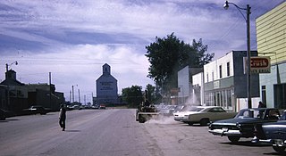
Osage is a village in the Canadian province of Saskatchewan within the Rural Municipality of Fillmore No. 96 and Census Division No. 2. The village is located on Highway 33, that runs south-east from Regina to Stoughton. The village has a grain elevator, post office, service station, and a two-sheet natural ice curling rink. Children from the area attend school in Fillmore, 13 km away. Osage celebrated its centennial in 2006.
Bird's Point is a resort village in the Canadian province of Saskatchewan within Census Division No. 5 and the Rural Municipality of Fertile Belt No. 183. The community is on the northern shore of Round Lake in the eastern part of the Qu'Appelle Valley.
The Rural Municipality of Lipton No. 217 is a rural municipality (RM) in the Canadian province of Saskatchewan within Census Division No. 6 and SARM Division No. 1.

