Eerbeek

Last updated
Eerbeek
Eerbeek, straatzicht Stuijvenburchstraat foto1 2014-03-10 13.31.jpg
Eerbeek, street view: de Stuijvenburchstraat
2010-NL-P05-Gelderland-positiekaart-gemnamen.jpg
Red pog.svg
Eerbeek
Location in the province of Gelderland in the Netherlands
Netherlands location map.svg
Red pog.svg
Eerbeek
Eerbeek (Netherlands)
Coordinates: 52°06′19″N6°03′48″E / 52.10528°N 6.06333°E / 52.10528; 6.06333 Coordinates: 52°06′19″N6°03′48″E / 52.10528°N 6.06333°E / 52.10528; 6.06333
Country Netherlands
Province Gelderland
Municipality Brummen
Area
[1]
  Total17.08 km2 (6.59 sq mi)
Elevation
[2]
20 m (70 ft)
Population
 (2021) [1]
  Total9,845
  Density580/km2 (1,500/sq mi)
Time zone UTC+1 (CET)
  Summer (DST) UTC+2 (CEST)
Postal code
6961 [1]
Dialing code 0313

Eerbeek is a town in the municipality of Brummen in the province of Gelderland in the Netherlands. Eerbeek was first mentioned in 1046 as Erbeke. In the 18th century, Eerbeek became a centre of paper production. Due to its proximity to the Veluwezoom National Park, Eerbeek is popular with tourists. [3]

Contents

History

The village was first mentioned in 1046 as Erbeke. It is named after a stream, however the etymology is unclear. [4] Eerbeek developed near the spring of the Eerdbeek. In the 18th century it became a centre of paper production. [5]

Coldenhove Castle (Dutch: Kasteel Coldenhove) was a castle used as hunting lodge by the dukes of Guelders and the princes of Orange. Nothing remains anymore of the castle.

Huis te Eerbeek is a havezate (manor house) from the 14th century. It was rebuilt in neoclassic style in 1872, however one wing of its medieval predecessor has remained. It is surrounded by a large park, and is nowadays used as hotel and a conference centre. [5] [6]

The water mill Oliemolen was built around and used to function both as an oil mill and a grist mill. A water mill was first referenced at the site in 1395. It remained in service until 1917. In 1967, the building was restored, however the grist mill part was modified into a restaurant. [7]

The Dutch Reformed church dates from 1930 and is a replacement of its 1857 predecessor. The tower which was built between 1858 and 1859 has remained and is detached from the church. [5]

Eerbeek was home to 747 people in 1840. [6] In 1887, a railway station was built on the Dieren to Apeldoorn railway line. It remained in service until 1950. [8] In 1975, it reopened as part of a museum line operated by the Veluwsche Stoomtrein Maatschappij. [5]

People from Eerbeek

Related Research Articles

<span class="mw-page-title-main">Mierlo</span> Town in North Brabant, Netherlands

Mierlo is a town in the southern Netherlands, in the municipality of Geldrop-Mierlo, North Brabant. Until 2004, it was a separate municipality with an area of 18.09 km2 (7 sq mi).

<span class="mw-page-title-main">Sexbierum</span> Village in Friesland, Netherlands

Sexbierum is a village in the municipality of Waadhoeke, in the central north of the Netherlands.

<span class="mw-page-title-main">Spaubeek</span> Village in Limburg, Netherlands

Spaubeek is a village in the Dutch province of Limburg. It is located in the municipality of Beek, about 3 km south of the town of Geleen. Spaubeek was a separate municipality until 1982, when it was merged with Beek.

<span class="mw-page-title-main">Olst</span> Town in Overijssel, Netherlands

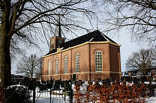
Olst is a town in the Dutch province of Overijssel, about 8 km north of Deventer. It is located in the municipality of Olst-Wijhe.

<span class="mw-page-title-main">Ouddorp</span> Village in South Holland, Netherlands

Ouddorp is a village in the Dutch province of South Holland. It is part of the municipality of Goeree-Overflakkee. It is often referred to as Ouddorp aan Zee to promote itself as a seaside resort, because the village has an 18 kilometres (11 mi) long beach which is the longest of the Netherlands.

<span class="mw-page-title-main">'s-Heer Arendskerke</span> Village in Zeeland, Netherlands

's-Heer Arendskerke is a village in the municipality of Goes in the south-western Netherlands.

<span class="mw-page-title-main">Noordlaren</span> Village in Groningen, Netherlands

Noordlaren is a village in the municipality of Groningen in the Dutch province of Groningen. It had a population of around 545 in 2021.

<span class="mw-page-title-main">Afferden, Limburg</span> Village in Limburg, Netherlands

Afferden is a village in the Dutch province of Limburg. It is a part of the municipality of Bergen (L.), and lies about 25 km southeast of Nijmegen.

<span class="mw-page-title-main">Baexem</span> Village in Limburg, Netherlands

Baexem is a village in the Dutch province of Limburg. It is a part of the municipality of Leudal, and lies about 9 kilometres northwest of Roermond.
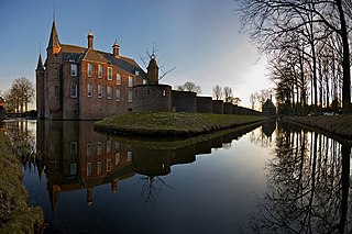
<span class="mw-page-title-main">Eanjum</span> Village in Friesland, Netherlands

Eanjum is a village in the Dutch province of Friesland. It is located in the municipality Noardeast-Fryslân and had, as of January 2017, a population of 1136.

<span class="mw-page-title-main">Waardenburg</span> Village in Gelderland, Netherlands

Waardenburg is a village in the Dutch province of Gelderland. It is a part of the municipality of West Betuwe, and is located about 13 km west of Tiel.

<span class="mw-page-title-main">Enspijk</span> Village in Gelderland, Netherlands

Enspijk is a village in the Dutch province of Gelderland. It is a part of the municipality of West Betuwe, and lies about 14km west of Tiel.

<span class="mw-page-title-main">Stevensweert</span> Village in Limburg, Netherlands

Stevensweert is a village in the Dutch province of Limburg. It is located in the municipality of Maasgouw. It lies on the right bank of the river Meuse, which forms the border with Kessenich in Belgium. There was also a ferry to this village.

<span class="mw-page-title-main">Meeuwen, Netherlands</span> Village in North Brabant, Netherlands

Meeuwen is a village in the southern Netherlands. It is located in Altena, North Brabant, about 8 km northwest of Waalwijk.

<span class="mw-page-title-main">Empe</span> Village in Gelderland, Netherlands

Empe is a village in the municipality of Brummen in the province of Gelderland in the Netherlands. Empe is located on the Apeldoorn-Zutphen railway, 4 km west of Zutphen. The NS railway station Voorst-Empe was reopened on 10 December 2006. The castle Huis Empe, built around 1550 lies on the edge of the village.

<span class="mw-page-title-main">Bybrook River</span> River in South Gloucestershire and Wiltshire, England

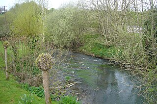
The Bybrook, also known as the By Brook, is a small river in England. It is a tributary of the Bristol Avon and is some 12 miles (19 km) long. Its sources are the Burton Brook and the Broadmead Brook, which rise in South Gloucestershire at Tormarton and Cold Ashton respectively, and join just north of Castle Combe in Wiltshire. The river has a mean flow rate of 57.25 cubic feet per second (1.621 m3/s) as recorded at Middlehill near Box. A variety of flora and fauna is supported by the river including the endangered white-clawed crayfish. Twenty watermill sites have been identified on the river but none now remain in use.

<span class="mw-page-title-main">Opbrakel</span> Village in Flemish Region

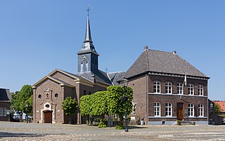
Opbrakel is a village and deelgemeente (sub-municipality) of the municipality of Brakel. It is located in the Denderstreek in the province of East Flanders in Belgium. It used to be an independent municipality until 1971 when it was merged into Brakel.

<span class="mw-page-title-main">Ten Post</span> Village in Groningen, Netherlands

Ten Post is a village in the Dutch province of Groningen. It is part of the municipality of Groningen. The village is located along the Damsterdiep and about 14 kilometres (8.7 mi) from Groningen.

<span class="mw-page-title-main">Beugen</span> Village in North Brabant, Netherlands

Beugen is a village in the Dutch province of North Brabant. It is part of the municipality of Land van Cuijk. Beugen is located along the Maas and about 20 kilometres (12 mi) south of Nijmegen.

<span class="mw-page-title-main">Coldenhove Castle</span> Former castle at Eerbeek, the Netherlands


Coldenhove Castle was a castle in Eerbeek, the Netherlands. Due to its excellent location in the Veluwe, the castle used as hunting lodge by the dukes of Guelders and the princes of Orange. Nothing remains anymore of the castle or its gardens.

References

  1. 1 2 3 "Kerncijfers wijken en buurten 2021". Central Bureau of Statistics. Retrieved 13 April 2022.
  2. "Postcodetool for 6961AA". Actueel Hoogtebestand Nederland (in Dutch). Het Waterschapshuis. Retrieved 13 April 2022.
  3. "Huis Te Eerbeek". Veluwe actief (in Dutch). Retrieved 13 April 2022.
  4. "Eerbeek - (geografische naam)". Etymologiebank (in Dutch). Retrieved 13 April 2022.
  5. 1 2 3 4 Ronald Stenvert & Sabine Broekhoven (2000). "Eerbeek" (in Dutch). Zwolle: Waanders. p. 117. ISBN   90 400 9406 3 . Retrieved 13 April 2022.
  6. 1 2 "Eerbeek". Plaatsengids (in Dutch). Retrieved 13 April 2022.
  7. "watermolen". Molen database (in Dutch). Retrieved 13 April 2022.
  8. "station Eerbeek". Stationsweb (in Dutch). Retrieved 13 April 2022.