Egarkunr

Last updated

Egarkunr
Egarkund
Census Town
India Jharkhand location map.svg
Red pog.svg
Egarkunr
Location in Jharkhand, India
India location map 3.png
Red pog.svg
Egarkunr
Egarkunr (India)
Coordinates: 23°45′N86°46′E / 23.75°N 86.77°E / 23.75; 86.77
CountryFlag of India.svg  India
State Jharkhand
District Dhanbad
CD block Nirsa
Area
  Total2.462 km2 (0.951 sq mi)
Population
 (2011)
  Total11,829
  Density4,800/km2 (12,000/sq mi)
Languages
  Official Hindi, Urdu
Time zone UTC+5:30 (IST)
PIN
828203
Vehicle registration JH 10
Lok Sabha constituency Dhanbad
Vidhan Sabha constituency Nirsa
Website dhanbad.nic.in

Egarkunr is a census town in Nirsa CD block in Dhanbad Sadar subdivision of Dhanbad district in the state of Jharkhand, India.

Contents

Geography

Egarkunr
Cities, towns and locations in the eastern portion of Dhanbad Sadar subdivision in Dhanbad district
M: Municipality, CT: Census town, N: Neighbourhood, R: Rural/ Urban centre, D: Dam, P: Power Plant
Owing to space constraints in the small map, the actual locations in a larger map may vary slightly

Location

Egarkunr is located at 23°45′N86°46′E / 23.75°N 86.77°E / 23.75; 86.77 .

Note: The map alongside presents some of the notable locations in the area. All places marked in the map are linked in the larger full screen map.

Overview

The region shown in the map is a part of the undulating uplands bustling with coalmines. While the Damodar flows along the southern boundary, the Barakar flows along the eastern boundary. Both the rivers form the boundary with West Bengal. Panchet Dam and Maithon Dam, along with their reservoirs, are prominently visible in the map. The entire area is covered in Nirsa (community development block). In Nirsa CD block 69% of the population live in rural areas and 31% live in urban areas. The official website of the district has announced the formation of two new CD blocks – Egarkund and Kaliasole, possibly carved out of Nirsa CD block. As of July 2019, there is no further information about the new CD blocks. BCCL operates Chanch/ Victoria Area partially within the region shown in the map. ECL operates Mugma Area fully within the region shown in the map. [1] [2] [3]

Demographics

As per the 2011 Census of India, Egarkunar had a total population of 11,829 of which 6,100 (52%) were males and 5,729 (48%) were females. Population below 6 years was 1,704. The total number of literates in Egarkunar was 7,254 (71.64% of the population over 6 years). [4]

As of 2001 India census, [5] Egarkunr had a population of 10,212. Males constitute 54% of the population and females 46%. Egarkunr has an average literacy rate of 55%, lower than the national average of 59.5%; male literacy is 66%, and female literacy is 41%. In Egarkunr, 13% of the population is under 6 years of age.

Infrastructure

Egarkunr has an area of 2.462 km2. It is 40 km from the district headquarters Dhanbad. There is a railway station at Kumardubi 2 km away. Buses are available in the town. It has 11 km roads and open drains. The two major sources of protected water supply are tap water from treated sources and uncovered wells. There are 2,119 domestic electric connections and 8 road light points. Amongst the medical facilities, it has 1 hospital with 5 beds and 12 medicine shops. Amongst the educational facilities, it has 8 primary schools and 5 middle schools. There is a secondary school at Kumardubi, a senior secondary school at Taldanga 3 km away and a general degree college at Maithon 5 km away. It has facilities for producing aluminium products. [6]

Related Research Articles

Babua Kalan is a census town in Baghmara CD Block in Dhanbad Sadar subdivision of Dhanbad district in the state of Jharkhand, India.

Chirkunda is a city and a notified area in Dhanbad Sadar subdivision of Dhanbad district in the state of Jharkhand, India.

Dumarkunda is a census town in Nirsa CD block in Dhanbad Sadar subdivision of Dhanbad district in the state of Jharkhand, India.

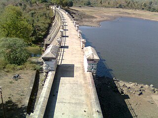
Maithon is a census town in Nirsa CD Block in Dhanbad Sadar subdivision of Dhanbad district in the Indian state of Jharkhand. It is situated on the banks of river Barakar

<span class="mw-page-title-main">Mugma</span> Village in Jharkhand, India

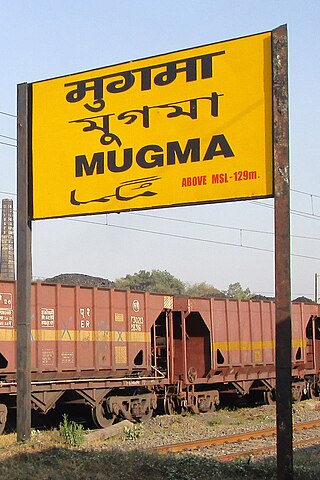
Mugma is a village in Nirsa CD Block in Dhanbad district in the Indian state of Jharkhand.

Nagri Kalan is a census town in Baghmara CD block in Dhanbad Sadar subdivision of Dhanbad district in the Indian state of Jharkhand.

Nirsa is a census town in Nirsa CD block in the Dhanbad Sadar subdivision of Dhanbad district in the Indian state of Jharkhand.

Panchet is a census town in Nirsa CD block in Dhanbad Sadar subdivision of Dhanbad district in the Indian state of Jharkhand.

Pondar Kanali is a census town in Dhanbad CD block in Dhanbad Sadar subdivision of Dhanbad district in the Indian state of Jharkhand.

Sahnidih is a census town in Baghmara CD block in Dhanbad Sadar subdivision of Dhanbad district in the Indian state of Jharkhand.

Shiblibari is a census town in Nirsa CD block in Dhanbad Sadar subdivision of Dhanbad district in the Indian state of Jharkhand.

<span class="mw-page-title-main">Topchanchi</span> Census Town in Jharkhand, India

Topchanchi is a census town in Topchanchi CD block in Dhanbad Sadar subdivision of Dhanbad district in the Indian state of Jharkhand.

Mera is a census town in Nirsa CD block in Dhanbad Sadar subdivision of Dhanbad district in the Indian state of Jharkhand.

Marma is a census town in Nirsa CD block in Dhanbad Sadar subdivision of Dhanbad district in the Indian state of Jharkhand.

Kumardhubi is an inhabited place in the Dhanbad district of Jharkhand state, India.

Nirsa is a community development block that forms an administrative division in Dhanbad Sadar subdivision of Dhanbad district, Jharkhand state, India.

Bhamal is a census town in Nirsa CD block in Dhanbad Sadar subdivision of Dhanbad district in the Indian state of Jharkhand.

Panrra is a census town in Nirsa CD block in Dhanbad Sadar subdivision of Dhanbad district in the Indian state of Jharkhand.

Panchmahali is a census town in Nirsa CD block in Dhanbad Sadar subdivision of Dhanbad district in the Indian state of Jharkhand.

<span class="mw-page-title-main">Kaliasole</span> Village in Jharkhand, India

Kaliasole is a village in Kaliasole in Dhanbad Sadar subdivision of Dhanbad district of State Capital Ranchi in the Indian state of Jharkhand.

References

  1. "District Census Handbook Dhanbad" (PDF). Series 21, Part XIIA, pages 4-5, 5-6, 8. Directorate of Census Operations, Jharkhand. Retrieved 4 June 2019.
  2. "Area". Bharat Coking Coal Limited. Archived from the original on 26 July 2019. Retrieved 2 July 2019.
  3. "Area-wise Closed User Group (CUG) Telephone Number". Eastern Coalfields Limited. Retrieved 11 August 2018.
  4. "2011 Census C.D. Block Wise Primary Census Abstract Data(PCA)". Jharkhand – District-wise CD Blocks. Registrar General and Census Commissioner, India. Retrieved 11 June 2019.
  5. "Census of India 2001: Data from the 2001 Census, including cities, villages and towns (Provisional)". Census Commission of India. Archived from the original on 16 June 2004. Retrieved 1 November 2008.
  6. "District Census Handbook, Dhanbad, 2011, Series 21, Part XII A" (PDF). Pages 639-664 Statements. Directorate of Census Operations, Jharkhand. Retrieved 9 June 2019.