Eggenwil

Last updated
Eggenwil
Eggenwil Preghejo 161.jpg
Wappen Eggenwil.svg
Location of Eggenwil
Eggenwil
Switzerland adm location map.svg
Red pog.svg
Eggenwil
Reliefkarte Aargau blank.png
Red pog.svg
Eggenwil
Coordinates: 47°22′N8°20′E / 47.367°N 8.333°E / 47.367; 8.333
Country Switzerland
Canton Aargau
District Bremgarten
Area
[1]
  Total2.46 km2 (0.95 sq mi)
Elevation
383 m (1,257 ft)
Population
 (31 December 2018) [2]
  Total1,053
  Density430/km2 (1,100/sq mi)
Time zone UTC+01:00 (Central European Time)
  Summer (DST) UTC+02:00 (Central European Summer Time)
Postal code(s)
5445
SFOS number 4066
Surrounded by Bellikon, Bremgarten, Fischbach-Göslikon, Künten, Widen, Zufikon
Website www.eggenwil.ch
SFSO statistics
Eggenwil Karte Gemeinde Eggenwil 2010.png
Eggenwil

Eggenwil is a municipality in the district of Bremgarten in the canton of Aargau in Switzerland.

Contents

History

Map of the Freie Amter including Amt Hermetschwil Landvogtei Freie Aemter.png
Map of the Freie Ämter including Amt Hermetschwil

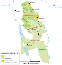
Eggenwil is first mentioned about 1160 as Egenwilare in a donation document, the Acta Murensia. The village and church were given by Albert II, Count of Habsburg (died 1140) to Muri Abbey. However, the Habsburg rights of Low justice were given to the Hermetschwil abbey. In 1415 the canton of Aargau was taken from the Habsburgs by the Swiss Confederates. While Bern kept the southwest portion (Zofingen, Aarburg, Aarau, Lenzburg, and Brugg). Some districts, named the Freie Ämter or free bailiwicks, with the County of Baden, were governed as "subject lands" by all or some of the Confederates. Part of Eggenwil was transferred to the Amt Hermetschwil of the Freie Ämter, and the portions of the village north of the main road became part of the County of Baden. During the Helvetic Republic (1798–1803) Eggenwil and Widen formed a single municipality. Since the end of the Helvetic Republic, Eggenwil has been an independent municipality 1798–1803.

The village church, St. Lawrence's Church, was built in 1064 and converted into a Swiss Reformed Church in 1529 during the Protestant Reformation. In 1683 the choir was renovated. The parish of Eggenwil has existed since 1944.

Until a phylloxera outbreak in the 19th century, vineyards were the main source of income for the municipality. In 2000 less than one fifth of the workforce in Eggenwil works in the secondary sector of the economy while more than half work in the tertiary sector. Approximately three quarters of the working population were commuters, especially in the region of Baden and Zurich. [3]

Geography

Fire station built into a hill side in Eggenwil Eggenwil-Fajrobrigadejo 156.jpg
Fire station built into a hill side in Eggenwil

Eggenwil has an area, as of 2006, of 2.5 square kilometers (0.97 sq mi). Of this area, 54.7% is used for agricultural purposes, while 27.5% is forested. Of the rest of the land, 12.1% is settled (buildings or roads) and the remainder (5.7%) is non-productive (rivers or lakes). [4]

The municipality is located in the Bremgarten district, on a terrace at the foot of the Hasenberg and along the right bank of the Reuss river.
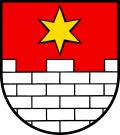
Coat of arms

The blazon of the municipal coat of arms is Gules Walls embattled Argent masoned Sable issuant from base and in chief a Mullet Or. [5]

Demographics

Eggenwil has a population (as of 31 December 2020) of 1,042. [6] As of 2008, 15.9% of the population was made up of foreign nationals. [7] Over the last 10 years the population has grown at a rate of 20.2%. Most of the population (as of 2000) speaks German (94.8%), with French being second most common ( 1.0%) and Portuguese being third ( 1.0%). [4]

The age distribution, as of 2008, in Eggenwil is; 76 children or 9.4% of the population are between 0 and 9 years old and 86 teenagers or 10.6% are between 10 and 19. Of the adult population, 95 people or 11.7% of the population are between 20 and 29 years old. 102 people or 12.6% are between 30 and 39, 155 people or 19.1% are between 40 and 49, and 150 people or 18.5% are between 50 and 59. The senior population distribution is 92 people or 11.4% of the population are between 60 and 69 years old, 45 people or 5.6% are between 70 and 79, there are 6 people or 0.7% who are between 80 and 89,and there are 3 people or 0.4% who are 90 and older. [8]

As of 2000 the average number of residents per living room was 0.55 which is about equal to the cantonal average of 0.57 per room. In this case, a room is defined as space of a housing unit of at least 4 m2 (43 sq ft) as normal bedrooms, dining rooms, living rooms, kitchens and habitable cellars and attics. [9] About 65.9% of the total households were owner occupied, or in other words did not pay rent (though they may have a mortgage or a rent-to-own agreement). [10] As of 2000, there were 26 homes with 1 or 2 persons in the household, 97 homes with 3 or 4 persons in the household, and 132 homes with 5 or more persons in the household. The average number of people per household was 2.48 individuals. [11] In 2008 there were 182 single family homes (or 47.5% of the total) out of a total of 383 homes and apartments. [12] There were a total of 26 empty apartments for a 6.8% vacancy rate. [12] As of 2007, the construction rate of new housing units was 7.9 new units per 1000 residents. [4]

In the 2007 federal election the most popular party was the SVP which received 39.2% of the vote. The next three most popular parties were the SP (18.5%), the CVP (14.8%) and the FDP (12.1%). [4]

The entire Swiss population is generally well educated. In Eggenwil about 81.1% of the population (between age 25 and 64) have completed either non-mandatory upper secondary education or additional higher education (either university or a Fachhochschule ). [4] Of the school age population (in the 2008/2009 school year), there are 48 students attending primary school in the municipality. [11]

The historical population is given in the following table: [3]

Historical population
YearPop.±%
1850 281    
1900 219−22.1%
1950 270+23.3%
2000 669+147.8%

Economy

As of  2007, Eggenwil had an unemployment rate of 1.81%. As of 2005, there were 32 people employed in the primary economic sector and about 6 businesses involved in this sector. 15 people are employed in the secondary sector and there are 4 businesses in this sector. 66 people are employed in the tertiary sector, with 27 businesses in this sector. [4]

As of 2000 there were 384 total workers who lived in the municipality. Of these, 312 or about 81.3% of the residents worked outside Eggenwil while 67 people commuted into the municipality for work. There were a total of 139 jobs (of at least 6 hours per week) in the municipality. [13] Of the working population, 11.3% used public transportation to get to work, and 60.8% used a private car. [4]

Religion

Village Church of Eggenwil Eggenwil Preghejo 155.jpg
Village Church of Eggenwil

From the 2000 census, 289 or 43.2% were Roman Catholic, while 249 or 37.2% belonged to the Swiss Reformed Church. [11]

Related Research Articles

<span class="mw-page-title-main">Bellikon</span> Municipality in Aargau, Switzerland

Bellikon is a municipality in the district of Baden in the canton of Aargau in Switzerland.

<span class="mw-page-title-main">Berikon</span> Municipality in Aargau, Switzerland

Berikon is a municipality in the district of Bremgarten in the canton of Aargau in Switzerland.

<span class="mw-page-title-main">Bremgarten, Aargau</span> Municipality in Aargau, Switzerland

Bremgarten is a municipality in the Swiss canton of Aargau. It serves as seat of the district of Bremgarten. The medieval old town is listed as a heritage site of national significance. In 2013, Bremgarten was the first municipality in Europe to introduce laws forbidding asylum seekers from visiting certain public places such as libraries, swimming pools, schools and churches.

Bremgarten District is a Swiss district in the Canton of Aargau, corresponding to the valleys of the Reuss and Bünz rivers in the area known as the Freiamt.

<span class="mw-page-title-main">Fischbach-Göslikon</span> Municipality in Aargau, Switzerland

Fischbach-Göslikon is a municipality in the district of Bremgarten in the canton of Aargau in Switzerland.

<span class="mw-page-title-main">Islisberg</span> Municipality in Aargau, Switzerland

Islisberg is a municipality in the district of Bremgarten in the canton of Aargau in Switzerland.

<span class="mw-page-title-main">Widen</span> Municipality in Aargau, Switzerland

Widen is a municipality in the district of Bremgarten in the canton of Aargau in Switzerland.

<span class="mw-page-title-main">Rudolfstetten-Friedlisberg</span> Municipality in Aargau, Switzerland

Rudolfstetten-Friedlisberg is a municipality in the district of Bremgarten in the canton of Aargau in Switzerland. Prior to 1953, the municipality was officially known simply as Rudolfstetten.

<span class="mw-page-title-main">Zufikon</span> Municipality in Aargau, Switzerland

Zufikon is a municipality in the district of Bremgarten in the canton of Aargau in Switzerland.

<span class="mw-page-title-main">Rothrist</span> Municipality in Aargau, Switzerland

Rothrist is a municipality in the district of Zofingen in the canton of Aargau in Switzerland.

<span class="mw-page-title-main">Rottenschwil</span> Municipality in Aargau, Switzerland

Rottenschwil is a municipality in the district of Muri in the canton of Aargau in Switzerland.

<span class="mw-page-title-main">Gebenstorf</span> Municipality in Aargau, Switzerland

Gebenstorf is a municipality in the district of Baden in the canton of Aargau in Switzerland.

<span class="mw-page-title-main">Künten</span> Municipality in Aargau, Switzerland

Künten is a municipality in the district of Baden in the canton of Aargau in Switzerland. It lies on the Reuss River and includes the previously independent community of Sulz, which merged with Künten in 1973.

<span class="mw-page-title-main">Obersiggenthal</span> Municipality in Aargau, Switzerland

Obersiggenthal is a municipality located in the Limmat Valley, within the district of Baden, in the canton of Aargau, Switzerland.

<span class="mw-page-title-main">Hermetschwil-Staffeln</span> Former municipality in Aargau, Switzerland

Hermetschwil-Staffeln is a former municipality in the district of Bremgarten in the canton of Aargau in Switzerland. On 1 January 2014 the former municipality of Hermetschwil-Staffeln merged into the municipality of Bremgarten.

<span class="mw-page-title-main">Jonen</span> Municipality in Aargau, Switzerland

Jonen is a municipality in the district of Bremgarten in the canton of Aargau in Switzerland.

<span class="mw-page-title-main">Oberlunkhofen</span> Municipality in Aargau, Switzerland

Oberlunkhofen is a municipality in the district of Bremgarten, in the canton of Aargau in Switzerland.

<span class="mw-page-title-main">Sarmenstorf</span> Municipality in Aargau, Switzerland

Sarmenstorf is a municipality in the district of Bremgarten in the canton of Aargau in Switzerland.

<span class="mw-page-title-main">Villmergen</span> Municipality in Aargau, Switzerland

Villmergen is a municipality in the district of Bremgarten in the canton of Aargau in Switzerland.

<span class="mw-page-title-main">Wohlen, Aargau</span> Municipality in Aargau, Switzerland

Wohlen is a municipality in the district of Bremgarten in the canton of Aargau in Switzerland.

References

  1. "Arealstatistik Standard - Gemeinden nach 4 Hauptbereichen". Federal Statistical Office. Retrieved 13 January 2019.
  2. "Ständige Wohnbevölkerung nach Staatsangehörigkeitskategorie Geschlecht und Gemeinde; Provisorische Jahresergebnisse; 2018". Federal Statistical Office. 9 April 2019. Retrieved 11 April 2019.
  3. 1 2 Eggenwil in German , French and Italian in the online Historical Dictionary of Switzerland .
  4. 1 2 3 4 5 6 7 Swiss Federal Statistical Office Archived January 5, 2016, at the Wayback Machine accessed 18-February-2010
  5. Flags of the World.com Archived 2011-06-04 at the Wayback Machine accessed 18-February-2010
  6. "Ständige und nichtständige Wohnbevölkerung nach institutionellen Gliederungen, Geburtsort und Staatsangehörigkeit". bfs.admin.ch (in German). Swiss Federal Statistical Office - STAT-TAB. 31 December 2020. Retrieved 21 September 2021.
  7. Statistical Department of Canton Aargau -Bereich 01 -Bevölkerung Archived 2012-02-22 at the Wayback Machine (in German) accessed 20 January 2010
  8. Statistical Department of Canton Aargau -Bevölkerungsdaten für den Kanton Aargau und die Gemeinden (Archiv) Archived 2012-02-22 at the Wayback Machine (in German) accessed 20 January 2010
  9. Eurostat. "Housing (SA1)". Urban Audit Glossary (PDF). 2007. p. 18. Archived from the original (PDF) on 14 November 2009. Retrieved 12 February 2010.
  10. Urban Audit Glossary pg 17
  11. 1 2 3 Statistical Department of Canton Aargau - Aargauer Zahlen 2009 Archived 2012-02-22 at the Wayback Machine (in German) accessed 20 January 2010
  12. 1 2 Statistical Department of Canton Aargau Archived 2012-02-22 at the Wayback Machine (in German) accessed 20 January 2010
  13. Statistical Department of Canton Aargau-Bereich 11 Verkehr und Nachrichtenwesen Archived 2012-02-22 at the Wayback Machine (in German) accessed 21 January 2010