El Fuerte de Samaipata

Last updated
El Fuerte de Samaipata
View of Fort Samaipata Rock.jpg
View of the sculptured rock at El Fuerte
Bolivia adm location map.svg
Archaeological site icon (red).svg
Shown within Bolivia
Location Santa Cruz Department, Bolivia
Region Andes
Coordinates 18°10′42.08″S63°49′8.36″W / 18.1783556°S 63.8189889°W / -18.1783556; -63.8189889 Coordinates: 18°10′42.08″S63°49′8.36″W / 18.1783556°S 63.8189889°W / -18.1783556; -63.8189889
History
Founded300 CE
Cultures Chané, Incan, Spanish
Official nameFuerte de Samaipata
TypeCultural
Criteriaii, iii
Designated1998 (22nd session)
Reference no. 883
Region Latin America and the Caribbean

El Fuerte de Samaipata or Fort Samaipata, also known simply as "El Fuerte", is a Pre-Columbian archaeological site and UNESCO World Heritage Site located in Florida Province, Santa Cruz Department, Bolivia. [1] It is situated in the eastern foothills of the Bolivian Andes and is a popular tourist destination for Bolivians and foreigners alike. It is served by the nearby town of Samaipata. The archaeological site at El Fuerte is unique as it encompasses buildings of three different cultures: Chanè, Inca, and Spanish. [2]

Contents

Although called a fort, Samaipata had also a religious, ceremonial, and residential function. Its construction was probably begun by the Chané, a pre-Inca people of Arawak origin. There are also ruins of an Inca plaza and residences, dating from the late 15th and early 16th centuries as the Inca empire expanded eastward from the Andes highlands into the sub-tropical foothills. Chané, Inca, and Spanish all suffered raids from Guarani (Chiriguano) warriors who also settled in the region. The Guarani conquered the plains and valleys of Santa Cruz and occupied the Samaipata area. The Guaranis dominated the region well into the Spanish colonial period. [3]

The Spaniards built a settlement at Samaipata fort, and there are remains of buildings of typical Arab Andalusian architecture. The Spaniards soon abandoned the fort and moved to a nearby valley, establishing the town of Samaipata in 1618. [4]

Incas

The site of Samaipata was occupied as a ritual and residential area about 300 CE by the Chané of the Mojocoyas period (200 to 800 CE). They began shaping the great rock that is the ceremonial center of the Samaipata ruin. [5]

According to a 17th-century Spanish chronicler, Diego Felipe de Alcaya, the Incas, probably late in the reign of Tupac Yupanqui (ruled 1471-1493), began the incorporation of the Samaipata area into the empire. A relative of Yupanqui's named Guacane led an Inca army to the area and with elaborate gifts persuaded the local leader, whose title was Grigota, and his 50,000 subjects to submit to Inca rule. Guacane established his capital at Samaipata or Sabay Pata on a mountain top at an elevation of 1,900 metres (6,200 ft). Samaipata means "the heights of rest" in the Quechua language spoken by the Inca. [6]

Samaipata was an Inca administrative, ceremonial, and religious center. As with other Inca administrative centers on the frontiers of the empire (such as Oroncota), Samaipata was protected by outlying fortresses. One has been located about 50 kilometres (31 mi) to the east called La Fortaleza. The ruins of the fort are on a mountaintop overlooking the lowlands around the present-day city of Santa Cruz. [7] Another fortress. location unknown, called Guanacopampa protected a mine at Saypurú or Caypurum, location also unknown. [8] The Samaipata area was one of the most isolated and easternmost areas of the Inca Empire.

According to Alcaya's account, Guacane and Grigota were killed in an attack by the Eastern Bolivian Guaraní people called Chiriguanos by the Spanish. The Chiriguanos were advancing from the lowlands into the Andes foothills. A counterattack by the Incas failed to dispossess the Chiriguanos who remained to settle in Samaipata and its vicinity. An Inca building destroyed by fire at Samaipata gives credence to this story. [9] The date of the war is uncertain, although many authorities date the beginning of Chiriguano attacks on the Inca's eastern frontiers to the 1520s. [10]

The Spanish, along with Inca supporters, may have used Samaipata as a fortress and base camp as early as the 1570s, but formal Spanish settlement began in 1615 while the Chiriguanos were still threatening. A Spanish house is among the ruins. [11]

The site

The carved rock at Samaipata Fort. Samaipata.jpg
The carved rock at Samaipata Fort.

The Samaipata archaeological site of about 20 hectares (49 acres) is divided into two parts: a ceremonial sector and an administrative/residential sector. Some of the construction of the Inca were built on earlier structures of the Chané.

The ceremonial sector is in the northern part of the site. It is about 220 metres (720 ft) by 60 metres (200 ft) and consists mostly of a large rock saddle almost completely covered with carvings of both Inca and pre-Inca origin. The carvings include a variety of geometric and animal figures, walls, niches, and long canal-like carvings called "the spine of the serpent" or "el cascabel" (the rattlesnake). Although not the most visually spectacular, the most important part of the ceremonial sector is the "coro de los sacerdotes" (choir of the priests) at the highest point of the rock. This consists of 18 niches, probably used as seats for individuals, carved into the rock. At the bottom of the rock are 21 carved rectangular niches which may have served as residences for priests or for the storage of ceremonial items. Other niches and alcoves are scattered around the ruin. [12]

The residential and administrative center makes up the southern part of the site. Samaipata may have been an Incan provincial capital and has all the infrastructure associated with that status. [13] The most prominent feature is a large trapezoidal plaza about 100 metres (330 ft) on each side bordered on the south by a "kallanka," a rectangular building typical of Inca cities and symbolizing Incan political power. The kallanka, 70 metres (230 ft) in length and 16 metres (52 ft) wide was used for public gatherings, feasts, and housing visitors and soldiers. The kallanka at Samaipata is the second largest in Bolivia, but apparently construction was interrupted as the drainage canal and thatched roof were not completed. [14]

Also in this sector is the Acllahuasi, a nunnery for the sequestered women called Aclla, who were chosen to weave textiles, become wives of Inca nobles, participate in ceremonies, and, on occasion, be sacrificed in religious ceremonies. The existence of an Acllahuasi was typical of important Inca settlements. [15]

Protection

Due to damage caused by visitors walking on the symbols cut into the rock and by erosion caused by water, the inner area is cordoned off to prevent more damage. However most of it can still be viewed.

Access to the site is easy; many operators run buses from nearby Samaipata. There is a small entrance charge. The site is under the care of Stonewatch, which is a non profit society and academy for conservation and documentation of rock art.

The view from the Samaipata Fort Scenery at the UNESCO, El Fuerte de Samaipata site, including La Muela, the tabletop mountain in the center of the horizon.jpg
The view from the Samaipata Fort

Related Research Articles

<span class="mw-page-title-main">Chicha</span> Beverage from prehispanic Latin America

Chicha is a fermented (alcoholic) or non-fermented beverage of Latin America, emerging from the Andes and Amazonia regions. In both the pre- and post-Spanish conquest periods, corn beer made from a variety of maize landraces has been the most common form of chicha. However, chicha is also made from a variety of other cultigens and wild plants, including, among others, quinoa, kañiwa, peanut, manioc, palm fruit, rice, potato, oca, and chañar. There are many regional variations of chicha. In the Inca Empire, chicha had ceremonial and ritual uses.

<span class="mw-page-title-main">Inca road system</span> Transportation system of the Inca empire

The Inca road system was the most extensive and advanced transportation system in pre-Columbian South America. It was about 40,000 kilometres (25,000 mi) long. The construction of the roads required a large expenditure of time and effort.

<span class="mw-page-title-main">Santa Cruz de la Sierra</span> Largest city in Bolivia

Santa Cruz de la Sierra, commonly known as Santa Cruz, is the largest city in Bolivia and the capital of the Santa Cruz department.

<span class="mw-page-title-main">Inkallaqta</span> Archaeological site in Bolivia

Inkallaqta is a monumental Inca site in central Bolivia. It is located in the Cochabamba Department, Carrasco Province, Pocona Municipality, approximately 130 kilometers east of Cochabamba. It was most recently excavated by Larry Coben. He believes that the site was used to perform rites for the ceremonial calendar. The site has several important structures such as the Kallanka. It was the largest single roofed room in the western hemisphere when it was built, and measures 78 by 25 meters. There's also an ushnu or a ritual platform on the site. The Torreon of Inkallaqta is also located on this site. Located at the western side of the site this six sided structure supposedly had calendrical or astronomical significance. There is a zigzag wall immediately north of the site which is meant to mark and protect it.

<span class="mw-page-title-main">Samaipata, Bolivia</span> Archaeological site in Bolivia

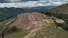
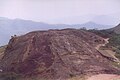
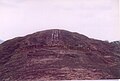
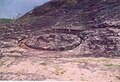
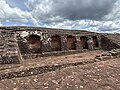
Samaipata or Samaypata is a small town in the Florida Province of the Santa Cruz Department in Bolivia. It has a subtropical climate and an altitude of 1600–1800 m. It lies about 120 kilometers to the southwest of the city of Santa Cruz de la Sierra in the foothills of the Andes on the way to Sucre. It is a popular resort for inhabitants of Santa Cruz due to its much cooler climate. As such, there is regular bus and taxi service to Santa Cruz. The town is small with numerous colonial buildings and narrow cobbled streets. It is located near several tourist attractions such as El Fuerte de Samaipata, the Amboro National Park, El Codo de los Andes, Cuevas waterfalls, vineyards, rapids and lagoons, as well as well-preserved colonial towns such as Vallegrande, Pampagrande, Postrervalle, Santiago del Valle, Pucará, and others. It is also the first stop in the several tourist trails to Sucre, Potosi, and the Che Guevara route.

<span class="mw-page-title-main">Florida Province</span> Province in Santa Cruz Department, Bolivia

Florida is a province in the Santa Cruz Department, Bolivia. Its capital is Samaipata. The province was created by law on December 15, 1924.

<span class="mw-page-title-main">Johan Reinhard</span> American anthropologist

Johan Reinhard is an Explorer-in-Residence at the National Geographic Society. He is also a senior research fellow at The Mountain Institute, a visiting professor at Catholic University, Salta, Argentina, an honorary professor of Catholic University, Arequipa, Peru, and a research professor at Future Generations University.

El Fuerte may refer to:

<span class="mw-page-title-main">Chané</span> Indigenous people of South America

Chané is the collective name for the southernmost Arawakan-speaking peoples. They lived in the plains of the northern Gran Chaco and in the foothills of the Andes in Paraguay, Brazil, Bolivia, and Argentina. The historical Chané are divided into two principal groups. The Chané proper who lived in eastern Bolivia and the Guaná who lived in Paraguay and adjacent Brazil. Twenty-first century survivors of the Chané are the Izoceno people of Bolivia and 3,034 descendants reported in Argentina by the 2010 census. Survivors of the Guaná are the Tereno and the Kinikinao both of Mato Grosso do Sul province in Brazil.

<span class="mw-page-title-main">Tourism in Bolivia</span>

Bolivia is a country with great tourism potential, with many attractions, due to its diverse culture, geographic regions, rich history and food. In particular, the salt flats at Uyuni are a major attraction.

The Children of Llullaillaco, also known as the Mummies of Llullaillaco, are three Inca child mummies discovered on 16 March 1999 by Johan Reinhard and his archaeological team near the summit of Llullaillaco, a 6,739 m (22,110 ft) stratovolcano on the Argentina–Chile border. The children were sacrificed in an Inca religious ritual that took place around the year 1500. In this ritual, the three children were drugged with coca and alcohol then placed inside a small chamber 1.5 metres (5 ft) beneath the ground, where they were left to die. Archaeologists consider them as being among the best-preserved mummies in the world.

<span class="mw-page-title-main">Huánuco Pampa</span> Archaeological site in Peru

Huánuco Pampa, Huánuco Marka or Huánuco Viejo, or Wanuku Pampa is a large archaeological site in Peru in the Huánuco Region, Dos de Mayo Province, La Unión District. The ruins of the city lie on a plateau above the Urqumayu or Vizcarra River in the central Andes. The Incas administered their large empire through a small number of administrative centers, such as Huánuco Pampa. The administrative centers were linked by the extensive Inca road system. The most important of the roads, the Qhapaq Ñan, which ran from Cusco to Quito, passed through Huánuco Pampa. The Inca authorities in Huánuco ruled at least five, and perhaps more, ethnic groups. The city is situated on an important commercial trade route and sits on top of a plateau with ravines on all sides in order to allow easy defense of the city. During the Spanish conquest of the Incas, Huánuco Pampa was briefly occupied by Gomez de Alvarado, who founded a Spanish city there but it was quickly moved because of the harsh climate and Inca raids of Illa Tupac, one of the captains of Manco Inca.

<span class="mw-page-title-main">Indigenous peoples in Bolivia</span> Bolivian people of indigenous ancestry

Indigenous peoples in Bolivia, or Native Bolivians, are Bolivian people who are of indigenous ancestry. They constitute anywhere from 40 to 70% of Bolivia's population of 11,306,341, depending on different estimates, and belong to 36 recognized ethnic groups. Aymara and Quechua are the largest groups. The geography of Bolivia includes the Andes, the Gran Chaco, and the Amazon Rainforest.

T'uqu T'uquyuq or Machu Machuyuq is an archaeological site with rock paintings in Peru. It is situated in the Cusco Region, Urubamba Province, Yucay District. The site lies at a height of about 3,150 metres (10,335 ft) on the slopes of the mountain Saywa (Sayhua).

Oroncota or Huruncuta was an Inca provincial center or capital on the border of Chuquisaca and Potosí Departments of Bolivia. Oroncota was captured by the Incas during the reign of Topa Inca Yupanqui (1471-1493) and served as a defensive outpost protecting the eastern frontiers of the Inca empire. The primary residents of the Oroncota area for more than 1,500 years have been the Yampara people. In the 16th century, during the last years of the Inca Empire and the early Spanish Empire, Oroncota and its region were under heavy attack by the Ava Guarani people (Chiriguanos) ethnic group who eventually gained control of the area.

<span class="mw-page-title-main">Ava Guarani people</span> Indigenous people in Bolivia

The Ava Guaraní are an Indigenous peoples formerly known as Chiriguanos or Chiriguano Indians who speak the Ava Guarani and Eastern Bolivian Guaraní languages. Noted for their warlike character, the Chiriguanos retained their lands in the Andes foothills of southeastern Bolivia from the 16th to the 19th centuries by fending off, first, the Inca Empire, later, the Spanish Empire, and, still later, independent Bolivia. The Chiriguanos were finally subjugated in 1892.

The Battle of Kuruyuki or Battle of Curuyuqui was fought near the town of Cuevo, Bolivia on January 28, 1892. The combatants were the Eastern Bolivian Guarani Indians and a force made up of Bolivian military, militia, and Chiriguano Indians friendly to the government and Christianity. Often described as a massacre, the battle resulted in an overwhelming victory by the government forces. In the aftermath of the battle the government forces executed the Chiriguano leader, Apiaguaiki Tumpa or Hapiaoeki Tumpa, and many captives.

The Inca-Caranqui archaeological site is located in the village of Caranqui on the southern outskirts of the city of Ibarra, Ecuador. The ruin is located in a fertile valley at an elevation of 2,299 metres (7,543 ft). The region around Caranqui, extending into the present day country of Colombia, was the northernmost outpost of the Inca Empire and the last to be added to the empire before the Spanish conquest of 1533. The archaeological region is also called the Pais Caranqui.

<span class="mw-page-title-main">Architecture of Bolivia</span>

The architecture of Bolivia is closely related to its history, culture and religion. Bolivian architecture has been constantly changing and progressing over time. Subject to terrain and high altitudes, most of Bolivia's Pre-Columbian buildings were built for housing, mainly influenced by Bolivian indigenous culture. The arrival of Spanish settlers brought many European-style buildings, and the Spaniards began planning to build big cities. After Independence, the architectural style became Neoclassical and many churches and government buildings were built. In modern Bolivia, like many countries, skyscrapers and post-modern buildings dominate, and of course there are special styles of architecture to attract tourists and build.

References

  1. "Fuerte de Samaipata--UNESCO World Heritage Centre" https://whc.unesco.org/en/list/883. Accessed 23 Sep 2016
  2. "Fuerte de Samaipata". whc.unesco.org. Retrieved 23 Sep 2016.
  3. "Fuerte de Samaipata". whc.unesco.org. Retrieved 23 Sep 2016.
  4. "Gobierno Autonomo: Santa Cruz", http://www.santacruz.gob.bo/sczturistica/florida_municipio_samaipata_datos/30000381, accessed 27 Sep 2016
  5. "Fuerte de Samaipata". whc.unesco.org. Retrieved 23 Sep 2016.
  6. Scholl, Jonathan (2015), "At the Limits of Empire: Incas, Spaniards, and the Ava-Guarani (Chiriguanaes) on the Charcas-Chiriguana Frontier, Southeastern Andes (1450s-1620s)", Dissertation, University of Florida, pp 187-188
  7. Meyers, Albert and Ulbert, Cornelius (1997), "Inka Archaeology in Eastern Bolivia: Some Aspects of the Samaipata Project," https://www.researchgate.net/publication/280917869_Inka_Archaeology_in_Eastern_Bolivia_Some_Aspects_of_the_Samaipata_Project, accessed 24 Sep 2016
  8. "El Sitio Ceremonial y Administrativo de El Fuerte de Samaipata" (Apr 2015), Tesapa Arundu, Vol. 4, No. 21, pp. 2-3, https://www.academia.edu/12331379/El_Sitio_Ceremonial_y_Administrativo_de_El_Fuerte_de_samaipata, accessed 25 Sep 2016
  9. Scholl, pp. 196-197
  10. "Fuerte de Samaipata".
  11. Meyers, Albert (2005), "Incas, Españoles y el Paytiti: la perspectiva desde el “Fuerte de Sabaypata”, Oriente de Bolivia." Archivio per L’Antropologia e la Etnologia, V.CXXXV (Atti del Convegnio Internazionale Nuove Prospettive negli Studi Andini), 167-168. https://www.academia.edu/3070986/Incas_Espa%C3%B1oles_y_el_Paytiti_la_perspectiva_desde_el_Fuerte_de_Sabaypata_Oriente_de_Bolivia_2005_, accessed 25 Sep 2016' Meyes and Ulbert. Samaipata was officially founded in 1618
  12. Muňoz Collazos, Maria de los Angeles (2015), "Samaipata, el Cerro Esculpido: Locales e Incas" (2015), Arqueoantropologiccas, Vol. 5, No. 5, pp. 13-14. https://www.academia.edu/27563088/PROYECTO_ARQUEOL%C3%93GICO_VALLES_DE_TARIJA_PAVT, accessed 27 Sep 2016
  13. Meyers and Ulbert, p 81
  14. "El Sitio Ceremonial y Administrativo de el Fuerte de samaipata". www.academia.edu. Retrieved 25 Sep 2016.
  15. "Fuerte de Samaipata". whc.unesco.org. Retrieved 23 Sep 2016.