
Sohag Governorate is one of the governorates of Egypt. It is located in the southern part of the country, and covers a stretch of the Nile Valley. Since 1960, its capital has been the city of Sohag. Prior to that, the capital was the city of Girga and the name of the governorate was Girga Governorate.
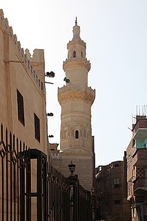
Akhmim is a city in the Sohag Governorate of Upper Egypt. Referred to by the ancient Greeks as Khemmis or Chemmis and Panopolis, it is located on the east bank of the Nile, four miles (6.4 km) to the northeast of Sohag.
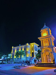
Aksaray (pronounced [ˈaksaɾaj], is a city in the Central Anatolia region of Turkey and the capital district of Aksaray Province. With an estimated 2020 population of 423,011 distributed over about 7,659 km2. The average elevation is 980 m, with the highest point being Mt. Hasan at 3,253 m.
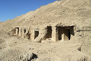
El Hawawish is the name given to the site of the ancient necropolis (cemetery) for the city of Akhmim in the Sohag Governorate, Egypt.

Sohag, also spelled as Sawhāj, Suhag and Suhaj, is a city on the west bank of the Nile in Egypt. It has been the capital of Sohag Governorate since 1960, before which the capital was Girga and the name of the governorate was Girga Governorate. It also included Esna Governorate.
Athribis, also known to the ancient Greeks as Triphieion or Tripheion, and to the ancient Egyptians as Hut-Repyt, was an ancient city of Egypt, in the Panopolite nome. The modern villages of Wannina and Nag' Hamad in the Sohag Governorate are situated nearby. It is located some 10 km (6 mi) southwest of the city of Akhmim and about 3 km (2 mi) south of the White Monastery, on the west bank of the Nile.

Fábiánháza is a village in Szabolcs-Szatmár-Bereg county, in the Northern Great Plain region of eastern Hungary.

El Balyana is a small town in the Sohag Governorate of Upper Egypt. Located on the west bank of the Nile, it is situated near the ancient Egyptian city of Abydos.

Egypt is divided, for the purpose of public administration, according to a three-layer hierarchy and some districts are further subdivided, creating an occasional fourth layer.
El Salamuni is a village in the Upper Egyptian Sohag Governorate. It is located northeast of the city of Akhmim.
Ptolemais Hermiou, or Ptolemais in the Thebaid, was a city and metropolitan archbishopric in Greco-Roman Egypt and remains a Catholic titular see.
El Maragha is a city in the Sohag Governorate in Upper Egypt. It is located on the west bank of the Nile.
Tima is a city in the Sohag Governorate of Upper Egypt. It is located on the west bank of the Nile.

Pozaldez is a municipality located in the province of Valladolid, Castile and León, Spain. According to the 2004 census (INE), the municipality has a population of 497 inhabitants. The mayor is Eduardo Ibáñez Palacio and has been the mayor since 1991. The town has three significant monuments: two churches and 18th century fountain. A regionally and nationally known personality from Pozaldez was "Luisito de Pozaldez" known as the last jester. Pozaldez is also known for its wines. It is located on the Rueda region, and has great Verdejo wine.

Sohag Stadium is located in the city centre of Sohag, its capacity is 20,000.

Dar el-Salam is a small Upper Egyptian city near Akhmim. It is located on the east bank of the Nile, in the Sohag Governorate.
Kırcaklı, Nazilli is a village in the District of Nazilli, Aydın Province, Turkey. As of 2010 it had a population of 96 people.
German submarine U-367 was a Type VIIC U-boat of Nazi Germany's Kriegsmarine during World War II. She carried out no patrols. She did not sink or damage any ships. She was sunk by a Soviet mine northeast of Danzig on 15 March 1945.
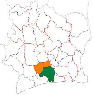
Lôh-Djiboua Region is one of the 31 regions of Ivory Coast. Since its creation in 2011, it has been one of two regions in Gôh-Djiboua District. The regional seat is Divo and the region's area is 10,650 km². At the 2021 census, the region had a population of 1,103,158.
This page is based on this
Wikipedia article Text is available under the
CC BY-SA 4.0 license; additional terms may apply.
Images, videos and audio are available under their respective licenses.
