Eldred, Illinois

Last updated

Eldred, Illinois
James John Eldred House.jpg
James John Eldred House north of Eldred
Greene County Illinois Incorporated and Unincorporated areas Eldred Highlighted.svg
Location of Eldred in Greene County, Illinois.
Illinois in United States (US48).svg
Location of Illinois in the United States
Coordinates: 39°17′12″N90°33′12″W / 39.28667°N 90.55333°W / 39.28667; -90.55333
CountryUnited States
StateIllinois
County Greene
Area
[1]
  Total0.13 sq mi (0.35 km2)
  Land0.13 sq mi (0.35 km2)
  Water0.00 sq mi (0.00 km2)
Elevation
[2]
446 ft (136 m)
Population
 (2020)
  Total149
  Density1,111.94/sq mi (430.17/km2)
Time zone UTC-6 (CST)
  Summer (DST) UTC-5 (CDT)
ZIP Code(s)
62027
Area code 217
GNIS ID2398797 [2]
FIPS code 17-23022
Wikimedia CommonsEldred, Illinois

Eldred is a village in Greene County, Illinois, United States. The population was 149 at the 2020 census. [3]

Contents

History

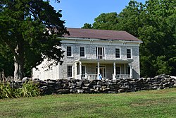
Eldred was founded because of its situation in the Illinois River Bottoms as a town that combined the values of a river and a bluff-side village. Eldred first appeared on river plat books as "Farrow Town" in the 1830s, but was founded sometime before the admittance of Illinois as a state in 1818. A few of its original founders, were of Scotch-Irish ancestry from the Upland South.

Geography

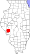
Eldred is located in southwestern Greene County at 39°17′12″N90°33′12″W / 39.28667°N 90.55333°W / 39.28667; -90.55333 (39.286663, -90.553458). [4] Illinois Route 108 passes through the village, leading east 8 miles (13 km) to Carrollton, the Greene County seat, and west 3 miles (5 km) to the Illinois River and the Kampsville ferry.

According to the 2021 census gazetteer files, Eldred has a total area of 0.13 square miles (0.34 km2), all land. [5]

Situated in the lower Illinois River Valley, 30 miles (48 km) north of the Illinois River's confluence with the Mississippi River at Grafton, Eldred is nestled between the soaring limestone bluffs and the fertile bottom land that follow the Illinois in its southern extreme. The bottoms were systematically drained during the 1920s, which caused much contention among the villagers as to the merits of drainage. Nevertheless, the drainage occurred and created a great expanse of farmland for the counties along the river.[ citation needed ]

Demographics

Historical population
CensusPop.Note
1910 241
1920 29823.7%
1930 282−5.4%
1940 34020.6%
1950 298−12.4%
1960 3021.3%
1970 292−3.3%
1980 286−2.1%
1990 254−11.2%
2000 211−16.9%
2010 201−4.7%
2020 149−25.9%
U.S. Decennial Census [6]

As of the 2020 census [3] there were 149 people, 113 households, and 46 families residing in the village. The population density was 1,111.94 inhabitants per square mile (429.32/km2). There were 101 housing units at an average density of 753.73 per square mile (291.02/km2). The racial makeup of the village was 94.63% White, 0.00% African American, 0.00% Native American, 0.67% Asian, 0.00% Pacific Islander, 0.67% from other races, and 4.03% from two or more races. Hispanic or Latino of any race were 0.00% of the population.

There were 113 households, out of which 5.3% had children under the age of 18 living with them, 30.09% were married couples living together, 8.85% had a female householder with no husband present, and 59.29% were non-families. 57.52% of all households were made up of individuals, and 46.90% had someone living alone who was 65 years of age or older. The average household size was 2.96 and the average family size was 1.81.

The village's age distribution consisted of 7.4% under the age of 18, 3.4% from 18 to 24, 7.8% from 25 to 44, 42.2% from 45 to 64, and 39.2% who were 65 years of age or older. The median age was 56.5 years. For every 100 females, there were 98.1 males. For every 100 females age 18 and over, there were 107.7 males.

The median income for a household in the village was $41,875, and the median income for a family was $92,750. Males had a median income of $50,517 versus $40,438 for females. The per capita income for the village was $32,013. About 4.3% of families and 9.8% of the population were below the poverty line, including none of those under age 18 and 13.8% of those age 65 or over.

Related Research Articles

<span class="mw-page-title-main">Hamburg, Illinois</span> Village in Illinois, United States

Hamburg is a village in Calhoun County, Illinois, United States. The population was 99 at the 2020 census, down from 128 at the 2010 census.

<span class="mw-page-title-main">Kampsville, Illinois</span> Village in Illinois, United States

Kampsville is a village in Calhoun County, Illinois, United States, located on the west bank of the Illinois River. The population was 310 at the 2022 census.

<span class="mw-page-title-main">Carrollton, Illinois</span> City in Illinois, United States

Carrollton is a city in and the county seat of Greene County, Illinois, United States. The population was 2,485 as of the 2020 census.

<span class="mw-page-title-main">Greenfield, Illinois</span> City in Illinois, United States

Greenfield is a city in Greene County, Illinois, United States. The population was 1,059 at the 2020 census.

<span class="mw-page-title-main">Hillview, Illinois</span> Village in Illinois, United States

Hillview is a village in Greene County, Illinois, United States. The population was 94 at the 2020 census.

<span class="mw-page-title-main">Kane, Illinois</span> Village in Illinois, United States

Kane is a village in Greene County, Illinois, United States. The population was 296 at the 2020 census.

<span class="mw-page-title-main">Rockbridge, Illinois</span> Village in Illinois, United States

Rockbridge is a village in Greene County, Illinois, United States. The population was 175 at the 2020 census.

<span class="mw-page-title-main">Wilmington, Greene County, Illinois</span> Village in Illinois, United States

Wilmington (Patterson) is a village in Greene County, Illinois, United States. The population was 91 at the 2020 census.

<span class="mw-page-title-main">Goreville, Illinois</span> Village in Illinois, United States

Goreville is a village in Johnson County, Illinois, United States. The population was 1,049 as of the 2010 census, up from 938 at the 2000 census.

<span class="mw-page-title-main">Fults, Illinois</span> Village in Illinois, United States

Fults is a village in the Renault precinct of Monroe County, Illinois, United States. The population was 28 at the 2020 census. It is located entirely within the American Bottom floodplain of the Mississippi River.

<span class="mw-page-title-main">Bluffs, Illinois</span> Village in Illinois, United States

Bluffs is a village in Scott County, Illinois, United States. The population was 715 at the 2010 census. It was briefly (1969–1971) the location of the WJJY TV Mast, the tallest structure built to that date in Illinois.

<span class="mw-page-title-main">Athensville Township, Greene County, Illinois</span> Township in Illinois, United States

Athensville Township is one of thirteen townships in Greene County, Illinois, USA. As of the 2020 census, its population was 292 and it contained 131 housing units.

<span class="mw-page-title-main">Bluffdale Township, Greene County, Illinois</span> Township in Illinois, United States

Bluffdale Township is one of thirteen townships in Greene County, Illinois, USA. As of the 2020 census, its population was 454 and it contained 241 housing units.

<span class="mw-page-title-main">Linder Township, Greene County, Illinois</span> Township in Illinois, United States

Linder Township is one of thirteen townships in Greene County, Illinois, USA. As of the 2020 census, its population was 295 and it contained 132 housing units.

<span class="mw-page-title-main">Patterson Township, Greene County, Illinois</span> Township in Illinois, United States

Patterson Township is one of thirteen townships in Greene County, Illinois, USA. As of the 2020 census, its population was 404 and it contained 213 housing units.

<span class="mw-page-title-main">Rockbridge Township, Greene County, Illinois</span> Township in Illinois, United States

Rockbridge Township is one of thirteen townships in Greene County, Illinois, USA. As of the 2020 census, its population was 1,562 and it contained 715 housing units.

<span class="mw-page-title-main">Roodhouse Township, Greene County, Illinois</span> Township in Illinois, United States

Roodhouse Township is one of thirteen townships in Greene County, Illinois, USA. As of the 2020 census, its population was 1,869 and it contained 939 housing units.

<span class="mw-page-title-main">Walkerville Township, Greene County, Illinois</span> Township in Illinois, United States

Walkerville Township is one of thirteen townships in Greene County, Illinois, USA. As of the 2010 census, its population was 188 and it contained 84 housing units.

<span class="mw-page-title-main">Woodville Township, Greene County, Illinois</span> Township in Illinois, United States

Woodville Township is one of thirteen townships in Greene County, Illinois, USA. As of the 2020 census, its population was 212 and it contained 108 housing units.

<span class="mw-page-title-main">Wrights Township, Greene County, Illinois</span> Township in Illinois, United States

Wrights Township is one of thirteen townships in Greene County, Illinois, USA. As of the 2020 census, its population was 224 and it contained 119 housing units.

References

  1. "2020 U.S. Gazetteer Files". United States Census Bureau. Retrieved March 15, 2022.
  2. 1 2 U.S. Geological Survey Geographic Names Information System: Eldred, Illinois
  3. 1 2 "Explore Census Data". data.census.gov. Retrieved June 28, 2022.
  4. "US Gazetteer files: 2010, 2000, and 1990". United States Census Bureau. February 12, 2011. Retrieved April 23, 2011.
  5. Bureau, US Census. "Gazetteer Files". Census.gov. Retrieved June 29, 2022.
  6. "Census of Population and Housing". Census.gov. Retrieved June 4, 2015.