
East Otto is a town in Cattaraugus County, New York, United States. The population was 977 at the 2020 census. The town, along with neighboring Otto, is named after an agent of the Holland Land Company, Jacob Otto. The town of East Otto is on the northern border of the county.

Otto is a town in Cattaraugus County, New York, United States. The population was 775 at the 2020 census. The name comes from Jacob S. Otto, an agent of the Holland Land Company. The town lies on the northern border of Cattaraugus County.

Ellicottville is a village in Cattaraugus County, New York, United States. The population was 284 at the 2020 census. The village is named after Joseph Ellicott, principal land agent of the Holland Land Company. It lies in the southwest part of the town of Ellicottville and is north of the city of Salamanca.
Ellicottville is a town in Cattaraugus County, New York, United States. The population was 1,317 at the 2020 census. The town is named after Joseph Ellicott, principal land agent of the Holland Land Company.
Little Valley is a village in Cattaraugus County, New York, United States and as the county seat, is the location of the county fair. The village is in the northwest corner of the town of Little Valley, which is north of Salamanca. The village population was 1,084 at the 2020 census, out of a population of 1,740 within the entire town.

This is intended to be a complete list of properties and districts listed on the National Register of Historic Places in Cattaraugus County, New York. The locations of National Register properties and districts for which the latitude and longitude coordinates are included below, may be seen in a map.
Irving is a hamlet in Chautauqua County, New York, United States. It is located near the eastern town line and the eastern county line in the town of Hanover. U.S. Route 20 and New York State Route 5 pass through the hamlet, which is next to Cattaraugus Creek; New York State Route 438 terminates just across the creek. The elevation of the hamlet is 584 feet (178 m) above sea level. The ZIP Code for Irving is 14081.
West Valley is a hamlet in the Town of Ashford in Cattaraugus County, New York, United States. The population was 518 at the 2010 census, which lists the community as a census-designated place.

U.S. Route 219 (US 219) is a part of the U.S. Highway System that runs from Rich Creek, Virginia, to West Seneca, New York. In the U.S. state of New York, US 219 extends 67.63 miles (108.84 km) from the Pennsylvania state line at Carrollton to an interchange with the New York State Thruway at exit 55 in West Seneca, southeast of downtown Buffalo. In Cattaraugus County, the area surrounding US 219 is predominantly rural. However, in northern Cattaraugus County, US 219 becomes an expressway leading through Erie County and into the heart of Buffalo. The route serves the villages of Ellicottville and Springville, where it meets New York State Route 242 (NY 242) and NY 39, respectively, and indirectly serves Hamburg via NY 391.

The Southtowns is a region of Western New York, United States, that lies within the snowbelt or ski country. It includes the southern suburbs of Buffalo, New York. This is the common name for the southern part of Erie County, New York.

Scoby Power Plant and Dam is a historic dam and power plant located between the towns of Ashford and Concord, near Springville, New York. The complex is located on the eastern bank of Cattaraugus Creek outside Springville. It is representative of a small hydroelectric generating facility of the early 20th century in Western New York. The complex was constructed in 1925, replacing a facility near this site.
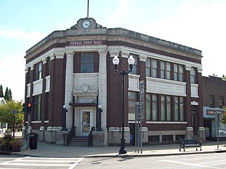
Bank of Gowanda is a historic bank building located at Gowanda in Cattaraugus County, New York. It was built in 1914, to the designs of Edvard Moeller. It is a two-story, five-sided Neoclassical style building constructed of load bearing concrete masonry and clad in red brick. The interior features a mural by noted artist Louis Grell. Since 1966, the structure has served as town hall for the town of Persia, New York.
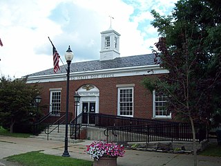
East Otto Union School is a historic school building located at East Otto in Cattaraugus County, New York. It was built in 1920, and functioned as a local high school from 1921 to the 1950s, after which the school was merged into the Cattaraugus Central School 12 miles to the southwest. It is a Colonial Revival style frame building that features a distinctive cupola. Since 1972, the structure has served as town hall for the town of East Otto, New York.

Bryant Hill Cemetery is a historic cemetery located at Ellicottville in Cattaraugus County, New York. In 1821, Samuel Bryant set aside land to serve as the first cemetery at Ellicottville; the first burial was in 1824 and the last in 1901. Restoration of the cemetery began in 1970, and it became the property of the town of Ellicottville in 1976. It is the final resting site for many of the area's early New England settlers.

Bedford Corners Historic District is a historic district located at Portville in Cattaraugus County, New York. The district consists of three structures located at the intersection at New York State Route 305 and Deer Creek Road / Dodge Creek Road. The structures are a two-story, "L" shaped, frame dwelling built about 1856 by early settler Jacob Bedford; a one-room schoolhouse built in 1864; and the Bedford Corners Cheese Factory / Grange Hall built after 1886. The district also includes the 50 acres (20 ha) surrounding the structures.

Ellicottville Historic District is a historic district located at Ellicottville in Cattaraugus County, New York. The district encompasses the historic core of the village of Ellicottville with structures associated with the civic, commercial, religious, educational, and residential life of the village between 1817 and 1935. The structures reflect a variety of 19th-century and early 20th-century architectural styles including Queen Anne, Federal, and Greek Revival styles. The district contains 63 contributing and 3 non-contributing structures. Located within the district is the Ellicottville Town Hall.

Jefferson Street Cemetery is a historic cemetery located at Ellicottville in Cattaraugus County, New York. The cemetery was established in 1817 and was the first to serve the village. It is a settlement era burial ground consisting of eight to ten rows of burials. There are over 400 burials dating from 1817 to 2003. The markers are of marble, granite, and sandstone.
DeHart Henry Ames was an American businessman and politician from New York.
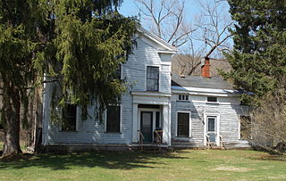
The John J. Aiken House is a historic house located at 6805 Poverty Hill Road in Ellicottville, Cattaraugus County, New York.


