
Lugano Airport is a regional airport located 4 km (2.5 mi) west of the Swiss city of Lugano, approximately 80 km (50 mi) north of Milan, in the municipalities of Agno, Bioggio and Muzzano. It lies closer to the village of Agno than to Lugano itself, and is sometimes known as Lugano-Agno. Around 200,000 passengers use the airport each year, using some 2,400 flights. There are also limited freight operations, a flying club and flight school. The headquarters of Darwin Airline were located at the airport prior to its bankruptcy.
Skagit Regional Airport is a public airport located three miles (5 km) west of the central business district of Burlington and northwest of Mount Vernon, both cities in Skagit County, Washington, United States. The airport is owned by the Port of Skagit County. It is situated in the Bayview Industrial Park.

Tillamook Airport is a public use airport located 3 miles (4.8 km) south of the central business district of Tillamook, a city in Tillamook County, Oregon, United States. It is owned by the Port of Tillamook Bay. According to the FAA's National Plan of Integrated Airport Systems for 2009–2013, it is categorized as a general aviation facility.
Monroe County Airport is a county-owned, public-use airport located two nautical miles northwest of the central business district of Madisonville, a town in Monroe County, Tennessee, United States.
Walker County Airport, also known as Bevill Field, is a public airport located five miles (8 km) northwest of the central business district of Jasper, a city in Walker County, Alabama, United States. It is owned by the Walker County Commission.
Warsaw Municipal Airport is a city-owned public-use airport located six miles (10 km) north of the central business district of Warsaw, a city in Benton County, Missouri, United States.
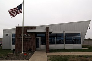
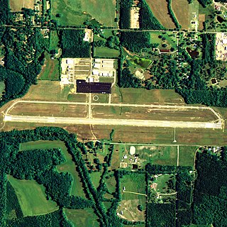
Buffalo Municipal Airport is a city-owned public-use airport located two miles (3 km) southeast of the central business district of Buffalo, a city in Wright County, Minnesota, United States.
Cambridge Municipal Airport is a city-owned public-use airport located two miles (3 km) southwest of the central business district of Cambridge, a city in Isanti County, Minnesota, United States.
Winchester Municipal Airport is a city-owned public-use airport located three nautical miles southeast of the central business district of Winchester, a city in Franklin County, Tennessee, United States.
Cloquet Carlton County Airport is a county-owned public-use airport located three nautical miles (6 km) southwest of the central business district of Cloquet, a city in Carlton County, Minnesota, United States.
Scott Municipal Airport is a public-use airport located four nautical miles southwest of the central business district of Oneida, a city in Scott County, Tennessee, United States. The airport is owned by Scott County. Big South Fork Airpark, a gated community and residential airpark is located adjacent to the airport.
Fayette County Airport is a county-owned, public-use airport located two nautical miles southwest of the central business district of Somerville, in Fayette County, Tennessee, United States. According to the FAA's National Plan of Integrated Airport Systems for 2009–2013, it was classified as a general aviation airport.
Red Lodge Airport is a public use airport located one nautical mile northwest of the central business district of Red Lodge, a city in Carbon County, Montana, United States. It is owned by the City of Red Lodge and Carbon County. According to the FAA's National Plan of Integrated Airport Systems for 2009–2013, it is categorized as a general aviation airport.

Abernathy Field is a public use airport located three nautical miles southwest of the central business district of Pulaski, a city in Giles County, Tennessee, United States. It is owned by the City of Pulaski and Giles County. According to the FAA's National Plan of Integrated Airport Systems for 2009–2013, it is categorized as a general aviation facility.
Orange City Municipal Airport was a city-owned public-use airport located one nautical mile (1.85 km) south of the central business district of Orange City, a city in Sioux County, Iowa, United States. This airport was included in the FAA's National Plan of Integrated Airport Systems for 2009–2013, which categorized it as a general aviation facility.
Campbell County Airport is a county-owned, public-use airport located 1 kilometre (0.62 mi) east of the central business district of Jacksboro, a town in Campbell County, Tennessee, United States. This airport is included in the FAA's National Plan of Integrated Airport Systems for 2011–2015, which categorized it as a general aviation facility.
Beech River Regional Airport is a public-use airport in Henderson County, Tennessee, United States. It is located five nautical miles northwest of the central business district of Parsons, a city in Decatur County.
Hawkins County Airport is a county-owned public-use airport in Hawkins County, Tennessee, United States. It is located six nautical miles northeast of the central business district of Rogersville, Tennessee in the city of Surgoinsville, Tennessee. This airport is included in the National Plan of Integrated Airport Systems for 2011–2015, which categorized it as a general aviation facility.

